Copyright Newsweek
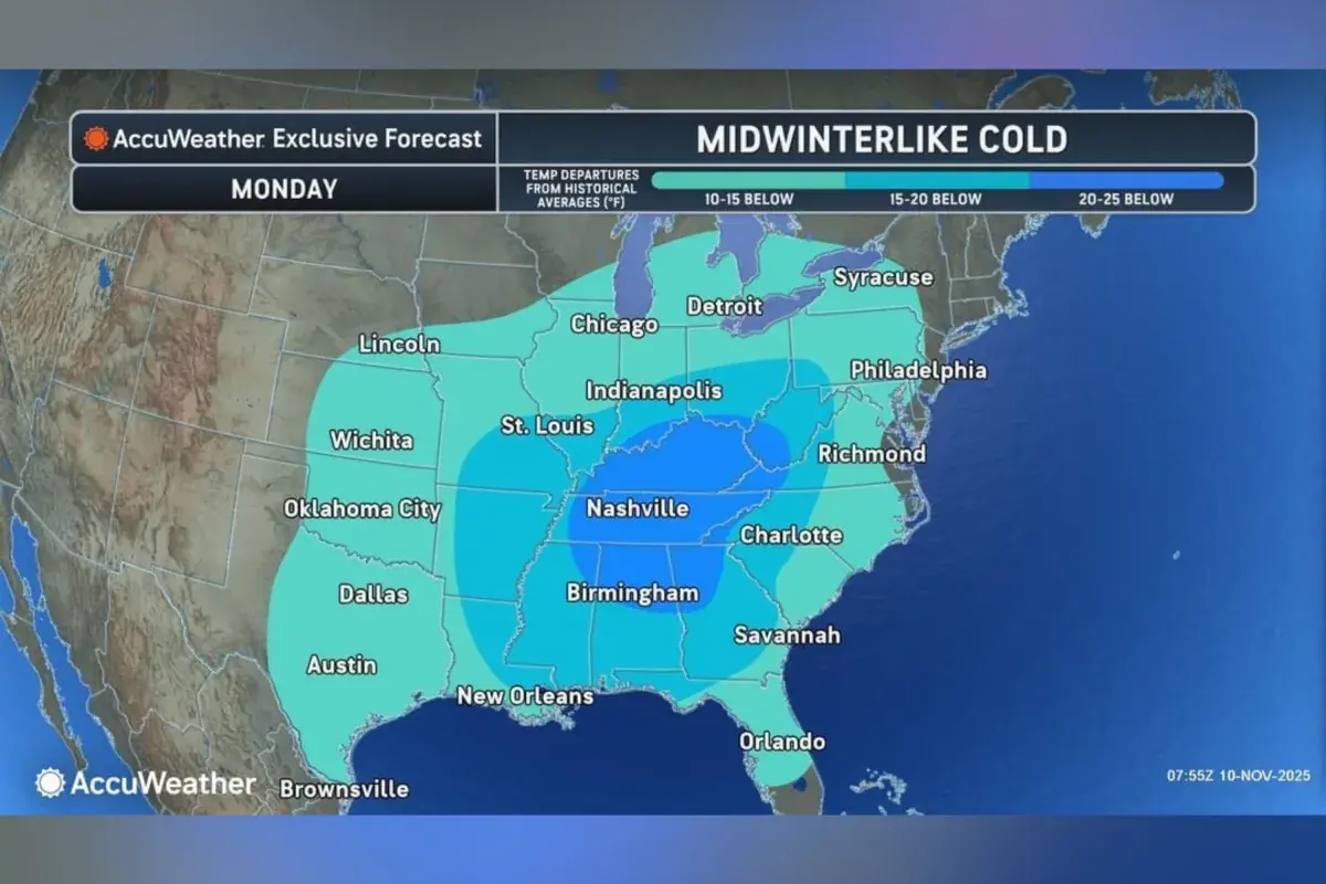
Forecasts provided to Newsweek by AccuWeather highlight which states can expect temperatures to drop notably below average early this week, as a surge of cold air sweeps across the country. Why It Matters As of Monday morning, swaths of the eastern United States have been issued weather alerts by the National Weather Service (NWS), with the agency warning that inclement conditions could lead to hazardous travel for millions of Americans. What To Know In an advisory shared with Newsweek on Monday, AccuWeather stated that a powerful surge of Arctic air from Canada is sweeping south into the Plains, Midwest, and East, causing daytime highs to tumble into the 20s and 30s as far south as the Appalachians and New York. The bitter cold will extend to the Gulf Coast and Florida Panhandle by Monday night, with high temperatures in cities like Atlanta and Chicago dropping into the 40s and 30s, according. A forecast map provided by AccuWeather showed that several states are anticipated to see temperatures 20-25 degrees below historical averages on Monday. This includes much of Tennessee and Kentucky, southwestern West Virginia, far western portions of Virginia and North Carolina, northern Alabama, northeast Mississippi, northwest Georgia, as well as southern portions of Indiana and Ohio. What People Are Saying AccuWeather meteorologist Adam Douty told Newsweek on Monday: “The coldest conditions (as a whole) will be felt today and on Tuesday. Temperatures from the Midwest into the Ohio Valley and Southwest will be the lowest today, while the Eastern Seaboard will have the lowest temperatures tomorrow. It will remain cold across the Northeast on Wednesday, though most other areas will see moderating temperatures into midweek.” The National Weather Service forecast office, Nashville, Tennessee, said Saturday on X: “Much colder air will move in starting Sunday. The coldest period will be Sunday night through Tuesday morning with lows in the upper teens/20s. Light snow is in the forecast Sunday night and early Monday, mainly along the Cumberland Plateau. Higher elevations could see around [half an inch].” The NWS said Friday on X: “A strong cold front this weekend will put the ‘ber’ in November as frigid air spills out across the Plains and Mississippi Valley. This winter-like chill will flood across the eastern half of the country early next week, bringing the potential for record cold temperatures to the Gulf Coast by Tuesday.” What Happens Next Local forecast updates are issued regularly by the NWS on its website and via its social media channels.