Copyright thehindubusinessline
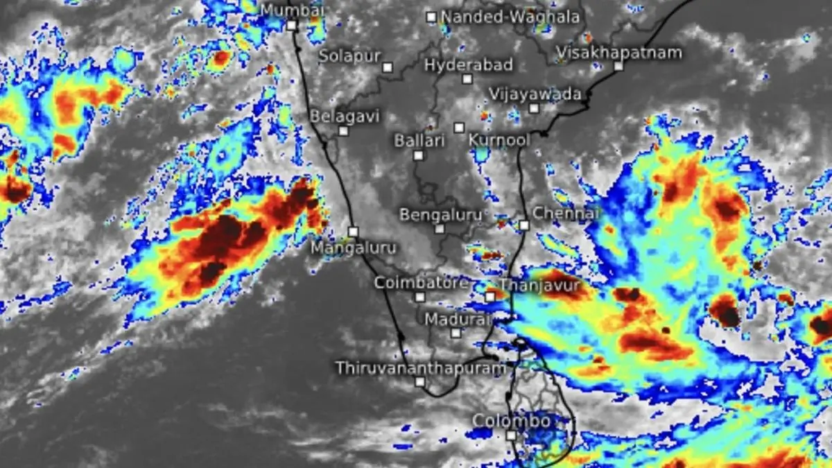
India Meteorological Department (IMD) has upgraded weather warning for Andhra Pradesh coast to that a severe cyclone, as a causative depression on Saturday set itself on a journey towards the coast from its current bearing over Bay of Bengal waters. It was located on Saturday evening over south-east Bay about 460 km west-southwest of Port Blair; 950 km east-southeast of Chennai; 960 km south-east of Visakhapatnam; 970 km south-east of Kakinada; and 1,030 km south-southeast of Gopalpur. Steady intensification It may move west-northwest, intensify into a deep depression by Sunday and further into cyclone Montha over south-west and adjoining west-central Bay off north Tamil Nadu and Andhra Pradesh coast by Monday morning. Thereafter, will steer itself itself to north-west, north-northwest, and back to north-west, before intensifying into a severe cyclone by Tuesday morning. Landfall by Tuesday night Tracking further north-northwest, it may cross Andhra Pradesh coast between Machilipatnam and Kalingapatnam around Kakinada during evening/night of Tuesday as a severe cyclone with wind speeds of 90-100 km/hr gusting to 110 km/hr. Extreme heavy rain Extremely heavy rainfall has been warned of over south coastal Andhra Pradesh on Monday; over Coastal Andhra Pradesh for three days from Tuesday; over Rayalaseema on Monday and Tuesday; and also over south Odisha on Tuesday and Wednesday. Very heavy rain Very heavy rainfall is likely over Tamil Nadu; Kerala and Mahe; and Coastal Karnataka on Monday. Isolated very heavy rainfall is likely over Andaman and Nicobar Islands on Sunday; over Odisha for three days from Monday; and over Chhattisgarh on Wednesday. To the East and North-East, isolated heavy rainfall is likely over Assam and Meghalaya; and Nagaland, Manipur, Mizoram and Tripura for three days from Wednesday; and Arunachal Pradesh on Thursday. Arabian Sea depression Meanwhile, a twin depression over east-central Arabian Sea, to the other side of the peninsula, moved west-northwest and lay centred 450 km west-northwest of Panjim; 430 km south-west of Mumbai; 680 km north-west of Mangaluru; and 690 km north-northwest of Aminidivi. It may move north-west across east-central Arabian Sea in the direction of Konkan coast till Sunday. Rain outlook Isolated heavy rainfall is forecast over south Konkan and Goa and south Madhya Maharashtra on Monday; over Gujarat for three days from Sunday. It will be isolated very heavy rainfall over Saurashtra on Sunday. An incoming western disturbance is expected to pass through North-West and adjoining East India and likely interact with monsoon southwesterlies from Arabian Sea and south-easterlies from Bay systems, bringing rain to parts of these regions. The 24 hours ending Saturday morning saw heavy to very rainfall being recorded over Goa; Tamil Nadu and Puducherry; Nicobar Island; and Coastal Karnantaka while it was heavy over Rayalaseema; Coastal Andhra Pradesh; and North Interior Karnataka. Published on October 25, 2025