Copyright Santa Rosa Press Democrat
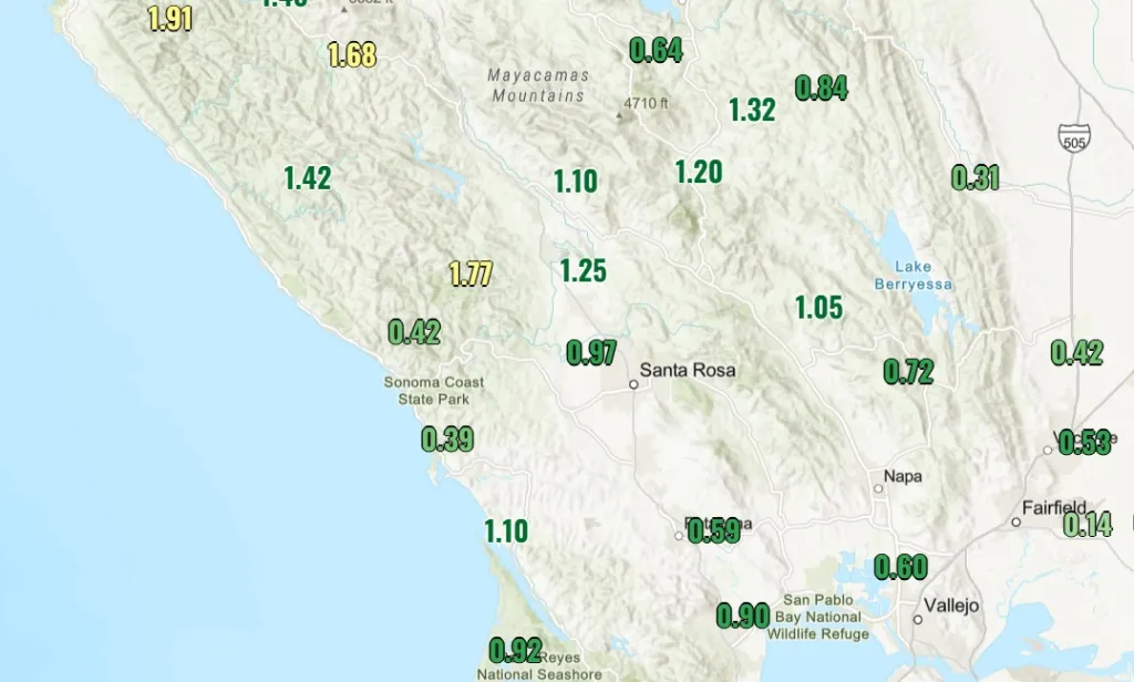
A windy early-season storm that began Tuesday night doused Sonoma and Napa counties, with parts of the region seeing almost 2 inches of rain and slick roads and swollen creeks by early Wednesday afternoon, according to the National Weather Service. By about 1 p.m., between about 0.5 to 1.5 inches of rainfall were recorded in valley locations, with Cloverdale receiving 1.45 inches, Santa Rosa getting 1.2, Yountville about 1.4, Sonoma around 1.3, and Napa at 1.35. The highest totals were around Venado, with about 1.8 inches, and Mount Veeder with 1.9, according to the weather service There were a few reported cases of flooding in poor drainage areas, but nothing impactful or out of the ordinary, said Brayden Murdock, a meteorologist with the weather service in the Monterey office. This is likely because the rain was spread out over time, he said. Creeks and streams such as Matanzas and Colgan in Sonoma County, jumped in height, though none appeared to be overflowing. “We actually kind of lucked out,” Murdock said. “A lot of our flooding has been manageable.” Strong winds passed through the North Bay Wednesday morning and then moved steadily south. Most higher elevations saw wind gusts between 50 to 70 mph, with Mount Saint Helena recording a gust of 63 mph. The highest recorded gust in the North Bay was 82 mph on Gunsight Fire Road in Marin County. The wet weather caused multiple small power outages across the North Bay and forced a school closure in Annapolis. Horicon Elementary canceled classes Wednesday after a power line was knocked onto the ground, cutting off power to the Annapolis Road campus, according to Sonoma County Office of Education spokesperson Eric Wittmershaus. As of about 1:30 p.m., only six Pacific Gas and Electric Co. customers in Sonoma County were without power, most due to the storm. Murdock said scattered showers were possible into Wednesday night, though the chances were expected to decrease through the afternoon and evening, the weather service’s Murdock said. No rain is expected through the rest of the week. Starting Thursday, large waves from the northwest will reach the coast, increasing the possibility of beach hazards such as sneaker waves and rip currents, with breakers up to 15 feet high. The large waves will only exacerbate the arrival of king tides, which create large swings between high and low tides, Murdock said. A coastal flood advisory that began Tuesday morning will remain in effect through 2 p.m. Saturday as seawater could rise about a foot above normal in low-lying coastal areas. “Wave activity will be strong,” he said. “We want the public to be really careful.”