Copyright ieyenews
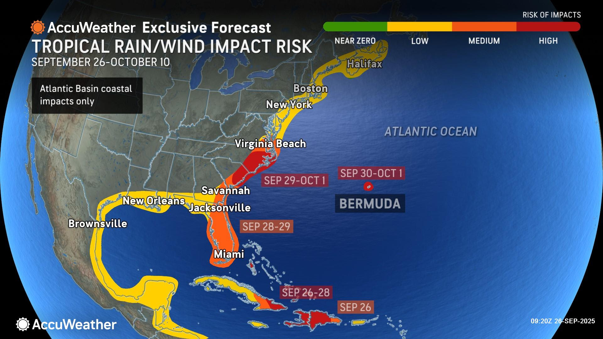
Humberto forecast to strengthen into a major hurricane this weekend > Humberto is forecast to pass between Bermuda and the U.S. East Coast early next week > A meteorological tug of war will likely determine whether an emerging storm moving toward the Bahamas will bring impacts to the Southeast U.S. early next week, or if Humberto will pull it out to sea AccuWeather® Global Weather Center – Sept. 26, 2025 – AccuWeather® hurricane experts are urging people, businesses and officials in the Southeast U.S. to prepare now for possible tropical rain and wind impacts early next week, including the potential of a major flooding threat. AccuWeather® Lead Hurricane Expert Alex DaSilva says a tropical rainstorm that formed near Hispaniola is expected to organize into a tropical storm and track toward the Southeast U.S. early next week. AccuWeather uses the term “tropical rainstorm” to describe certain tropical systems that may bring significant impacts from rain or wind before they are officially classified as a tropical depression or storm in order to raise public awareness of their disruptive, damaging and dangerous potential. “There is an increasing potential for flooding rainfall in the Carolinas, especially if the storm lingers along the coast or if it stalls over land. We are advising people across the Carolinas to be prepared for the possibility of a landfalling storm between Monday and Wednesday,” DaSilva said. “The tropical rainstorm moving toward the Bahamas will enter an area with less disruptive wind shear and very warm waters. Atmospheric conditions near the Bahamas should support tropical development over the weekend. Tropical downpours could soak islands across the Caribbean.” The next name on the list of 2025 Atlantic hurricanes is Imelda. This tropical rainstorm has the potential to quickly gain wind intensity this weekend as it nears the Bahamas. If that occurs, it could become a hurricane later this weekend or early next week, raising the risk of greater impacts across the Southeast. Regardless of a landfall, AccuWeather® hurricane experts have increasing confidence in a heavy rainfall threat that could lead to flooding across portions of the southeastern U.S. next week. This rainfall is expected to occur from Georgia through the Carolinas as tropical moisture is drawn northward ahead of the storm. Dangerous and potentially life-threatening flooding is possible, as well as storm surge impacts at the coast and gusty winds. Hundreds of miles to the east, Hurricane Humberto is expected to rapidly strengthen and track between Bermuda and the East Coast early next week. “Humberto is the third hurricane of the season, and it’s forecast to become the third major hurricane of the year. The storm is moving west into an area with little disruptive wind shear and warm waters. This hurricane is forecast to pass between Bermuda and the U.S. East Coast next week. Humberto may bring gusty winds and several inches of rain to Bermuda,” DaSilva said. “Both storms will likely create dangerous rough surf and rip currents across the Bahamas and along much of the East Coast starting Sunday.” AccuWeather® hurricane experts say the exact track and strength of the tropical rainstorm, after it organizes over the weekend and early next week, will determine the location and severity of impacts to the southeastern U.S. early next week. “The proximity of two storms expected within hundreds of miles of each other has made this a challenging and complex forecast. There may be a meteorological tug of war between Humberto and an area of low pressure that is high in the atmosphere over the Southeast U.S. early next week,” DaSilva explained. “If Humberto has more influence, it could pull this new storm further east and away from the coast. If the upper low has more influence, it may pull this emerging storm toward the East Coast.” The first scenario is for a storm with lower wind intensity being guided east toward a stronger Humberto. This may cause the storm to become completely enveloped and absorbed by Humberto, or dancing around it in a phenomenon known as the Fujiwhara Effect. The impacts to the U.S. would likely be limited to heavy downpours preceding the storm in the Southeast, along with rough surf and a risk of rip currents along the East coast. A second scenario would result in a stronger storm tracking more directly toward the southeastern U.S. coast early next week. This is because the storm would remain separate from Hurricane Humberto. This scenario would likely result in expansive and prolonged heavy rain and flooding, even inland, as well as damaging winds, especially across the Carolinas. AccuWeather® hurricane experts are encouraging people and businesses in the Southeast U.S. to check and restock emergency kits and to review local evacuation zones and evacuation routes. AccuWeather® hurricane experts reduced the maximum number of named storms and hurricanes forecast to develop this year due to the unusual midseason lull. The AccuWeather® 2025 Atlantic Hurricane Season Forecast now predicts 13-16 named storms and six to nine hurricanes. It is important to note that the forecast for three to six direct impacts on the U.S. has not changed, despite a slight lowering of the total number of storms and hurricanes.