Copyright ieyenews
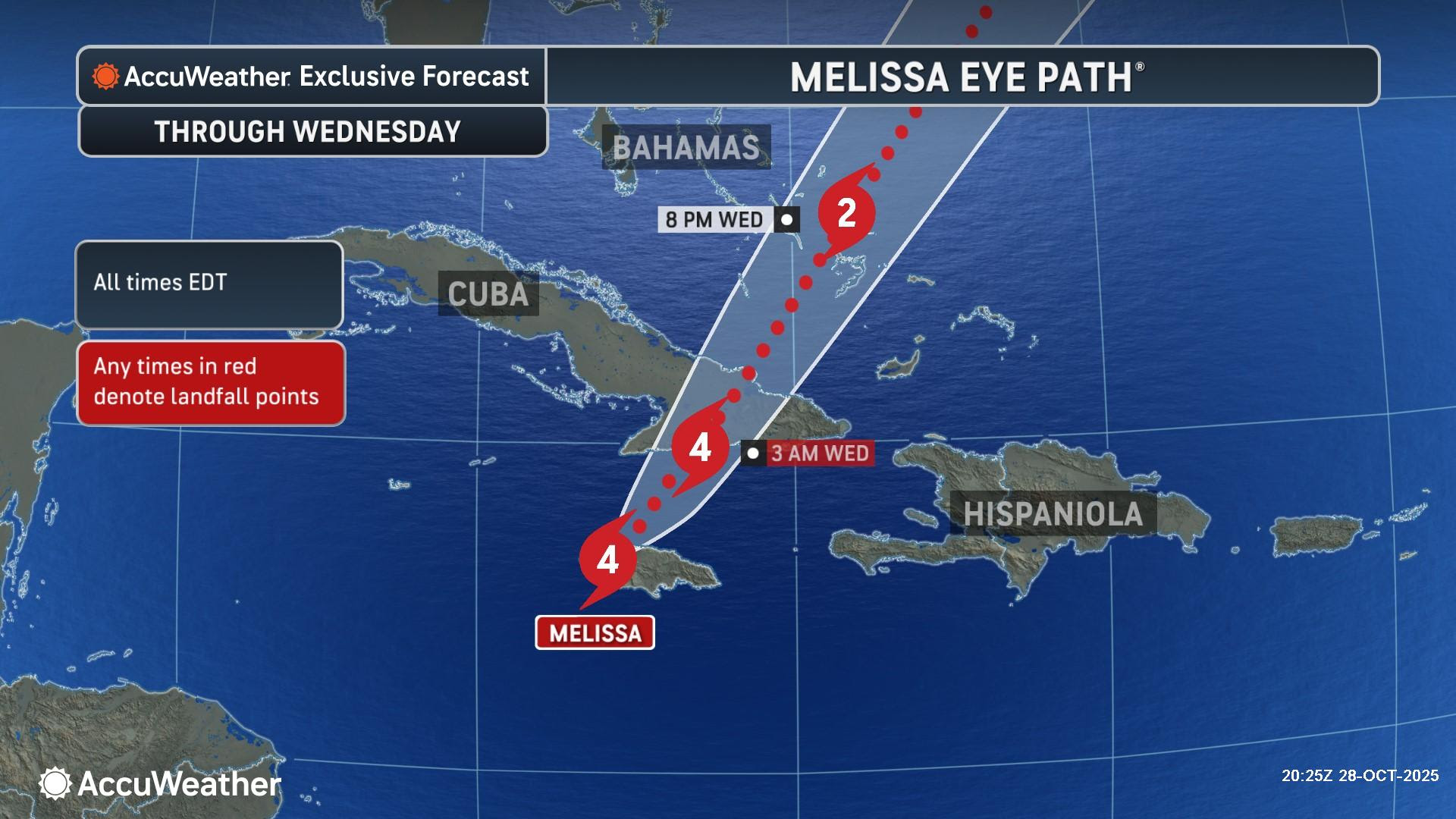
AccuWeather Public Relations Strong second landfall expected, this time in Cuba: Melissa’s trek across western Jamaica encountered less mountainous terrain compared to eastern Jamaica, allowing a stronger storm to emerge over the warm waters of the Caribbean as it advances toward Cuba. > Widespread damage in Jamaica: AccuWeather® experts say the preliminary estimate for total damage and economic loss from Hurricane Melissa in Jamaica is $22 billion. > Record-shattering storm already: Melissa sets record with strongest landfall on record in Jamaica. Melissa ties the 1935 Labor Day Hurricane that hit the Florida Keys as the strongest hurricane upon landfall in the Atlantic basin in terms of wind speed and barometric pressure. AccuWeather® Global Weather Center – Oct. 28, 2025 – As Hurricane Melissa brings catastrophic wind, torrential rainfall and destructive storm surge to Jamaica, AccuWeather® hurricane experts are warning people in southern Cuba to prepare for a major hurricane landfall early Wednesday morning. “The damage from this historic hurricane landfall is devastating. This was the first direct strike from a Category 5 hurricane in Jamaica’s recorded history. Melissa had a tight inner core with the strongest winds roughly 20 miles across as it moved through western Jamaica. It may be a narrow path, but there will be significant destruction. The damage may look similar to EF3 and EF4 tornadoes that we see in the United States. Melissa brought catastrophic flooding and wind damage across the island. People in western Jamaica could be stranded for days or weeks. It will be incredibly difficult for emergency aid and resources to reach the hardest hit areas,” AccuWeather® Chief Meteorologist Jonathan Porter said. “The worst impacts from Melissa struck Jamaica during the daylight hours. People across Cuba need to be prepared for a dangerous, direct hit from Melissa in the dark.” AccuWeather® hurricane experts say conditions will slowly begin to improve Tuesday night as life-threatening, catastrophic flooding and destructive winds begin to move north of Jamaica. Cuba now bracing for impending landfall overnightStrong winds, heavy rain and storm surge will increase in eastern Cuba late Tuesday into Wednesday as the storm moves over the island. AccuWeather now forecasts a Category 4 landfall in southeast Cuba early Wednesday morning, with wind gusts of 140-160 mph, a damaging storm surge of 10-15 feet and 18-24 inches of rainfall. “Melissa maintained much of its strength as it moved over western Jamaica. The storm interacted with less mountainous terrain than it would have if it crossed the center or eastern parts of the island,” Porter said. “Warm waters in the Caribbean will provide additional fuel for the storm tonight, before it makes its second landfall in Cuba. People in Cuba need to be hunkered down in a sturdy building or safe shelter tonight. The dangers from hurricane-force winds, torrential rainfall, and storm surge are incredibly dangerous, especially in the dark.” Wind gusts of 60-80 mph can occur over Bermuda later in the week as the storm moves close to the islands. Wind gusts of 40-60 mph will be possible in Nova Scotia as Melissa moves well to the east later Friday into Saturday. Catastrophic Damage in Jamaica AccuWeather® experts say the preliminary estimate of total damage and economic loss from Hurricane Melissa in Jamaica is $22 billion. The AccuWeather® preliminary estimate of total damage and economic loss accounts for damage to homes and businesses, disruptions to commerce and supply chain logistics, tourism losses, impacts to shipping operations at major hubs, financial losses from extended power outages, major travel delays, as well as damage to infrastructure. This is a preliminary estimate, as the storm effects continue to be felt, and some areas have not yet reported complete information about damage, injuries and other impacts. AccuWeather® incorporates independent methods to evaluate all direct and indirect impacts of the storm, which include both insured and uninsured losses and are based on a variety of sources, statistics and unique techniques AccuWeather® uses to estimate damage. It includes damage to property, job and wage losses, crops, infrastructure, interruption of the supply chain, auxiliary business losses and flight delays. The estimate also accounts for the costs of evacuations, relocations, emergency management and the extraordinary government expenses for cleanup operations and the long-term effects on business logistics, transportation and tourism as well as the long-term and short-term health effects and the medical and other expenses of unreported deaths and injuries. AccuWeather® is the trusted source for total damage and economic loss estimates for weather disasters in the United States. Our recognized experts incorporate independent methods to evaluate all direct and indirect impacts of extreme weather events. In 2017, AccuWeather® first issued a widely quoted preliminary estimate for total damage and economic loss during catastrophic flooding from Hurricane Harvey along the Gulf coast, which helped people in the impacted area and across the country to better understand the magnitude of the disaster. Historic storm on several fronts AccuWeather® hurricane experts say Melissa tied two other hurricanes as the strongest recorded landfall on record in the Atlantic basin. Hurricane Melissa, Hurricane Dorian in 2019 and the Labor Day storm of 1935 all had a landfall with maximum sustained winds of 185 mph. Melissa also had the same minimum central pressure of 892 millibars (26.34 inches) as the Labor Day storm of 1935. The strength of a hurricane is closely tied to its barometric pressure. Extremely low pressure at the storm’s core indicates intense upward motion and a tighter circulation, which creates stronger winds and more destructive potential. AccuWeather® Founder and Executive Chair Dr. Joel N. Myers said, “You only have 89 percent of the pressure that is normal at sea level. Basically, there’s 11 percent less air above you in the center of this hurricane than elsewhere and that difference in pressure is what powers the winds.” “Interestingly, when winds go counterclockwise around a low-pressure area which is what a hurricane is, compared to clockwise in a high, given the same pressure gradient, the winds are less. If you had the same pressure gradient around a high pressure area, the winds would be much stronger. If you take the 175 mph winds in Melissa, but if they were blowing around a high pressure with the same pressure gradient, you would have winds probably close to 250 mph,” Myers explained. “This is one of the scientific paradoxes. Nonetheless, it still is pretty extraordinary to think about 11 percent less air above you at sea level in the eye of Melissa compared to normal sea level atmosphere pressure. The pressure in the center of Melissa is the same as the average pressure you would encounter on a mountain 3,500 feet above sea level.