Copyright thehindubusinessline
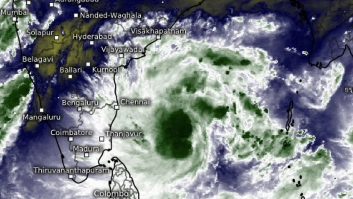
A cyclone alert and (orange message) has been issued for Andhra Pradesh, Yanam and south Odisha coast as Saturday’s depression over south-east Bay of Bengal moved nearly west-northwest and intensified into a deep depression over the same region, the penultimate stage before being named as a tropical cyclone. The deep depression was located this Sunday evening about 620 km west of Port Blair; 770 km east-southeast of Chennai; 820 km south-southeast of Visakhapatnam; 810 km south-east of Kakinada; and 920 km south-southeast of Gopalpur (Odisha), an India Meteorological Department (IMD) update said. Extremely heavy rain Extremely heavy rainfall (≥21 cm) has been forecast over Coastal Andhra Pradesh and Yanam for three days from Monday, and over Telangana, on Tuesday. Extremely heavy rainfall is also likely over south Odisha on Tuesday and Wednesday; and over Chhattisgarh on Tuesday. Very heavy rain is likely over Rayalaseema and Tamil Nadu on Monday and Tuesday; Kerala and Mahe and Coastal Karnataka on Monday; Coastal Andhra Pradesh and Yanam for three days; and over Telangana on Tuesday and Wednesday, the IMD said. No change in outlook It may move west-northwest and intensify further into a cyclone (to be named as Montha in Thai language) over Bay waters slightly away from north Tamil Nadu and Andhra Pradesh coasts by Monday morning. Thereafter, it is likely to move north-west and later north-northwest, and intensify into a severe cyclone storm by Tuesday morning. Continuing to move further north-northwest, it may cross Andhra Pradesh coast between Machilipatnam and Kalingapatnam around Kakinada during Tuesday evening/night as a severe cyclone with maximum sustained wind speeds of 90-100 km/hr gusting to 110 km/hr, the IMD said. Rainfall outlook Meanwhile, on Sunday morning, the other depression over east-central Arabian Sea lay centred about 790 km southwest of Mumbai; 800 km west of Panjim; 840 km north-west of Aminidivi; and about 960 km west-northwest of Mangaluru. It is likely to move south and south-east in the direction of West Coast, yet again. The depression will bring very heavy rainfall over Gujarat on Monday as well and heavy rain over south Konkan and Goa. Thunderstorms and lighting are also likely over these regions on Monday. South Peninsular weather For South Peninsula, this week may likely see below normal rainfall since brewing cyclone may direct available moisture away to north peninsula, West, Central and East India, where above-normal rainfall is forecast. Both Climate Forecast System of the US and the European Centre for Medium-Range Weather Forecasts concur with this outlook. North-east monsoon may get back to normal phase over South Peninsula from November 3. Published on October 26, 2025