Copyright staradvertiser
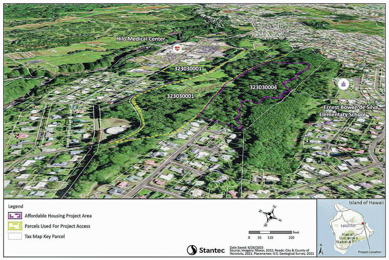
Hawaii County is planning a housing project on almost 61 acres of land it owns near Hilo Benioff Medical Center. A draft environmental assessment calls the ‘Ainako Subdivision Housing Project “a small but meaningful contribution to the significant affordable housing shortage in the local market area.” According to the document — which concluded with an anticipated finding of no significant negative environmental impact in connection with the development — the project will provide “up to 144 residential units” which would be “designed to accommodate the needs of the island workforce and their families.” The consultant who prepared the draft EA was Michelle Lefebvre of Stantec Consulting Services Inc. and Geometrician Associates. The project would be constructed in two phases. Phase one would include construction of the up to 82 townhouses, 28 flats and 34 single-family units on approximately 18.82 acres. The first phase also would include construction of an access road to be named Kalama Street. It would be built on state land to the mauka of Hale ‘Anuenue Restorative Care Center. The multi-family townhouses and flats likely would be lightweight wood-framed construction, according to the document. The subdivision would be organized in clusters of townhouses and flats, with covered parking available at each cluster and on-street parking available for guests. Common areas in the subdivision would include a community center, playgrounds, a volleyball court, a tennis court, gardens and open lawn areas. Phase 1 would likely be built out by a developer under a housing agreement with the county Office of Housing and Community Development. The units would then be offered for sale or rent. The developer would be required to provide management for rentals and property maintenance. Units in the proposed housing project are expected to range in price from approximately $363,100 to $635,500. Infrastructure in the first phase will include clearing and grubbing of the site, which is heavily forested with invasive trees, leading to construction of access and interior two-lane roads with wide shoulders for pedestrian and bicycle travel. County water and sewer infrastructure, overhead electrical, telephone and cable lines, landscaping and possible trails also are planned. A roundabout is currently proposed, but other solutions may be considered during final design. The area was once commonly known as Kaumana Springs due to a surface spring that provided water for Hilo residents until a well in Piihonua that went online in 1973 started providing 3.5 million gallons a day, according to one of the draft EA’s indices. The county Department of Parks and Recreation began developing a master plan for the project area that would convert it into a park. The concept was presented to the County Council in 1970, and state funds for the park were sought two years later. A master plan for the “Kaumana Springs Wilderness Park” was developed, and an EA was conducted in 1976, but the park itself was never constructed, apparently due to lack of funds. One neighbor who lives near the proposed development and opposes its construction — who asked to not be identified by the Tribune-Herald — said the proposed site of the development has what he called “more than 200 important archaeological features” and said most would be destroyed by grubbing and grading for the subdivision. “The property was slated for preservation back in the 1970s due to its historic significance and untouched condition,” the neighbor said. “It appears that only a few people living near the project site presently have knowledge of the project. “Given the project’s impact, we believe that the community at large should be informed.” The draft EA referred to an archaeological inventory survey for the entire project area conducted in 2024. The archaeological fieldwork “identified portions of two previously recorded archaeological sites and two newly identified archaeological sites. A total of 212 archaeological features were identified,” an index stated. Those “discrete features” include mounds and terraces, walls, enclosures and platforms. Some of those archaeological features include various types of water-related infrastructure that were listed as “historic” and “significant, and some were built prior to European contact. “A combination of preservation, historical data recovery and archaeological data recovery are recommended as mitigation for the proposed project effects to the three significant historic properties in the project area,” the draft EA states. The majority of the features in the archaeological survey lie within the footprint of the proposed subdivision. One appendix lists only 25 features being proposed for preservation, which indicates that 187 are recommended for destruction. Of the 25 recommended for preservation, only nine are located in the subdivision’s proposed footprint. That would imply the remaining features will be located among other infrastructure, such as roads. Publication of the draft EA triggered a 30-day public review and comment period that closes Nov. 7. In addition, the OHCD will hold a public meeting to share information and gather feedback from 3 p.m. to 5 p.m. Thursday at the Aupuni Center Conference Room, 101 Pauahi St. in Hilo. “Community members are invited to drop in anytime during the open house-style meeting, which will feature project display boards and opportunities for questions and dialogue with OHCD staff and project team members,” added Kehaulani Costa, the county’s housing administrator. “We want our work to be informed and shaped by the present community and also by those looking to address our community’s future housing needs, particularly with housing that is affordable.” According to Costa, the project was conceived in early 2022. “One of the strategies of the OHCD to expand the availability and affordability of housing on Hawaii Island is to develop publicly owned lands to reduce overall project costs and create opportunities for partnership with experienced nonprofit affordable housing developers,” she said. The current cost estimate for Phase 1 infrastructure construction and installation is $8.538 million. Phase 2 will entail the construction of 35 single--family homes on approximately 15 acres. The planned 15,000- square-foot lots would be graded as individual lots are purchased, rather than all at once. Infrastructure for Phase 2 is similar to that of Phase 1, plus subdivision of the 34 lots. The anticipated price tag is $6.648 million. According to Costa, the projects phases are “to align with the timing and availability of funding.” The draft EA is available online at https://tinyurl.com/4999amje. Public comments can be made online at planning.hawaii.gov/erp/comments/. The OHCD also has established a web page to keep the community updated on the project at 808ne.ws/4qsHxN2. To request an auxiliary aid/service or other accommodation due to a disability for the Oct. 23 meeting, please contact Neil Erickson at neilc.erickson@hawaiicounty.gov at least seven days before the meeting.