Copyright Newsweek
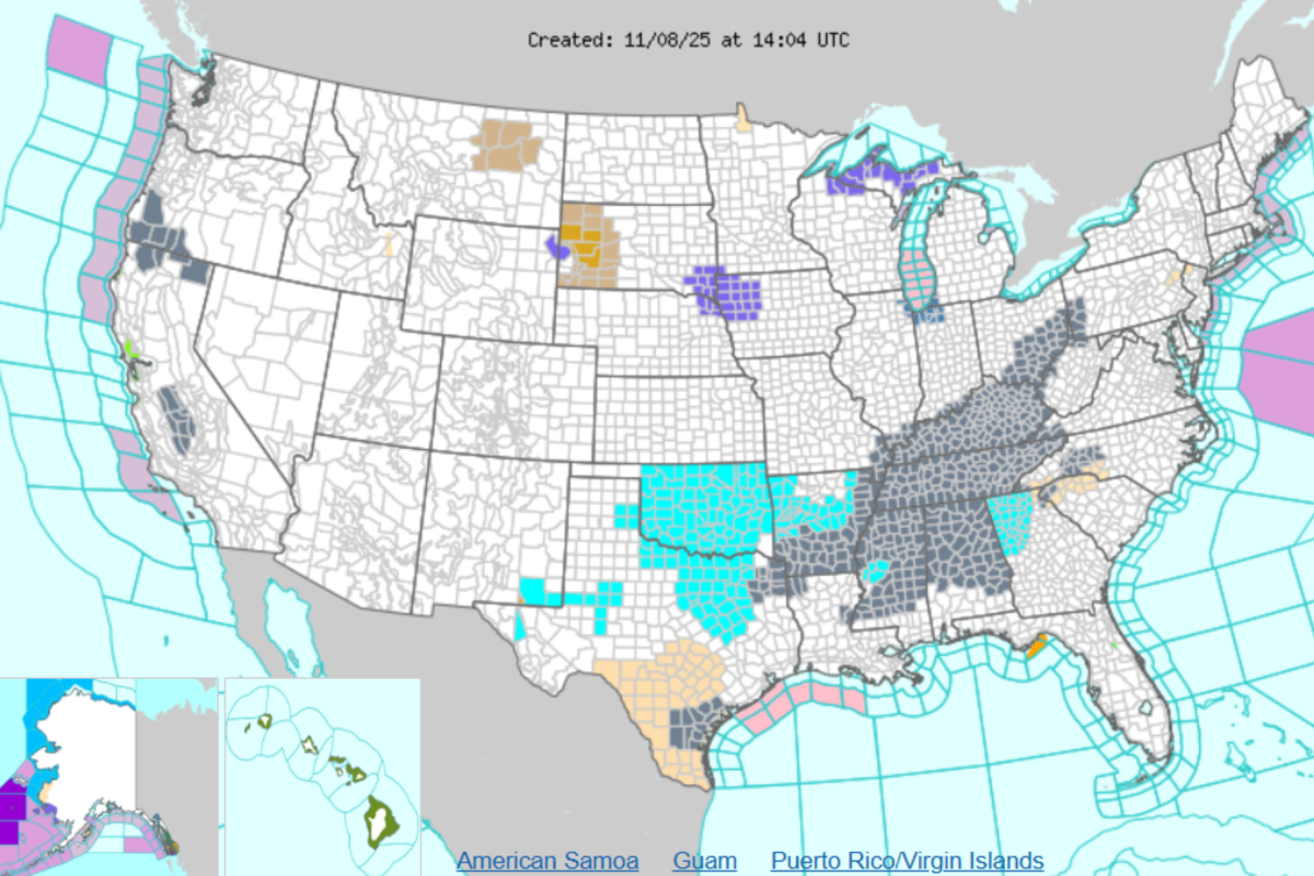
Eight states across the northern and central United States are bracing for severe winter weather this weekend as forecasters from the National Weather Service (NWS) issue warnings for snow, ice, and dangerously cold conditions. Why It Matters The warnings threaten to disrupt daily life, including travel, work, and school, while also posing serious safety risks. Heavy snow and ice can lead to hazardous road conditions, flight cancellations, and power outages, putting residents at risk of accidents and injuries. What To Know In Alaska, the Kuskokwim Delta Coast and Nunivak Island are expected to see blowing snow and strong southeasterly winds from early Sunday morning through the afternoon. Forecasters say up to four inches of snow could accumulate before temperatures rise enough to bring a rain-and-snow mix by midday Sunday. Winds gusting as high as 50 miles per hour will reduce visibility to less than half a mile at times and could bring down tree branches. The NWS said travel in the area “could be very difficult” during the height of the storm. Across the Upper Midwest, snow is falling from northern Iowa into South Dakota, Nebraska, and Minnesota. Advisories remain in effect through midday Saturday, with accumulations generally between 1 and 3 inches. Heavier snowfall is likely between Sioux City and Sioux Falls, while portions of northwest Iowa—including Carroll, Denison, and Emmetsburg—can expect slippery roads and reduced visibility. In the Northern and Wyoming Black Hills, snow totals could reach between 3 and 6 inches, with gusts up to 50 mph creating blowing snow and potentially dangerous driving conditions. Farther east, lake-effect snow is developing around Lake Superior, affecting parts of Wisconsin and Michigan. In Wisconsin, advisories are in place for Vilas, Ashland, and Iron counties from Saturday evening through early Monday where forecasters expect 2 to 8 inches of snow depending on elevation. Northern Michigan is also bracing for heavy accumulation, with the heaviest bands expected across the Upper Peninsula. In Michigan's Upper Peninsula, Marquette, Alger, Gogebic, and Luce counties could see between 4 and 10 inches of snow through Monday, and travel may become difficult or even impossible during periods of intense snowfall. The NWS warned that the hazardous conditions could affect the Monday morning and evening commutes. Forecasters say snow showers and strong winds will continue across the Great Lakes region into early next week before gradually tapering off late Monday. Drivers across the affected states are being urged to slow down, use caution, and check local travel advisories before heading out, as early winter conditions take hold across much of the northern U.S. What People Are Saying NWS Anchorage wrote on X on Saturday morning: "A High Wind Warning is in effect through to 6 AM today. A very strong low pressure system will continue to exit the Western Bering Sea this morning. Winds of 50 to 70 mph with gusts up to 90 mph are possible." NWS Des Moines wrote on X on Saturday morning: "Rain & snow spread across IA today. Snow is most likely across N IA, transitioning to a mix in central IA and rain in S IA. Snow amounts of up to 3" possible in NW Iowa. Light snow lingers into the evening. Road conditions may worsen as temps continue to fall tonight." NWS Sioux Falls wrote on X on Saturday morning: "Snow will continue to move southeast this morning, with colder and breezy conditions this afternoon. Additional snow showers will move south this afternoon but accumulation will be limited." What Happens Next? Local forecast updates are issued by regional NWS branches via the agency’s website and social media channels.