Copyright Newsweek
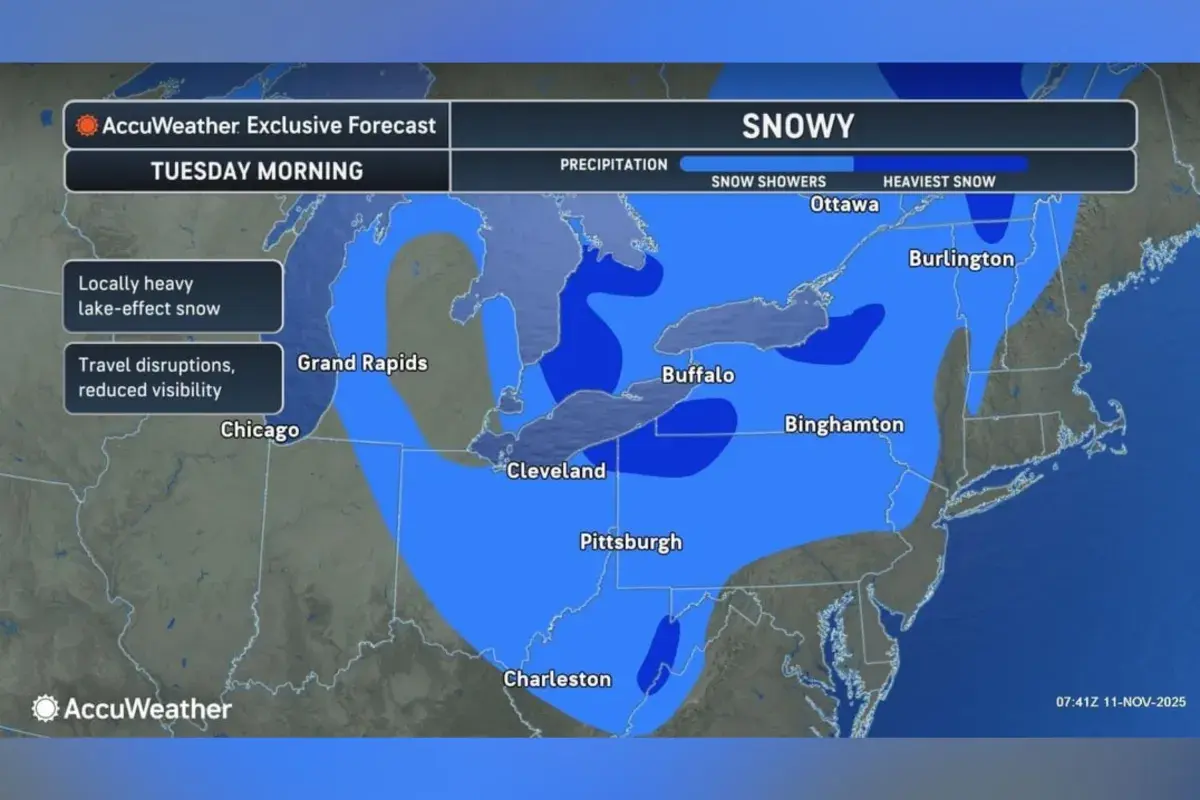
Weather alerts were in effect for several parts of the country as of Tuesday morning, as multiple states have faced snow and plunging temperatures early this week. Why It Matters Much of the eastern U.S. has been facing a major cold snap, and numerous states have been issued weather alerts from the National Weather Service (NWS) amid the difficult travel conditions presented by the inclement weather. What To Know As of reporting, a winter storm warning is in place for West Virginia’s Tucker County—in place until 1 p.m. EST Tuesday—with the NWS warnings that heavy snow could lead to hazardous travel conditions. Winter weather advisories, which are less severe, spanned parts of Ohio, Pennsylvania, New York, and Alaska—where the NWS also warned of snow that presented challenging travel conditions for drivers. The agency has also issued lake-effect snow warnings for Erie, Crawford, Mercer, Venango and Warren Counties in Pennsylvania, as well as Chautauqua County in New York. A snow forecast map for Tuesday morning shared with Newsweek by AccuWeather suggested that the heaviest snowfall totals were expected across northern Vermont, northwest Pennsylvania and an adjoining region of New York, northeast Ohio and eastern West Virginia. It also forecast show showers across portions of Michigan, Indiana, Virginia, Massachusetts, New Hampshire and Maine. Meanwhile, NWS freeze warnings spanned several states across the southern, southeastern, and southwestern U.S. including southeast Arizona and Texas, southern Louisiana and Mississippi, as well as much of Georgia, Alabama and northern Florida. Sub-freezing temperatures in the 20s and 30s were expected across the affected areas, the NWS said, cautioning that actions should be taken to protect tender plants from the cold. What People Are Saying AccuWeather senior meteorologist Matt Benz said, in an advisory shared with Newsweek on Monday: “This early-season wintry blast has been incredibly disruptive. Intense bands of lake-effect snow buried some communities under more than a foot of snow. These conditions are typical in the heart of winter, not in early November. “Snow removal from runways and de-icing delays are compounding challenges at some airports. The combined impacts of scheduled cutbacks to air traffic and wintry weather can have a snowball effect, with more delays and cancellations at airports across the country.” The National Weather Service said in a post on X, Tuesday: “Another day of unseasonably cool weather across the eastern third of the U.S. today, while the western two-thirds will see unseasonably warm readings. The warm temperatures will push further east through mid-week, while cooler readings return to the west by the weekend.” What Happens Next Regular forecast updates are issued by the NWS on its website and via its social media channels.