Copyright thejournal
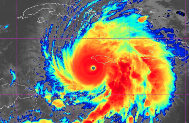
We need your help now Support from readers like you keeps The Journal open. You are visiting us because we have something you value. Independent, unbiased news that tells the truth. Advertising revenue goes some way to support our mission, but this year it has not been enough. If you've seen value in our reporting, please contribute what you can, so we can continue to produce accurate and meaningful journalism. For everyone who needs it. One-off amount I already contribute Sign in. It’s quick, free and it’s up to you. An account is an optional way to support the work we do. Find out more. Investigates Investigates Money Diaries The Journal TV Climate Crisis Cost of Living Road Safety Newsletters Temperature Check Inside the Newsroom The Journal Investigates Daft.ie Property Allianz Home The 42 Sport TG4 Entertainment The Explainer A deep dive into one big news story Sport meets news, current affairs, society & pop culture have your say Or create a free account to join the discussion Advertisement More Stories Radar image showing Hurricane Melissa, a category 5 storm, approaching the southern coast of Jamaica.NOAA Extreme Weather Why is Hurricane Melissa so strong and how will it impact Ireland? Ireland might be in for plenty of rain and unsettled weather. 11.52am, 28 Oct 2025 Share options The Independent / YouTube HURRICANE MELISSA IS the most powerful storm seen anywhere in the world so far this year – something experts are putting down to a warming climate. The remnants of the storm later in the week will likely bring ”plenty of rain and unsettled weather” to Ireland – but it’s too far away to say with certainty yet, according to a meteorologist from Met Éireann. The Grade Five hurricane is to hit Jamaica today and cause catastrophic damage. It’s then expected to hit Cuba, turn north-east and strike the south-east Bahamas by tomorrow evening. A meteorologist from the Irish national forecaster told The Journal that by the time the impact of the hurricane reaches Irish shores, it will have gone through so much change that it will look quite different to what the Caribbean is seeing. “By the time the remnants track across the Atlantic, it could transition into a whole load of things,” the forecaster said. Advertisement Workers board up shop windows ahead of Hurricane Melissa's arrival in Kingston, Jamaica. Prime minister Andrew Holness said: “There is no infrastructure in the region that can withstand a category five.Alamy Stock Photo Alamy Stock Photo “It could end up being almost nothing by the time it gets to us. You could never say with certainty what we will expect.” He said that when hurricanes in the Caribbean move northwards, the cold sea causes them to weaken, and the interaction with different weather systems change the nature of the storm. “Plenty of our weather comes from transitioning from ex-hurricanes. We get the remnants all the time and that’s not unusual,” he said. Climate change impact The hurricane will be the most powerful to hit Jamaica since records began 174 years ago. It jumped from a tropical storm with 110 km/h winds to a 225km/h winds Category Four within 24 hours. It’s since strengthened further into a Category Five, the highest level on the Saffir-Simpson scale, which means even well-built structures face catastrophic damage. The US National Hurricane Centre has warned that “catastrophic winds, flash flooding and storm surge” are expected in Jamaica, while the International Red Cross said the storm could impact up to 1.5 million people in Jamaica. But why is it so strong? Related Reads Hurricane Melissa to batter Jamaica as the island’s strongest storm on record Satellite image showing Hurricane Melissa, a category 5 storm, approaching the southern coast of Jamaica.Alamy Stock Photo Alamy Stock Photo Atmospheric scientist Daniel Gilford of non-profit organisation Climate Central said that when sea surface temperatures become warmer, they inject more energy into storms, making them more intense. The storm passed over waters 1.4 degrees Celsius warmer than average for this time of year due to climate change, according to an analysis from Climate Central. The non-profit said that these temperatures were at least 500 times more likely due to human-caused warming. Warmer oceans also mean wetter storms. “We expect something like between 25-50 percent extra rainfall in a storm like Melissa because of human-caused climate change,” said Gilford. Jill Trepanier, a hurricane climatology expert at Louisiana State University, said that the impact of climate change is making this hurricane particularly “terrifying”. The hurricane is a slow moving type of storm called a stalling storm. Normally stalling storms tend to die out as they pull up cold water from the depths of the ocean and are exposed to wavy, up-and-down winds in the atmosphere tearing them apart. But this hurricane intensified instead as the water was so warm, and the warmth ran so deep that it avoided the usual self-destructing effect. With additional reporting from AFP Readers like you are keeping these stories free for everyone... A mix of advertising and supporting contributions helps keep paywalls away from valuable information like this article. Over 5,000 readers like you have already stepped up and support us with a monthly payment or a once-off donation. Support The Journal The Journal's climate change newsletter Follow the biggest news story of our times. Sign up for our monthly climate newsletter You are now signed up Sophie Finn View 7 comments Send Tip or Correction Embed this post To embed this post, copy the code below on your site Email “Why is Hurricane Melissa so strong and how will it impact Ireland?”. Recipient's Email Feedback on “Why is Hurricane Melissa so strong and how will it impact Ireland?”. Your Feedback Your Email (optional) Report a Comment Please select the reason for reporting this comment. Please give full details of the problem with the comment... This is YOUR comments community. Stay civil, stay constructive, stay on topic. Please familiarise yourself with our comments policy before taking part. Leave a Comment Submit a report Please help us understand how this comment violates our community guidelines. Damaging the good reputation of someone, slander, or libel. Racism or Hate speech An attack on an individual or group based on religion, race, gender, or beliefs. Trolling or Off-topic An attempt to derail the discussion. Inappropriate language Profanity, obscenity, vulgarity, or slurs. Advertising, phishing, scamming, bots, or repetitive posts. Please provide additional information Thank you for the feedback Your feedback has been sent to our team for review. Leave a commentcancel Newly created accounts can only comment using The Journal app. This is to add an extra layer of security to account creation. Download and sign into the app to continue. Access to the comments facility has been disabled for this user View our policy ⚠️ Duplicate comment Post Comment have your say Or create a free account to join the discussion Climate Change CLIMATE CRISIS Extreme Weather Extreme Weather Event Hurricane melissa Met Éireann forecast News in 60 seconds by-election time Runners and riders: Connolly's on her way to the Áras - so who might fill her Dáil seat? Prince Andrew Prince Andrew hosted Jeffrey Epstein at his Windsor home just days before his arrest in Florida 19 mins ago 'Misleading, divisive and self-serving' - Celtic owner Dermot Desmond takes aim at Brendan Rodgers St James’s Hospital President Higgins spends second night in hospital as he receives treatment for infection The Daily Poll How long do you think Micheál Martin will remain as Fianna Fáil leader? your stories Did you spoil your vote in the presidential election? We want to hear why An tOireachtas Cliabhán Kneecap is Harland & Wolff, Béal Feirste, ag cur fáilte roimh Oireachtas na Gaeilge A man has been arrested after he barricaded himself inside an empty creche in County Meath North Strand Road Man charged with assault and public order offences after Connolly canvasser incident Oliver Plunkett Street Gardaí launch investigation into attacks on drag artists in Cork city by-election time Runners and riders: Connolly's on her way to the Áras - so who might fill her Dáil seat? more from us Investigates Money Diaries The Journal TV Journal Media Advertise With Us About FactCheck Our Network FactCheck Knowledge Bank Terms & Legal Notices Terms of Use Cookies & Privacy Advertising Competition more from us TV Listings GAA Fixtures The Video Review Journal Media Advertise With Us Our Network The Journal FactCheck Knowledge Bank Terms & Legal Notices Terms of Use Cookies & Privacy Advertising Competition © 2025 Journal Media Ltd Terms of Use Cookies & Privacy Advertising Competition Switch to Desktop Switch to Mobile The Journal supports the work of the Press Council of Ireland and the Office of the Press Ombudsman, and our staff operate within the Code of Practice. You can obtain a copy of the Code, or contact the Council, at https://www.presscouncil.ie, PH: (01) 6489130, Lo-Call 1800 208 080 or email: mailto:info@presscouncil.ie Report an error, omission or problem: Your Email (optional) Create Email Alert Create an email alert based on the current article Email Address One email every morning As soon as new articles come online