By Astha Saxena,Chiara Fiorillo
Copyright mirror
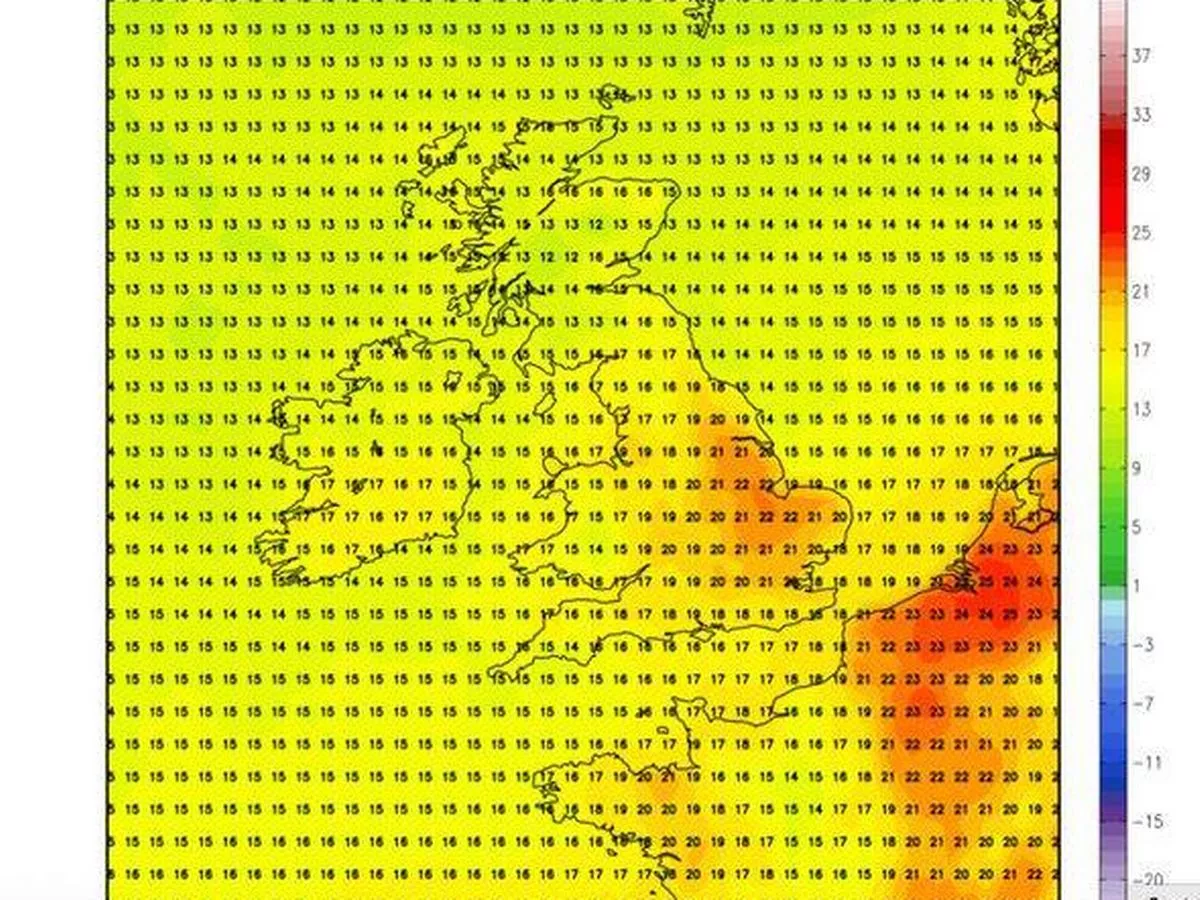
Swathes of Britain are poised to bask in scorching conditions as new weather charts reveal temperatures could rocket to 22C in the coming days. Forecasting maps from Netweather.tv indicate that balmy weather will sweep back across the nation before September draws to a close. The charts for September 29 reveal that regions around Norwich, Peterborough, Cambridge and Norfolk will bear the brunt of the heat as mercury levels climb to 22C. Meanwhile, other locations including London, Luton, Oxford, Reading, Northampton, Gloucester and Coventry will experience highs of 21C. Areas around Bristol, Bath and Stratford upon Avon are forecast to see temperatures fluctuating between 19C and 20C, according to the projections. The mild conditions are expected to persist even across Scotland , reports the Express . Weather charts suggest that zones around Edinburgh, Glasgow, Aberdeen, Perth and Dundee will also witness double-digit temperatures, potentially reaching 14C to 15C. This dramatic weather turnaround arrives just days after the Met Office issued a yellow warning for rain and wind across Wales and parts of England this weekend. Met Office Chief Meteorologist, Matthew Lehnert, said: “Through this period, 20-30mm of rain is expected to fall widely across Wales and northern England, with some locations perhaps seeing 60-80mm. Where these higher rainfall amounts fall remains uncertain and it is possible that this warning may be updated if confidence increases, particularly if the heaviest rain falls in urban areas.” The Met Office has forecasted that settled conditions will prevail across the country as we head into next week. The majority of areas are set to dry out, although Scotland’s far north could see more cloud and rain on Monday, and showers may persist in south-east Kent until mid-week, it said. Its long-range forecast from September 24 to October 3 states: “High pressure will dominate across many parts of the UK at first, leading to widely settled conditions and some patchy frost and fog at night. The main exception initially will be in East Anglia and southeast England, where showers will be possible, accompanied by a brisk breeze at times. “These may ease later in the week, as low pressure over the North Atlantic attempts to push some cloud and patchy rain towards western and northwestern parts of the UK. Temperatures should gradually return closer to average. By early October, confidence in the overall weather patterns affecting the UK is very low, and whilst it may turn more changeable, the wettest conditions are most likely towards the west and northwest.” Cities including Norwich, Peterborough, Cambridge, Norfolk, London, Luton, Oxford, Reading, Northampton, Gloucester, Coventry, Bristol, Bath, and Stratford upon Avon can expect these conditions.