By Reverend A. Anglade
Copyright thehindu
In the early 1910s, the road to Kodaikanal was a work in progress. Workers were widening the bridle path formed in 1878 to reach the star-shaped lake formed by the then Collector of Madurai, Sir Vere Henry Levinge, in 1863. For the British, the hills and their salubrious climate offered a respite from the wilting heat of the plains. The workers were toiling to complete a motorable road envisaged by Major G.C. Law. But for the earliest recorder of the dolmens of Kodaikanal, Father A. Anglade, it was a period of anxiety and suspense. The road was completed in 1914 and opened by 1916. But even before the road was laid, using the bridle path, a dirt road used by the Paliyar tribes, Jesuit priests had gone up the hills to found the Sacred Heart College at Shembaganur in 1895.
The first survey
This seminary, a monastic place for meditation and rejuvenation of the spirit, also allowed Jesuit priests to indulge in their passion for biology and history. It was here — where the only sounds were the chirping of birds, the soft whisper of rain, or, on long nights, the loud buzz of cicadas carried by a cool breeze — that Reverend A. Anglade S.J. and Reverend L. V. Newton S.J. wrote The Dolmens of the Pulney Hills, a work later compiled in the 1928 edition of Memoirs of the Archaeological Survey of India.
The work was seen as a pressing need by the Fathers. As it was said, “The destruction still goes on near the villages and along the roads. The best group of the dolmens of Machur near the Forest Bungalow at a sharp turn of the ghat road, and a little beyond the 18th milestone, was greatly damaged by the road-makers some years ago and use is being made of what remains to repair walls and culverts whenever there is need, which is rather often.”
Along with the Paliyar men, Father Anglade, also a well-known botanist, and Father Newton may have traversed the dips and hollows of the hills, recording the dolmens and the rich flora and fauna of this unique region. Struck by the numerous dolmens scattered in these crevices and a pattern, they started the first survey of the dolmens in the hills.
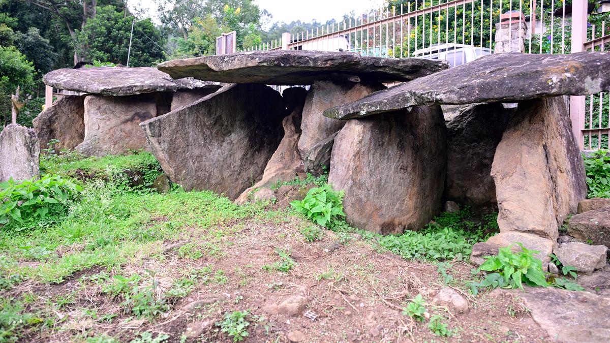
The dolmens, which are megalithic structures, could be dated to beyond 5,000 years. Father Anglade writes, “From the present site and position of the dolmens and from the rough materials seen close by…it is comparatively easy to form an idea of the process of construction. Neither on the stones used for the wall nor on the slabs of the chambers is there any mark of cutting or dressing with any instrument.”
He imagines that maybe the chief of the tribe chose a particular spot to build the dolmens and the number of chambers was determined according to the number of slabs available in the immediate vicinity with the size depending on the actual dimensions of the slabs. The builders would have been entirely dependent on the natural quarries nearby. As a result, in Kodaikanal, most of the dolmens are invariably erected on rocky ridges or slopes or immediately below a large expanse of rock. Even today, at some of the sites, one can see slabs of various dimensions lying detached from the surface of the rock owing to the vagaries of nature.
Another interesting observation made by these early archaeologists was that the large cap-stone that was placed on top of the four vertical slabs had a gentle slope. This led rainwater to flow away from the dolmens. The dolmens also had an opening at the lower end to prevent rainwater from accumulating in the chambers.
A research paper written by R. N. Kumaran and M. Saranya, ‘(Pre) Iron Age Burials of Thandikudi, Tamil Nadu’, in 2015 says Thandikudi was well connected by major traditional trade routes. “One of the trade routes that connects Musiri on the West Coast and Madurai in the hinterland passes through Pollachi, Palani, Dindgul, and Madurai. The villages — Palamalai, Perumalmalai, Machhur, Pannaikadu, Thandikudi and Kadavumalai — were on this trade route,” the paper says. And the early records of dolmens, cists, urns, and cairn-circles are found on this route. This showcases the density of the population that had resided in these hills so many centuries before the early Pandya period when the trade routes had been established.
In another work, Archaeological Investigations at Thandikudi, by K. Rajan, N. Athiyaman, VP Yatees Kumar, and M. Saranya in 2008, it is said the terrain may have played a great role for the early inhabitants of the region. “Nearly 90% of the archaeological sites of this region fall within the range of 4000-5000 feet above mean sea level. This altitude provides a congenial environment for the growth of forest products like pepper and cardamom,” the article says. For the forest-gatherers of the bygone days, this may have been one of the reasons to inhabit tracts in this altitude.
Occupation from pre-Iron Age
In 2004, the first phase of excavation was done in the burial site that occupies about 40 hectares on the right bank of the Marudanadhi. It extends along the right bank, starting from the Forest Bungalow on the west to Bommakadu on the east. From artefacts such as black and red ware and beads of carnelian that have been excavated from some of these megalithic structures, the archaeologists infer that the pre-Iron Age graves may have been located at the highest point of the burial complex that would have been just opposite the habitation mound on the other bank. And as the burial complex grew over the years, the graves moved progressively away from the habitation. The explorations by the Jesuit Fathers and the subsequent excavations carried out in the pepper and cardamom plantations in the lower Palani hills reveal continuous occupation from the pre-Iron Age to the present day.
At Pethuparai near Perumal Malai, one can see on a gently sloping ridge, dolmens that have been fenced by the Archaeological Survey of India (ASI). At Thandikudi, the dolmens are vanishing, and some have slowly disappeared under thick vegetation. It may have been a premonition of Father Anglade when he writes in his work, “Out of the three groups near Neutral Saddle, at the foot of Perumal Malai, the smallest one was completely destroyed…and another greatly damaged in May 1925. If such destruction can take place in our days and under our eyes, it needs no special gift of prophecy to foresee that before long not a single stone along the public road and within the reach of contractors and their coolies will escape their ravages.”
Lobbo Christian, who works at Sacred Heart College digitising the numerous old records, fears that the prophecy may come true as only less than 50% of the dolmens, recorded by the Jesuit Fathers, can be seen precariously standing in these hills, revealing the crucial role this region played in the ancient history of Tamil Nadu.