By Anwar Siswadi kontributor
Copyright tempo
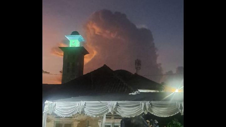
TEMPO.CO, Jakarta – A cluster of lightning-filled clouds visible to residents in Bandung and Garut on Monday evening, September 22, 2025, has sparked concern and speculation about a potential major disaster. Social media narratives have speculated about the eruption of Mount Guntur in Garut, while others have connected the phenomenon to other imminent catastrophes.The West Java Meteorology, Climatology, and Geophysics Agency (BMKG) promptly issued a statement to debunk these rumors, confirming that they are hoaxes. “Lightning within clouds is a natural phenomenon caused by electrical activity within cumulonimbus clouds,” a BMKG forecaster for West Java stated in a press release.Teguh Rahayu, the Head of BMKG Bandung’s Geophysics Station, stated that cumulonimbus clouds (Cb) have several subtypes distinguished by their peak shape and visual characteristics. Based on photos received by the agency, the lightning-filled clouds seen yesterday had a high, broad top resembling a mushroom cap with a dark base.He identified such clouds as a variety of anvil cumulonimbus (Cb incus). “Scientifically, this type of cloud is highly likely to produce heavy rain, strong winds, lightning, and even storms,” he told Tempo.According to BMKG, lightning within clouds occurs due to the accumulation and difference in electric charges inside storm clouds. Positively charged ice crystals are carried to the top, while heavier, negatively charged water and ice particles gather at the bottom. This imbalance triggers the release of electrical energy, creating a flash of light known as intra-cloud lightning or sheet lightning.The phenomenon, captured by residents and circulated on social media, was observed in the western part of the sky as the sun set. Weather satellite data detected cumulonimbus clouds forming west of Bandung in the Bogor region and moving toward the Banten border. Subsequently, cumulonimbus clouds also appeared in Sukabumi.Such atmospheric conditions indicate relatively high convective activity in the central to western regions of West Java. Rahayu emphasized that cumulonimbus clouds require monitoring due to their potential to cause heavy rain, strong winds, and lightning. This was evidenced by the simultaneous occurrence of heavy rain in the Bogor region.Editor’s Choice: Why Is Indonesia’s Rainy Season Starting Early in 2025?Click here to get the latest news updates from Tempo on Google News