Copyright Anchorage Daily News
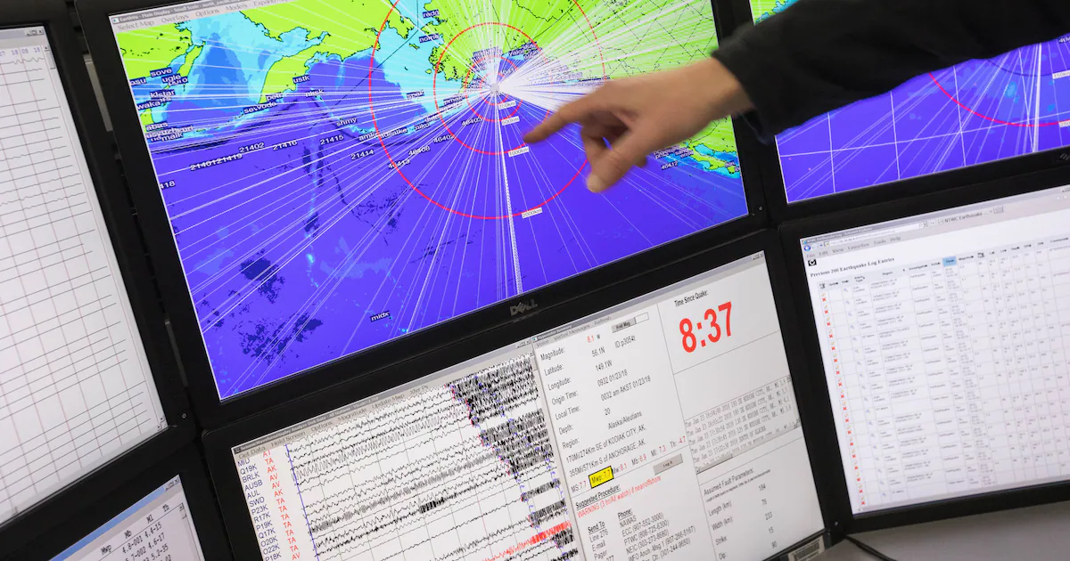
After surging through the Pacific Ocean, a massive tsunami crashed into Hawaii in 1946, killing 159 people and destroying hundreds of buildings. It was the deadliest such event in modern U.S. history - and it sparked a reckoning. The wave was caused by a distant underwater earthquake near Alaska’s Aleutian Islands. Few in Hawaii knew the deadly tremor had occurred, or that a massive wall of water that reached as high as 130 feet, was on its way, moving as fast as a commercial jet. The disaster, along with another earthquake-caused tsunami in 1964, pushed the United States to beef up its alert systems in part through the National Tsunami Warning Center, operated under National Oceanic and Atmospheric Administration, and track seismic activity in that remote area, an earthquake hot spot. Those observations are now at risk. After NOAA ceased funding to the lab that’s been monitoring seismic activity for more than 25 years, nine stations tracking tsunami-causing earthquakes for the agency will go offline by the end of the month. Michael West, director of the Alaska Earthquake Center and the state’s seismologist, contacted NOAA on Sept. 23 asking if the expected Oct. 1 federal funding of about $300,000 would come through. He was told a week later - one day before the deadline - that the agency would not be able to continue the grant this year, according to documents reviewed by The Washington Post, citing a lack of available funding. While NOAA says the funding ended in FY 2024, the AEC says they weren’t informed of this and hadn’t been informed of any lapse in funding until September. Meanwhile, AEC says they did receive money they were able to use for 2025. “The AEC is one of many partners supporting the National Weather Service’s tsunami operations, and NWS continues to use many mechanisms to ensure the collection of seismic data across the state of Alaska,” NOAA spokeswoman Kim Doster told The Post in a statement. The lack of funding could have widespread repercussions for the entire Pacific coast and poses safety concerns for remote communities living on these Alaskan islands who rely on the speedy warnings made possible from this data, according to local leaders and seismologists. As part of its mission to understand and predict changes to the weather and the oceans, NOAA typically alerts a tsunami within five minutes of an earthquake - a task that will be more challenging as the sensors go dark. The termination, current and former NOAA employees said, is also the latest in a series of staffing and funding cuts that have eroded the government’s ability to precisely gather and assess scientific data - which could have yet unknown long-term consequences. “It’s not something you see in the impact right away,” said a senior NOAA official who spoke on the condition of anonymity because they were not authorized to speak to the media. “You see it in the slow degradation in the quality of the data.” Staffing cuts that have reduced the number of federal meteorologists have curbed the amount of weather balloons launched each day. Certain satellite observations that track extreme weather have been scrapped. And now the ability to collect and respond to data critical for tsunami warnings will also be impeded. “The system doesn’t collapse if you lose one measurement,” said the senior official. “But it creates holes in the network of observations.” An earthquake-caused tsunami heading for Hawaii could eventually be picked up, but maybe 20 minutes later, the official noted. And when it comes to tsunamis, seconds matter. Remote seismic sensors The Alaska Earthquake Center, part of the University of Alaska at Fairbanks, monitors the most seismically active region in the country. That includes the Aleutians, where the Pacific tectonic plate is pushing under the North American plate, and has been for more than 100 million years. The movement can displace huge volumes of ocean water, creating massive waves, or, tsunamis. This year, the center has reported more than 24,600 earthquakes, thanks in part to high-tech transmitters sheltered inside heavy-duty huts across some of the state’s most remote corners. The seismometers themselves, about the size of a coffee can, are buried deep into the ground so they can ideally pick up only the movement of the earth and less the shaking of, say, a passing car. The wiggles coming from the instruments are transmitted to NOAA’s National Tsunami Warning Center within seconds. They can be analyzed to assess the size and shape of the earthquake and whether it’s out in the ocean. “There has been a long understanding across federal agencies and state agencies that Alaska needs a strong seismic monitoring system,” West said. He said that while Alaska experiences frequent tremors, tsunami risks usually emerge from magnitude 7 or greater earthquakes, which happen on average at least once a year. Then, speed is of the essence. “Communities nearby need to be warned as soon as possible,” said Jackie Caplan-Auerbach, a geophysicist, whose research includes earthquakes, at Western Washington University. “Any kind of reduction to these stations that are remote and don’t have a lot of infrastructure has a potential to be really damaging to the response.” Local governments, which have done their best to adapt to these risks, expressed disappointment at the potential lag. “It’s frustrating,” said Tina Ryman, the Borough Manager of Yakutat, a vast region in Southeast Alaska that experiences frequent earthquakes. The small fishing village where most people live has tsunami sirens and runs evacuation drills regularly so residents can become familiar with the paths to higher ground. “But if we can’t count on accurate predictions of tsunami patterns, all that stuff becomes useless,” said Ryman. It’s not the first time the remote settlement has felt the effects of funding cuts this year. Yakutat lost its sole National Weather Service employee as well, Ryman said, meaning no weather balloons fly over the sparsely populated expanse. “Without proper weather observations,” Ryman said, “life in Alaska in general just becomes much more dangerous.” A wide reach The dearth of earthquake data could be a broader problem across the Pacific too, seismologists across the country said. It can take about five hours for a tsunami wave to travel from Alaska to Hawaii. In that time, data from the initial event is necessary to predict its height, speed and direction, said Harold Tobin, state seismologist for Washington and the director of the Pacific Northwest’s seismic network. In July, an 8.8 magnitude earthquake - one of the largest ever recorded - off the coast of Russia prompted tsunami warnings from Alaska to Hawaii and California, as well as widespread evacuations. The ensuing tsunamis were smaller than anticipated, but served as a sobering reminder of potential threat. The Alaska sensors soon to go offline were among the closest to the rupture, said West. “The clarity of the warning emerges as the tsunami travels across the ocean,” said Tobin. “And so slowing that process down or making more uncertainty especially in how big the earthquake was and exactly where the source was makes a big difference.” The move to cut off the Alaska center was troubling, he added, and reminded him of his own precarious relationship with the federal government. Tobin’s earthquake center shares its data with NOAA and the U.S. Geological Survey, which has also fallen victim to Trump administration cuts. “This could be a canary in a coal mine sign that other agencies will lose more funding,” he said. But at a time of overall cost-cutting, it might be hard to vouch for funding to stave off extreme yet relatively rare risks, the senior NOAA official said. “It’s a high-impact low-probability event,” they said. “And they would favor the high-probability moderate-impact events.” NOAA’s global tsunami database has recorded more than 2,400 tsunamis since 2100 B.C. “It’s not like it’s hypothetical,” Tobin said. “This has happened multiple times in the last 100 years and it will happen again.”