The trail to the base of Amin Brakk, a great wedge of vertical rock that’s earned comparisons to El Capitan, doesn’t so much start as the community slips away—up from the barley fields of Kanday village, past apricot trees and rock-walled potato plots, into terrain that gets a bit steeper and stonier with every step.
We’re bound for the end of the Nangma Valley, a roughly 16-mile trail that terminates in a glacial cul-de-sac rimmed with sky-piercing spires of granite (some unnamed, many unclimbed, and most over 16,000 feet tall) in Pakistan’s Karakoram Mountains.
We were not, thankfully, attempting to summit them. Our ambitions were simpler: A four-day trek to its base and back, with enough time to linger over tea next to rivers the color of polished slate, trace the arc of avalanches tumbling down far-off peaks, and move through a landscape still largely untouched by tourism.
For decades, trekking in Pakistan has been synonymous with K2. As the second-tallest mountain worldwide, it has long drawn elite climbers to its glaciated flanks, where reaching the summit requires permits, porters, and advanced alpine skill. But beyond the shadow of the Karakoram’s most famous peak lies a vast and under-explored network of trails, including alpine valleys shaped by glaciers, summer pastures used by herders for generations, and granite-walled corridors like Nangma that remain largely unknown outside the climbing world.
That obscurity is beginning to fade. Pakistan’s newly free e-visa system, expanded domestic flight network, and improved security in the northern regions have made once-daunting logistics far more manageable. At the same time, international outfitters like Intrepid Travel have begun offering guided, fully supported (with porters, cooks, and camping gear) hiking trips, bringing the Karakoram onto the radar of more casual trekkers.
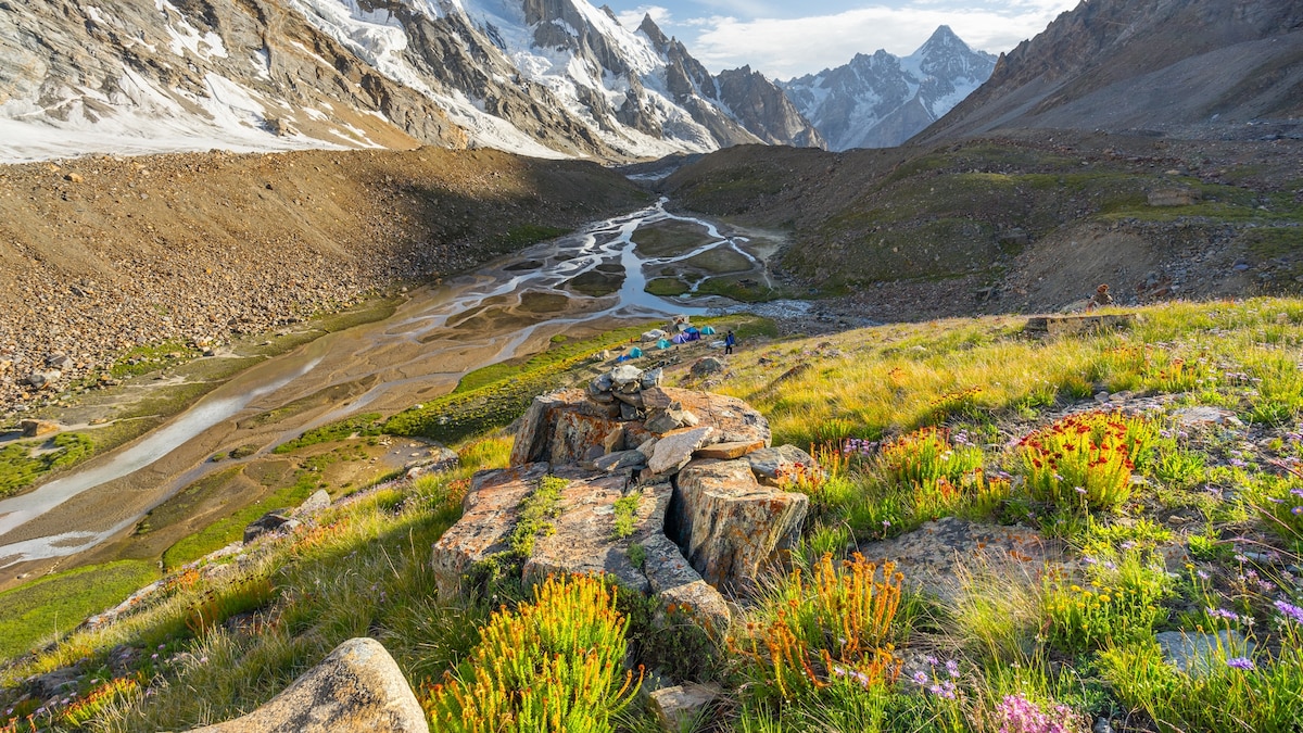
During my trip into the Nangma Valley, the trail revealed itself in layers. It began as a gentle path winding past potato plots and apricot orchards, where children waved from stone-walled fields, then climbed into alpine meadows grazed by goats and scattered with wildflowers. Higher still, the landscape shifted to moraine and granite, with simple log bridges spanning braided rivers spilling cold and quick from the glaciers above. By the time you reach base camp, the valley floor levels into a broad plain of boulders and grass, edged by sheer granite walls and overlooked by glaciers that creak and calve in the afternoon sun. It was in that thyme-scented meadow dimpled with the faint hoof prints of pasture-raised cows that we set up camp in the late afternoon. As the sun sank, the walls around us flared orange, glowing like cathedral windows. Then the stars came in absurd abundance, flung across the sky with theatrical generosity.
There was grandeur in spades. And silence. And the feeling—rarer than it should be—that you had, for a brief moment, wandered somewhere entirely unspoiled.
Beyond Nangma: Where else to hike in Pakistan
Pakistan, long overshadowed by neighboring trekking giants like Nepal and India, is experiencing a slow but steady revival of international trekking interest. New infrastructure and a wave of homegrown adventure tourism startups have opened access to trails that were once considered challenging to reach.
The Karakoram Highway snakes through Gilgit-Baltistan and acts as the spine for countless side treks, from the gentler routes of Hunza to the high-altitude expeditions of the upper Baltoro. Here are just a few to consider beyond the Nangma Valley.
(6 of the world’s most remote destinations to test your inner adventurer)
Best hikes for beginners
Ondra Poygah hike
Set in the Hunza Valley, this moderate day hike blends sweeping alpine vistas with centuries of cultural history. The mile-long stone staircase—1,655 steps in total, the longest and highest in Pakistan—leads to Ondra Fort, perched above Gulmit village. There, hikers are rewarded with commanding views of the Karakoram peaks and the aquamarine Hunza River snaking through the valley floor. Along the way, apricot orchards and remnants of Silk Road watchtowers anchor the hike in the region’s layered past.
Passu Glacier hike
The Passu Glacier Hike is a half-day excursion that begins near Passu village, threading through apricot orchards and over suspension bridges before climbing onto the glacier’s lateral moraine. Gravel ridges and icy streams demand careful footing, but the payoff of the roughly four-mile hike each way is immense: A direct view of the stark white Passu Glacier framed by the serrated Passu Cones and Shispare Peak.
(Our ancestors walked these trails hundreds of years ago. Now you can too.)
Challenging and multi-day treks
Masterbrum Base Camp
The Masherbrum Base Camp trek is one of Baltistan’s most accessible multi-day hikes, typically completed in about five days round-trip. Beginning in Hushe village, the trail follows the Hushe River past wheat fields and stone houses before opening into broad alpine valleys. The first night is usually spent at Shaieshcho camp, a grassy flat where herders graze their animals. From there, it’s a steady but manageable climb along the Masherbrum Glacier to reach base camp at roughly 14,000 feet. Here, Masherbrum—also known as K1—rises in a perfect white pyramid to 25,659 feet. Unlike the grueling expeditions to K2 or Concordia, this hike is low on technical difficulty but high on reward, offering intimate glimpses of village life alongside commanding views of one of the Karakoram’s most spectacular summits.
Rakaposhi Base Camp
From the village of Minapin, a 7.7-mile trail to Rakposhi Base Camp ascends through juniper forests and wildflower meadows to a broad, windswept plateau at 12,000 feet. The climb takes two to three days, with Hapakun, a grassy field, serving as a midway campsite. At the top, trekkers stand before the 25,551-foot summit of Rakaposhi, one of the world’s greatest mountain reliefs, and can explore side trails along the Minapin Glacier before returning.
K2 Base Camp
The K2 Base Camp trek is Pakistan’s most legendary hike, a high-altitude, two- to three-week expedition that begins in Askole and traces the Braldu River into the icy heart of the Karakoram. The route follows the Baltoro Glacier (one of the largest outside the polar regions) past storied camps like Paiju and Urdukas before reaching Concordia, where four of the world’s 14 highest peaks ring the horizon. From here it’s a final push to base camp at about 16,900 feet, directly beneath K2’s towering south face. It’s a route that’s incredibly remote and logistically complex—but for seasoned trekkers, few places on Earth are more awe-inspiring.