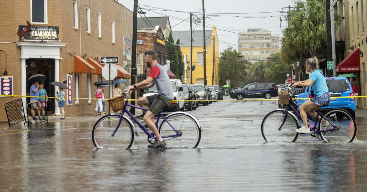
CHARLESTON — These days, all it takes is a high tide to send water into the streets of the peninsula. When it’s a king tide because the sun and moon align just so and exert a stronger-than-usual pull on the seas, the so-called nuisance flooding gets worse.
Add some heavy rain to the formula and the container spills over. Flooding is more than a mere nuisance; it becomes dangerous. Vehicles get stuck. School kids wade through knee-deep, bacteria-infested storm water. Invisible potholes and drainage pipe openings ambush passersby.
And flooding is hardly limited to the low-lying peninsula. Areas of West Ashley, James Island, Johns Island, Daniel Island, Mount Pleasant, Kiawah Island, Sullivan’s Island and Isle of Palms all can see accumulations of water in places where no water should accumulate.
One obvious reason this is happening more frequently is sea-level rise. As the globe warms because of human-induced climate change, its oceans swell. H2O molecules in warm water spread out, causing our seas to expand in volume. What’s more, heat in the polar regions cause accelerated melting of glaciers and ice caps, which add more volume and push water levels higher overall.
When the Thwaites Glacier in western Antarctica breaks away — which could happen all at once within a few decades, or incrementally, according to the latest science — average global sea levels will rise significantly.
If the glacier suddenly collapses, it could add 25 inches to the world’s oceans, on average, and it would remove a barrier that minimizes additional melting inside the polar continent, according to recent research. Eventually, when all the Thwaites melting is done, the oceans could be about 10 feet higher than they are today.
And that’s after sea level rise caused by other forces. The waters around Charleston are predicted to rise about one foot by 2050 due to other forces of climate change.
That’s the grand view. What does it look like at ground level in Charleston? Bad.
The average elevation of the peninsula is perhaps eight feet. A full third of all residential properties are located on land that is 10 feet or less above sea level — which means more than an impermeable sea wall will be needed to protect much of the city.
In the 1990s, Charleston experienced 10-25 nuisance flooding events annually. In recent years, the number of days per year when tidal flooding soaks the city can exceed 80.
And get this: as the water rises, a lot of the land sinks.
That’s because at least 40 percent of the peninsula’s terra firma is landfill — marshes and creeks stuffed with garbage, dredging materials, dirt and sand. Don’t call that solid ground, even though structures have been built upon it, because it’s settling and, in places, eroding. The water remembers it’s old pathways and find a way in.
That’s why certain places flood regularly and significantly: Hagood and Fishburne streets and Lockwood Boulevard on the West Side; the hospital district just south of that; stretches of East Bay Street and parts of the East Side neighborhood. Those areas are paved now, but they used to be marsh and creeks.
So sea levels rise while the land subsides, a process that has been accelerating with increased use of fossil fuels.
If nothing is done, most of the peninsula’s west side, and a good portion of its east side — will be under water permanently by 2060. These are the areas that were filled and bulldozed flat over the centuries. The high “spine” of the peninsula, along King and Meetings streets, currently is 13 feet above sea level, at most, according to the U.S. Geological Survey. That number will steadily drop.
Imagine, then, what a significant storm surge from a hurricane will do. Or a rain bomb at high tide.
The good news, if you want to call it that, is that solutions exist. We still have control over certain things: where we build, what structures we build, how we assemble and equip those structures, what fuels we use, whether we prioritize conservation and restoration. We can adopt best practices in urban design and planning and green technologies. And we can adapt in creative ways to our waterworld, even leveraging the rising tide as a force for productive change and long-term survival.