By Editor,Stacy Liberatore
Copyright dailymail
Super typhoon’s shockwaves to unleash chaos on the US West Coast in just DAYS
READ MORE: Hurricane Priscilla eyes six US states in its ‘cone of uncertainty’
By STACY LIBERATORE, US SCIENCE & TECHNOLOGY EDITOR
Published: 14:20 BST, 9 October 2025 | Updated: 14:23 BST, 9 October 2025
A super typhoon that skirted Japan this week is expected to send ripples across the Pacific, potentially fueling a week of turbulent weather in the western US.
While Typhoon Halong spared Tokyo from what would have been the equivalent of a Category 4 hurricane, meteorologists have warned that its remnants could help drive heavy rain and snow in California by early next week.
As it moves into the North Pacific, the fast-moving jet stream is expected to absorb the typhoon’s energy, intensifying storms along the storm track.
This phenomenon, caused by ‘recurving typhoons,’ can send far-reaching effects across the ocean.
Forecasts indicated that remnants of the typhoon could generate hurricane-force winds in Alaska’s Bering Sea this weekend, which the National Weather Service (NWS) said is reminiscent of the 2022 typhoon Merbok that caused millions of dollars in damage across the western region of the state.
But the potential impact on the continental US is what has forecasters watching closely.
The energy from Halong is expected to move a high-pressure system into Canada, pushing subarctic air southward into Washington, Oregon and California by Monday.
If a storm moving down the coast coincides with this cold air, Northern California could see significant rainfall in the Bay Area and several feet of snow in the Sierra Nevada between Monday and Wednesday.
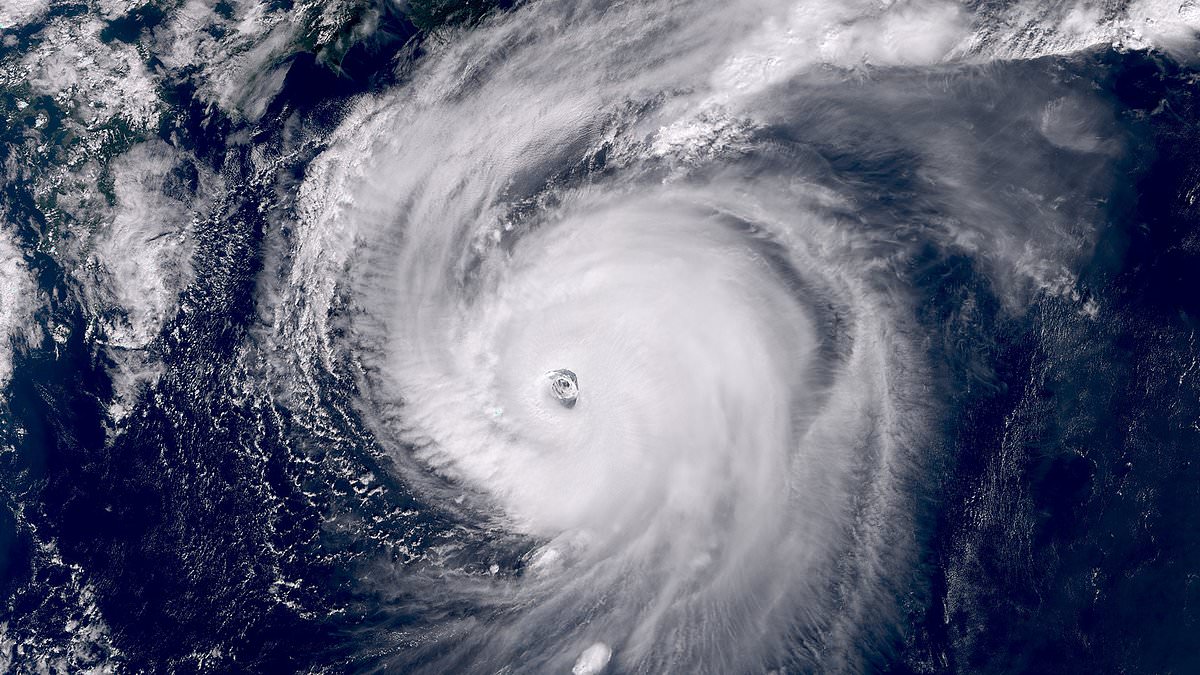
Typhoon Halong is swirling in the Pacific Ocean, just missing Japan. Meteorologists warn its remnants could help drive heavy rain and snow in California by early next week
Meteorologists emphasized that recurving typhoons degrade the precision of weather models, meaning forecasts will likely fluctuate over the next several days.
If the storm tracks closer to the coast, the Bay Area could see the heaviest rainfall since last winter, the San Francisco Chronicle reported.
Northern California is already experiencing early effects of a shifting weather pattern. Bay Area residents could wake on Thursday to drizzle and cooler temperatures under a deep marine layer.
A stalled low-pressure system off the Oregon coast may bring limited showers to the North Bay Friday and Saturday, though areas south of the Golden Gate are expected to remain mostly dry.
Showers will be more widespread in the northern reaches, including Ukiah, Eureka, and around Mount Shasta.
Sunday is expected to be drier, with clearing skies providing a calm backdrop for Fleet Week festivities in San Francisco.
The primary difference between a typhoon and a hurricane is the geographic location where the storm forms.
Both are the same type of weather phenomenon, a powerful tropical cyclone with winds of 74 mph or greater.
The energy from Halong is expected to move a high-pressure system into Canada , pushing subarctic air southward into Washington, Oregon and California by Monday
NASA’s International Space Station captured an eerie image of the typhoon from space this week
However, typhoons form in the Northwest Pacific Ocean, while hurricanes develop in the North Atlantic Ocean, the Northeast Pacific Ocean or the Central Pacific Ocean.
Warnings about the typhoon come as Hurricane Priscilla is moving north in the Pacific, putting southern California and Arizona in its ‘cone of uncertainty.’
The ‘inevitable’ US disasters that keep scientists up at night
The National Hurricane Center (NHC) uses a ‘cone of uncertainty’ to show the likely path of a hurricane like Priscilla on maps, with the cone widening to cover areas where the storm might go over the next three to five days.
The latest cone revealed that the Category 2 storm’s path is expected to shift north, turning Priscilla towards land on Thursday.
Spaghetti models revealed that Priscilla will likely barrel over Mexico and reach as far inland as Southern California and Arizona before it begins to break up.
Several other states in the Southwest, including New Mexico, Colorado, Utah, and Nevada, have been warned to expect thunderstorms and flash floods due to the moisture being pulled inland from Priscilla starting tomorrow and lasting through Sunday.
Parts of Arizona, New Mexico, Colorado, and Utah could see up to four inches of rain between Thursday afternoon and Saturday night.
AccuWeather lead hurricane expert Alex DaSilva noted that Priscilla’s impact on Arizona could be particularly severe on Thursday night, with heavy rain and flooding forecasted throughout the state.
The intense downpours could end up doubling the 1.5 inches of rainfall that places like Flagstaff, Arizona, typically get during an average October.
OregonArizona
Share or comment on this article:
Super typhoon’s shockwaves to unleash chaos on the US West Coast in just DAYS
Add comment