By Holly Chik,Victoria Bela
Copyright scmp
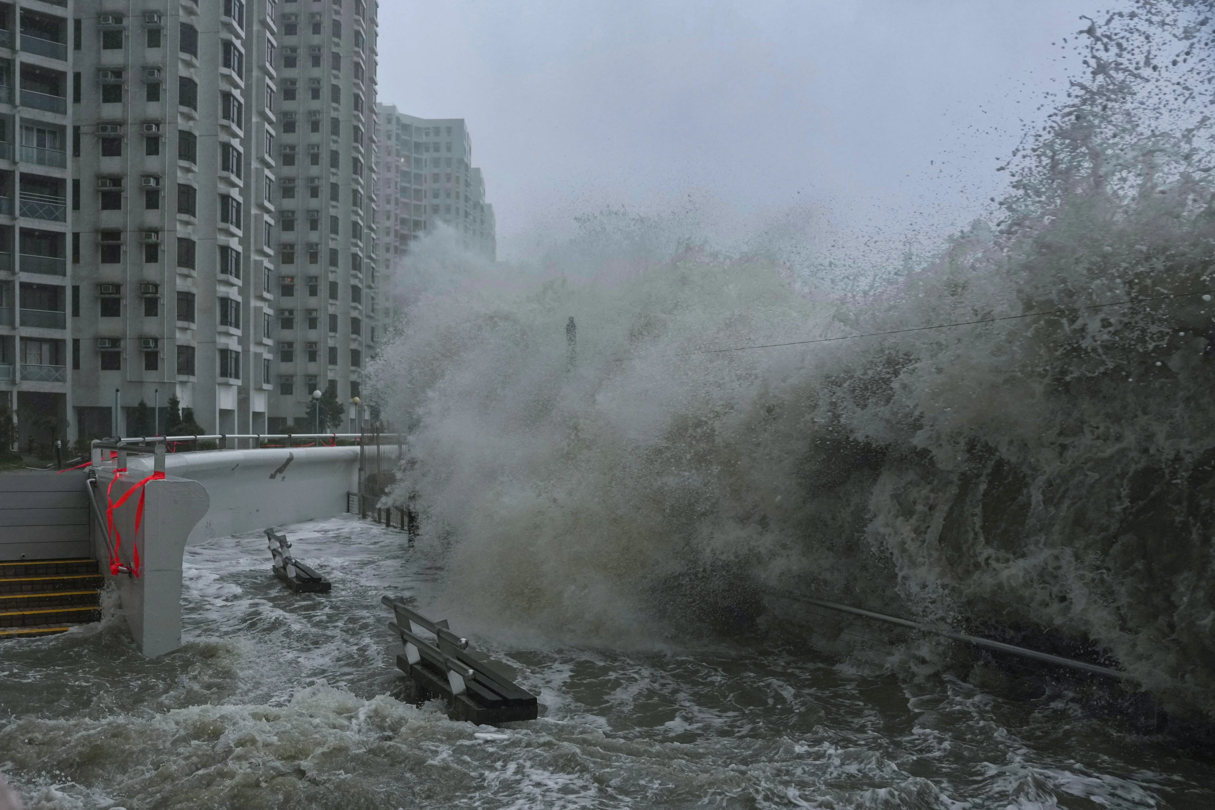
Super Typhoon Ragasa, which lashed Hong Kong and the southern Chinese province of Guangdong on Wednesday, has drawn warnings from scientists that climate change is making such storms more frequent.
Benjamin Horton, dean of the school of energy and environment at City University of Hong Kong, said: “Climate scientists know better than anyone else that these events should not be happening at such regularity, so late in the season, of such intensity, of such high winds and of such big storm surges. The attribution of why this event is occurring is climate change.”
He said super typhoons were becoming more common, adding: “There is just more energy. Climate change means that the intensification – how rapidly they go from a storm to a super typhoon – is quicker.
“With climate change [typhoons] are more likely to stall along the coast. Because they have got more energy, they do not move inland like previous typhoons would do, lose their strength and basically filter out. Nowadays, they can sit over the coastline and deliver colossal amounts of rain.”
Typhoons were increasing in size due to warmer ocean temperatures, a direct consequence of climate change, Horton said.
Average temperatures in the Pacific Ocean have risen by about 1.5 degrees Celsius in the past century, according to the United Nations Environment Programme.
“Typhoons exist on planet Earth to dissipate heat. The more heat in the ocean, the more tropical cyclones you get to remove the heat. The Earth is an amazing balance. It is obvious that if you warm up the oceans, these typhoons are going to be bigger,” Horton said.
“You have got a lot of warm water giving it a lot of energy. Its track is perfect for maximum destruction because it has not made landfall over any significant area to reduce its strength.”
The Hong Kong Observatory issued its highest level warning, a No 10 signal, for Ragasa, which saw wind speeds of over 200 km/h (120 mph). It was the second No 10 signal of the year – the first time this has happened since 1964.
Horton said previous records “provide context but they are not relevant to 2025 because those records were at time periods where we had lower temperatures, lower sea levels and lower carbon dioxide”.
“We are in a different era now. We crossed the 1.5 degrees Celsius threshold that every scientist said you should not cross because what happens is that our systems collapse,” he said, referring to the Paris Agreement goal of limiting global warming to no more than 1.5 degrees Celsius above pre-industrial levels. “This is an example of it.”
He also pointed to studies by former director of the Nasa Goddard Institute for Space Studies James Hansen, warning that when the Earth experienced similar climate conditions more than 100,000 years ago changes in ocean temperatures had created more “superstorms”.
Hansen, now the director of climate science, awareness and solutions at Columbia University, warned in a series of videos posted on YouTube in 2016 that melting ice sheets had placed a “freshwater lens” over the oceans, causing them to retain extra heat, which in turn led to further ice sheet melting.
This added water slowed and even shut down two key ocean currents, creating large global temperature differences that drove these superstorms.
“Such a situation occurred in the last interglacial period, 118,000 years ago. The tropics were about one degree warmer than today because Earth’s spin axis was tilted less than today,” Hansen said.
“Ocean core data show that deep water formation shut down, the North Atlantic cooled, and there is evidence of powerful superstorms at about that time.”
On Monday the Japanese astronaut Kimiya Yui posted pictures of the typhoon taken from the International Space Station, saying: “I am really worried about everyone on the ground.”
Michael Ferragamo, a tropical cyclone researcher at the University of Oklahoma, posted on social media that Ragasa had been strengthened by a phenomenon known as “eyewall replacement”.
The eyewall is the most dangerous part of a hurricane or typhoon and when this intensified it transformed Ragasa into a super typhoon.
Its strength was equivalent to a Category 5 hurricane – the current highest level for Atlantic hurricanes, which can see wind speeds of more than 250km/h (155mph).
A study published in the Proceedings of the National Academy of Sciences last year stated that as global warming leads to more intense tropical cyclones, this wind scale may need to be expanded.
“We find that a number of recent storms have already achieved this hypothetical category 6 intensity,” researchers from Lawrence Berkeley National Laboratory and the University of Wisconsin-Madison wrote.
“Based on multiple independent lines of evidence examining the highest simulated and potential peak wind speeds, more such storms are projected as the climate continues to warm”.
Some observers, such as the storm-tracking blog Backpirch Weather, have said the intensity of Typhoon Ragasa appeared to be reaching the upper limits of what was possible for a tropical cyclone.
The intensity of these storms is limited by a combination of factors, including oceanic heat, atmospheric conditions, and the storm’s energy conversion.
Typhoon Ragasa benefited from high sea surface temperatures of around 30 degrees Celsius (86 degrees Fahrenheit), a symmetrical storm structure, and low wind shear – changes to wind speed or direction that can disrupt the storm’s structure and cut off its energy supply – according to Canada’s The Weather Network.