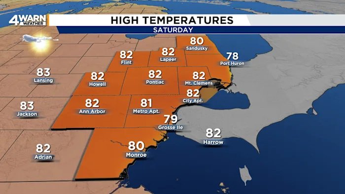
4Warn Weather – SATURDAY: Mostly sunny skies. Continued warm. High: 81.
SATURDAY NIGHT: Mainly clear skies, patchy dense fog possible. Low: 57.
SUNDAY: Mostly sunny skies. High: 81.
SUNDAY NIGHT: Mainly clear skies. Low: 55.
MONDAY: Mostly sunny skies. High: 80.
After lots of sunshine and warm temperatures to end the week, we are going to keep the trend of dry weather into the forecast, looking through the weekend and then at the start of next week as well.
High pressure has been controlling the forecast for the majority of the week, and it will move off to the east throughout Saturday. We will watch a warm front lift north of the region Saturday afternoon to Saturday evening, bringing a strong southerly flow into the region as well. This will send her a high temperature soaring into the 80s once again by Saturday afternoon.
That warm front will be followed by a cold front late Saturday night, early on Sunday morning, but there is barely any cloud cover and no rain forecast with this front to move through by the time we get to early Sunday morning. Behind that front, there won’t be much of a dip in temperatures either. We are expecting plenty of sunshine for the end of the weekend on Sunday, and temperatures is back into the 80s by the time we get to Sunday afternoon.
High pressure builds back in for the start of next week on Monday, which keeps the sunshine into the forecast along with well-above-average temperatures. We’re back into the 80s once again by the time we get to late Monday afternoon.
Another cold front rolls into the region by Tuesday, and this does bring a little more cloud cover for the middle of the week. But once again, we are not forecasting any rain with the frontal boundary that will move through Tuesday into Tuesday night. Temperatures start to drop by the time we get to the middle of next week, we’re under into the upper 70s by Tuesday afternoon.
Once that front moves through by late Tuesday night, we will bring more sunshine into the forecast for the second half of next week, but we will also bring some cooler air in behind that front as well. Expect temperatures to drop into the low to mid-70s by the time we get to Thursday and Friday. And expect that dry weather to continue into the start of next week and on Saturday as well. Temperatures will remain in the low to mid 70s by the time we get to next Saturday afternoon.
TROPICAL UPDATE: We’re tracking two systems in the Western Atlantic to start the weekend:
HURRICANE HUMBERTO: Well out into the Atlantic, a Category 4 Hurricane as of Saturday Morning. Current forecasts keep Humberto well out into the Atlantic as a hurricane for at least the next two to three days.
POTENTIAL TROPICAL CYCLONE NINE (SOON TO BE IMELDA): Potential Tropical Cyclone Nine has formed near the southeastern Bahamas, and forecasters expect it to strengthen into Tropical Storm Imelda within the next day. Right now, the system is producing heavy rain, gusty winds, and rough seas across parts of the Bahamas and eastern Cuba. The environment ahead — warm ocean water and decreasing wind shear — is favorable for further development.
Looking ahead, most forecasts bring the storm northward toward the Southeast U.S. coast by early to mid next week. The Carolinas and southern Georgia are the areas to watch most closely, although the exact track is still uncertain. Even if the storm does not make a direct landfall, it could bring periods of heavy rain, strong winds, coastal flooding, and dangerous surf conditions.
Rainfall is expected to be one of the biggest hazards. Parts of the Bahamas and eastern Cuba could see more than half a foot of rain, with flooding and mudslide risks in mountainous areas. If the system moves near or over the Southeast coast, widespread rainfall totals of 4 to 8 inches are possible, with isolated higher amounts. That could lead to flooding, especially in low-lying or urban areas.
For now, people along the Georgia and Carolina coasts should stay alert and check daily updates from the National Hurricane Center. Don’t focus too much on the exact forecast track — impacts often extend well outside the “cone.” It’s a good idea to review your storm plans, secure outdoor items, and prepare for the possibility of power outages or travel disruptions next week.