Copyright CBS News
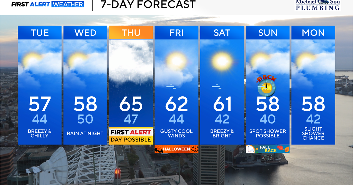
Mostly cloudy to cloudy skies along with a chilly northeasterly wind will give Tuesday and Wednesday a chilly feel across central and eastern Maryland. High temperatures will only reach the upper 50s. While there could be a few sprinkles later Tuesday across the eastern shore, the bulk of our next rain event will arrive Wednesday night into Thursday. Maryland weather Tuesday and Wednesday Mostly cloudy to cloudy skies will blanket most of central and eastern Maryland through Wednesday. A storm system passing underneath will carry a batch of rain, mainly to our south. A few pockets of sprinkles or light drizzle is possible across the eastern shore later today into this evening, but the bulk of our area remains dry. Temperatures Tuesday afternoon will stay in the upper 50s with the additional clouds and persistent northeast winds at 10 to 20 mph. Wednesday will feature a good deal of cloud cover with another approaching area of low pressure arriving later in the day or at night. This will spread scattered showers or a period of steadier rain into the area Wednesday night. Rainfall amounts should remain on the light side Wednesday night through the predawn Thursday. Stormy weather across Maryland Thursday morning Rain, heavy at times, along with gusty winds and possible thunderstorms are becoming increasingly likely Thursday morning. Latest computer model guidance suggests 1 to 3" of rain across the area, with many models suggesting 2 to 3 inches in and around the Baltimore metro. This will cause localized flooding during the morning commute along with travel delays. Winds gusting 25 to 35 mph will cause localized power outages with snapped tree branches falling on powerlines. The heaviest rain should exit before 3 p.m. The WJZ First Alert Weather Team will likely upgrade Thursday to a First Alert Weather Day for a tough morning commute with the stormy weather. 🎃 Trick-or-treat weather for Baltimore area Halloween looks mostly dry across the city and suburbs but chilly and breezy — perfect for spooky vibes, not so much for thin costumes. Highs during the day only reach the low to mid-50s with northwest gusts pushing 25–35 mph. After sunset, when trick-or-treating ramps up, temps slide into the upper 40s to near 50° with a lighter breeze. Anyone out late for parties or bar crawls will feel temps dip to the low-to-mid 40s. Costumes with layers underneath will be key. Weekend weather across Maryland Saturday looks calmer and brighter, with highs in the low-to-mid 50s and continued cool air settling over all of Maryland. By Sunday, clouds increase again and a chance for showers returns later in the afternoon or evening, with temps still stuck in the 50s for most neighborhoods around Baltimore.