This story appears as part of a collaboration to strengthen investigative journalism in Maine between the BDN and The Maine Monitor. Read more about the partnership.
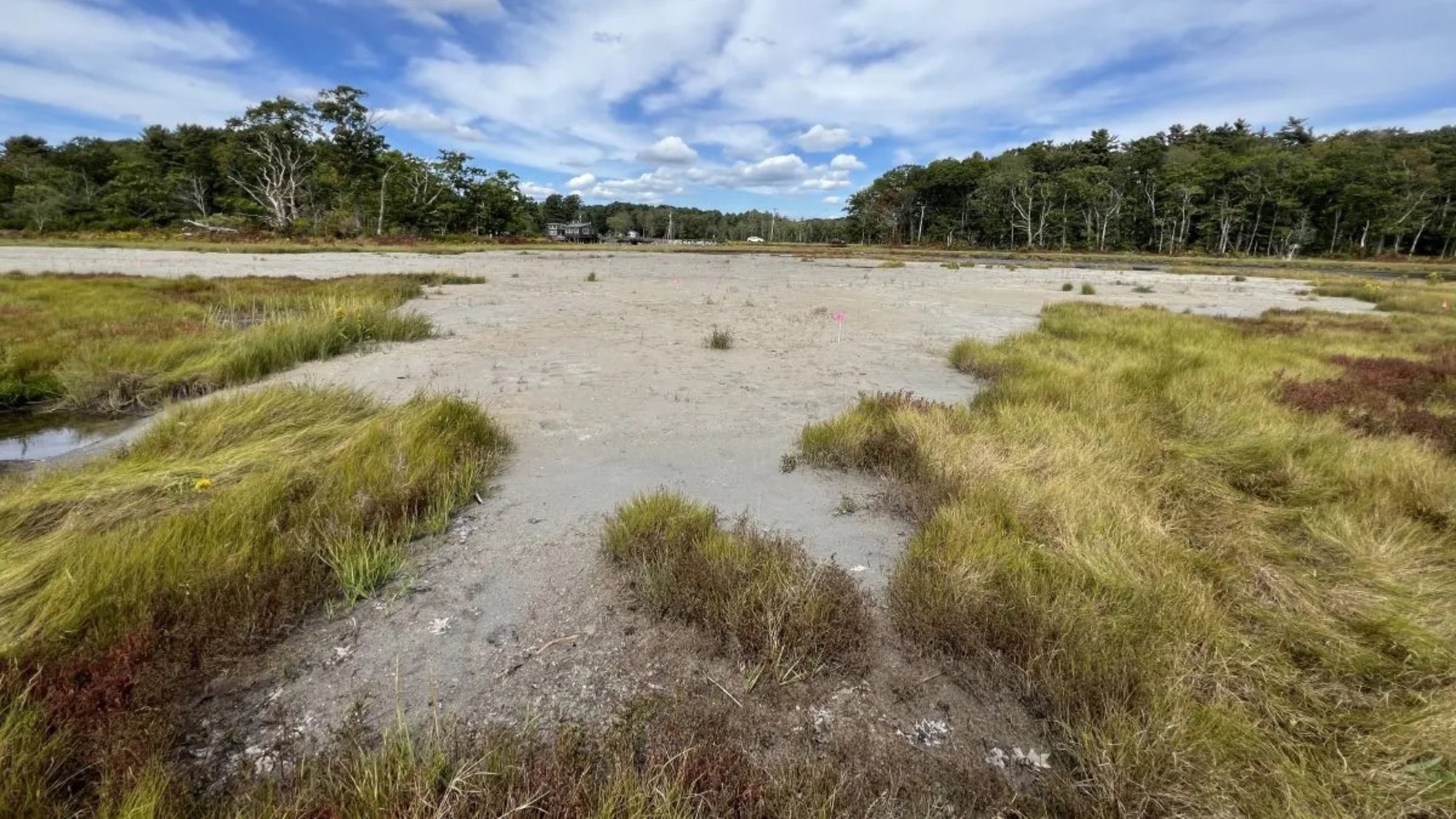
On a humid August morning, the Webhannet salt marsh in Wells was a sea of tousled, neon-green grass. But at the marsh’s northern edge, one spot stood out — about two acres of glittering white sand with only a few plants breaking through. Late last winter, excavators spread sand dredged from the nearby harbor there, in a bid to save the sinking marsh and protect the birds that rely on it.
The marsh is a test site for a type of restoration never before tried in Maine, known as the “beneficial use of dredged materials.” The method involves spreading a thin layer of sand and sediment to raise the marsh surface, helping it better withstand sea level rise and support birds like the endangered saltmarsh sparrow and black ducks. At this site, crews used 1,000 cubic yards of sand to raise the elevation by 3 to 6 inches.
At this time last year, this part of the marsh was much wetter. It flooded often and a large deep pool was expanding every year.
“When it’s completely waterlogged all the time the peat starts to break apart,” said Bri Benvenuti, a regional biologist at Ducks Unlimited, which led the project in cooperation with a group of local and federal agencies and university researchers. “It gets really soggy and mucky and decomposes, essentially.”
The Webhannet marsh, like many others in Maine and along the East Coast, is drowning as sea levels rise. Marshes act like sponges, absorbing flood waters and storm surges, and buffering communities from storm damage, while providing habitat to many species.
One of the reasons marshes are struggling to keep pace with climate change is because they are starved of sediment-like sand and mud. In an unaltered system, storms would wash up over barrier beaches and dunes, bringing sand onto the marsh.
This constant accumulation of sediment counteracts erosion, helping the marsh remain stable — which is even more critical as sea levels rise. But development — like roads, culverts and the strip of beachfront homes on Drakes Island beach has disrupted the process.
“Those dunes are largely non-existent now because they’re houses,” Benvenuti explained. “So the sand isn’t moving over those dunes at all.”
To mimic these processes, some scientists and conservationists in some parts of the country, particularly the Gulf Coast, have turned to the sand and sediment dredged from harbors and channels.
While much of the material is dumped offshore or spread on beaches, it could be put to better use, Benvenuti said. “If we have this sediment that’s going to be pumped onto a beach or disposed of offshore, why can’t we put it onto a marsh instead?”
The idea isn’t quite as simple as it sounds. Getting the necessary permits took years, since this was the first project of its type in Maine. After dredging, the sand had to be tested for contaminants, and screened to remove debris.
University of New Hampshire researchers and Ducks Unlimited measured the site’s topography using LIDAR to determine how much sand to spread in different areas. To improve drainage to the site, a berm was removed and small channels were dug. And, in order to protect the marsh from damage, the crews had to wait until the ground was frozen and, even then, used special mats to move across the surface.
If the Wells pilot project is successful, Benvenuti hopes to see the technique used in other parts of the state and region.
The project, which cost about a million dollars, is a collaboration between the town of Wells, Ducks Unlimited, the University of New Hampshire and state and federal agencies, and was funded by Greenfield Penobscot Estuary Beneficial Project Trust and two private foundations. Researchers from the University of New Hampshire are monitoring a host of factors including marsh elevation, hydrology, soil biogeochemistry, tidal bird abundance and salt marsh sparrow nesting.
Salt marsh sparrows are small, orange-cheeked birds with a call that sounds like radio static. They are salt marsh obligates, which means they can’t live anywhere else. They are so adapted to the rhythms of the tides that the bird’s entire reproductive cycle from nesting to fledging takes place between the highest tides of the month, when the marsh’s water levels are highest. The bird is an indicator species for salt marshes — a proxy for how well the marshes are faring overall.
And the indications aren’t good, said Adrienne Kovach, a professor in the University of New Hampshire’s department of natural resources and the environment, standing at the restoration site in the Wells marsh where researchers have been monitoring populations for years.
As sea levels rise, fewer young are surviving because their nests are flooded before the birds can fledge. The bird’s population has fallen by 90% over the last two decades. If nothing changes, salt marsh sparrows are projected to go extinct by 2050.
In a portion of the marsh that includes the pilot project, researchers found nine nests this year. But six of the nests failed — the eggs in one were eaten by predators, but the others were taken by the rising water — either the eggs floated out of the nest or the hatchlings drowned.
Looking out across the expanse of sparkling white sand, Kovach said things were looking promising so far. She pointed out withered stalks of Glasswort, a plant adapted to the wettest parts of the marsh. In the sandy zone, it was dry and dead. But outside the sandy spot, it was healthy.
This suggests that the spot where the sediment was spread was already dryer than surrounding areas. Project organizers hope that, within five years, the site will be fully revegetated with the species of grass that salt marsh sparrows use to nest and will flood only twice a month during the highest tides.
Pointing out a few blades of marsh grass poking through the crusty sand Kovach said, “Hopefully in a year or few, it’ll look really different.”