Copyright euroweeklynews
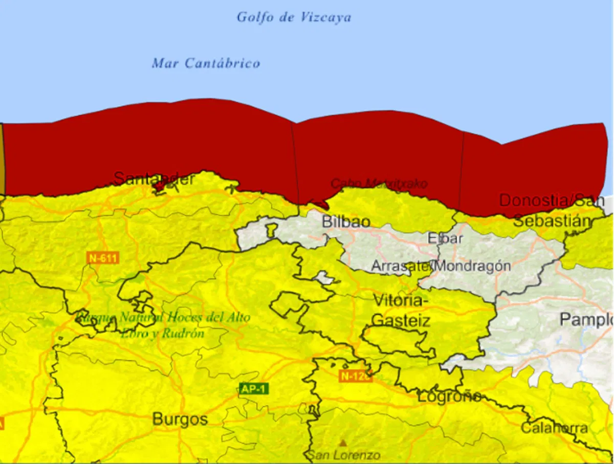
Heavy rain, strong winds and a sudden drop in temperatures are sweeping across northern Spain this Thursday, October 23, as Storm Benjamín makes landfall. The weather front, officially named by the French meteorological service, is the second major storm of the season, and Spain’s national weather agency AEMET has already issued several orange and red alerts across the country. The storm began showing its force on Wednesday evening, hitting A Coruña and Lugo in Galicia with strong gusts and heavy rain, prompting orange warnings from AEMET. But conditions are set to worsen today, especially along the Cantabrian coast, where red warnings are now in place for Vizcaya and Gipuzkoa due to waves of up to seven metres and powerful winds. Storm Benjamín spreads across northern Spain According to AEMET, Benjamín is bringing widespread instability across much of the peninsula, particularly in the north and northwest. Gale-force winds, maritime storms, and persistent rain will continue throughout Thursday, with coastal areas of Galicia and the Bay of Biscay expected to see the most intense conditions. The agency has also warned that the effects of the storm won’t be limited to the north. The Balearic Islands and other parts of the peninsula will begin to feel the impact of the system by Thursday night, as strong winds and cloud cover move eastward. For residents in the Cantabrian region and the Pyrenees, heavy rainfall is likely to continue through Friday, with possible flooding in some low-lying areas. AEMET has urged caution, especially for those planning travel or outdoor activities in the most affected zones. Sharp contrast in temperatures between north and south While the north braces for the full force of the storm, the south of Spain is living a completely different story. Temperatures there remain unseasonably high, with some parts of Andalusia still expected to reach above 30°C. From Friday October 24, however, the cold front will begin to push further inland, bringing a noticeable drop in temperatures across central and northern Spain. Rain will continue, particularly in Galicia, the Cantabrian region and the Central System, reinforcing the dramatic north-south contrast that often marks Spain’s autumn weather. Unsettled weekend ahead The unstable weather isn’t expected to end with the workweek. AEMET predicts more fronts arriving over the weekend, with a potential low-pressure system forming over the Mediterranean. This could bring cloudy skies and rain to large parts of the country, especially in the northwest and central regions. According to early forecasts, Saturday could bring persistent rainfall in Galicia, Castilla y León and the Central System, as cooler air settles over much of Spain. Coastal areas, meanwhile, will continue facing rough seas and strong winds, particularly in the north. As the country adjusts to the first serious bout of autumn weather, authorities are urging residents and visitors alike to stay informed through AEMET’s official alerts and to take extra care when travelling or spending time outdoors. For now, Storm Benjamín marks a sharp reminder that Spain’s mild autumn days may soon be behind us – and that the season of Atlantic storms has truly begun. Stay tuned with Euro Weekly News for more news from Spain