Copyright Santa Rosa Press Democrat
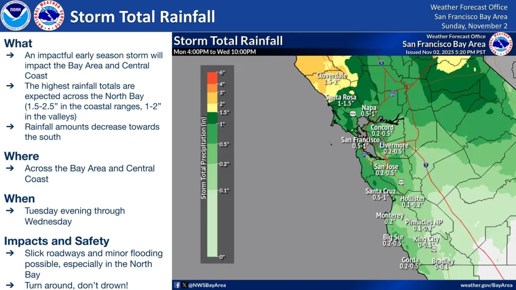
An early-season storm is expected to sweep through the North Bay this week, bringing heavy rain, strong winds and the potential for minor flooding, according to the National Weather Service. Forecasters predict up to 2.5 inches of rain and wind gusts as strong as 55 mph between late Tuesday night and Wednesday afternoon. Valleys could see 1 to 2 inches of rain, with higher totals — up to 2.5 inches — likely in the coastal mountains of northwest Sonoma County. Cloverdale could receive up to 2 inches, Santa Rosa around 1.5 and Napa between a half-inch and an inch. Meteorologist Ryan Walbrun described the incoming system as a “relatively strong,” winter-like storm that will primarily benefit the region by replenishing reservoirs and lowering wildfire risk. The North Bay will take the brunt of the storm, he said, and Wednesday morning commutes will likely be affected. “People are going to notice it,” Walburn said. “It is going to alter their day a little bit.” A wind advisory will be in effect from 10 p.m. Tuesday through 4 p.m. Wednesday across Sonoma and Napa counties, with southerly gusts between 35 and 45 mph and isolated gusts up to 55 mph possible along ridgelines and the coast. Wet and gusty conditions are expected to slow commutes and could cause scattered power outages if tree limbs fall or power poles sway in the wind. While the storm is expected to be mostly beneficial, forecasters warn that minor flooding could occur in low-lying or poorly drained areas. Main rivers such as the Russian and Napa are not expected to flood. There’s also a 10% to 20% chance of thunderstorms, particularly between 4 a.m. and 10 a.m. Wednesday as the main front moves through. After the rain, large waves from the northwest will reach the coast, creating dangerous beach conditions through the weekend. Forecasters warn of sneaker waves and rip currents, with breakers up to 12 to 15 feet high. A coastal flood advisory will remain in effect from 8 a.m. Tuesday through 2 p.m. Saturday as higher-than-normal tides could push seawater about a foot above normal in low-lying coastal areas. With multiple weather hazards expected, Walbrun advised residents to secure loose outdoor items, clear gutters and allow extra time for travel.