Copyright foxweather
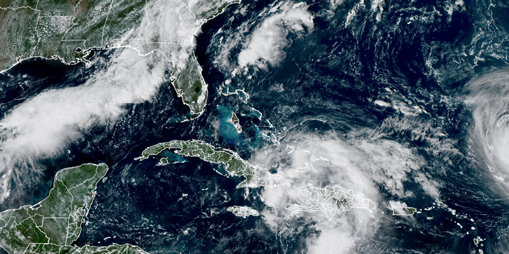
MIAMI – What was Invest 94L in the Atlantic Ocean was designated Potential Tropical Cyclone Nine on Friday, allowing officials to begin issuing alerts. Potential tropical cyclone is a status used by the National Hurricane Center when a tropical cyclone will likely impact the U.S. and warrants alerts but is short of being a named storm. Tropical Storm Warnings have been issued for the central Bahamas, while Tropical Storm Watches cover the northwestern Bahamas. PTC Nine is located in the vicinity of eastern Cuba and the southeastern Bahamas and has winds of 35 mph. Potential Tropical Cyclone Nine.(FOX Weather) BEWARE OF THE 'I' STORM: IT HAS MORE RETIREES THAN ANY LETTER USED FOR ATLANTIC HURRICANE NAMES It is forecast to become a tropical depression on Saturday, and then Tropical Storm Imelda on Saturday night or early Sunday, according to the NHC. There is tremendous uncertainty in the forecast track at this time due to multiple factors, one of which is the proximity of strengthening Hurricane Humberto. Current Tropical Alerts.(FOX Weather) BRYAN NORCROSS: LATEST COMPUTER FORECASTS SHOW INCREASED THREAT TO FLORIDA, SOUTHEAST FROM LIKELY-IMELDA FOX Weather Hurricane Specialist Bryan Norcross agreed, noting that computer models are split on whether likely-Imelda will directly hit the U.S. mainland. Potential Tropical Cyclone Nine Forecast Cone.(FOX Weather) "There is a strong consensus in the various computer forecasts that Imelda will likely track to the north, paralleling the Florida coast at least through the weekend," Norcross said Friday. "About Monday, however, it looks likely to face a fork in the road. Either it will turn right, out to sea, or it will arc left into the Georgia, South Carolina, or North Carolina coast." Norcross emphasized that forecasts for just-developing systems are subject to large errors and are likely to change. NOAA's Hurricane Hunters flew reconnaissance missions into Invest 94L Thursday and Friday which will provide the NHC with better data collection in both the upper and lower levels of the atmosphere. This data will help computer forecast models develop a more accurate picture of the track and future intensity of the storm. ATLANTIC HURRICANE SEASON ABOUT TO PULL OFF FEAT NOT SEEN IN 90 YEARS States prepare for potential impacts South Carolina Gov. Henry McMaster said Wednesday that the state's emergency management division is working with the National Weather Service to monitor developments. The City of Charleston announced Friday that stormwater pumps had been deployed, and local lake levels had been lowered, among other preparations. Conway, South Carolina declared a local State of Emergency ahead of the storm and Folly Beach closed its City Hall on Friday. North Carolina's Emergency Management department said it is also monitoring the latest weather forecasts. HOW TO WATCH FOX WEATHER Duke Energy, which services power to 80 counties in North Carolina, says a significant portion of the storm's possible paths are in their service area. "Our in house team of meteorologists is following the path of that storm, and we use that forecast to power our damage modeling system," spokesperson Jeff Brooks told FOX Weather. "And that modeling system helps us to identify where we’re likely to see storm impacts. Our goal is always if we can is to position resources at the appropriate places so they’re able to respond quickly when the storm strikes." Torrential rains threaten dangerous flooding in Caribbean PTC 9 is expected to bring several inches of rain to the Bahamas and nearby Caribbean Islands, prompting flash flooding threats. Eastern Cuba is expected to get the worst of the rain, with about 8-12 inches in general, and some spots receiving up to 16 inches. About 4–8 inches are expected in the Bahamas, and 2-4 inches in Jamaica and Hispaniola. "This rainfall will likely produce flash and urban flooding. Mudslides are also possible in areas of higher terrain across eastern Cuba, Hispaniola, and Jamaica," the NHC said. In addition, tropical storm-force winds are likely in the warned area of the Bahamas starting Saturday night, and possible on Sunday in the northern Bahamas, the NHC said.