A storm system known as a nor’easter is expected to sweep along the U.S. coastline later this week, bringing with it the threat of heavy rain and coastal flooding to eastern parts of the country.
Why It Matters
A nor’easter is a coastal storm affecting the Eastern Seaboard of North America, named for the prevailing northeast winds it brings to shore, according to the National Weather Service (NWS).
These storms can happen year-round, but they’re most common and intense from September through April, the agency says.
As of reporting, the NWS has issued flood watches, warnings and advisories along the East Coast from Florida to New England.
What To Know
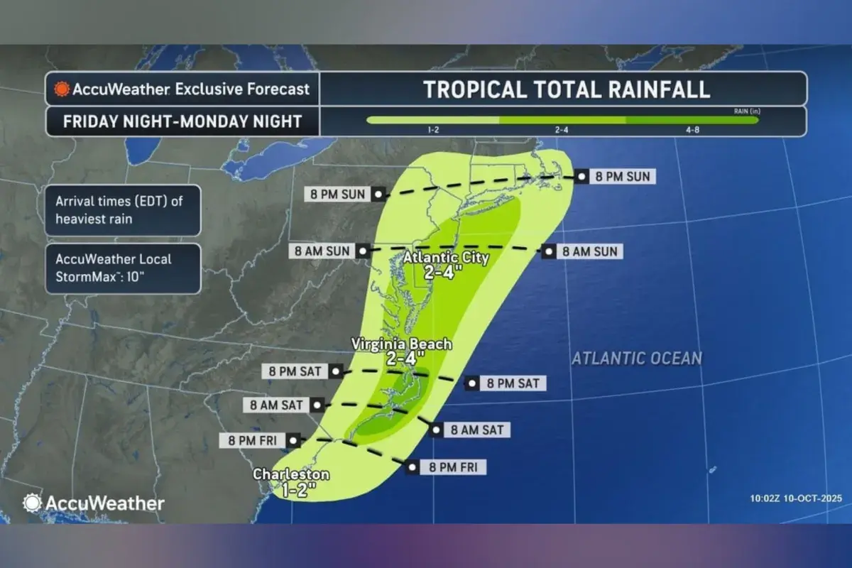
Wind gusts between 40 and 60 mph could bring down trees and power lines from southeastern Virginia to southern New England, while rainfall totals of 4 to 8 inches may lead to urban flooding, said an advisory from AccuWeather shared with Newsweek.
Tides are expected to rise 1 to 3 feet above normal levels from North Carolina to Cape Cod, according to AccuWeather, with coastal flooding likely on barrier islands, in ports and in low-lying business districts—as elevated seas continue for several days.
Offshore waves reaching 10 to 20 feet, along with prolonged high surf, could lead to substantial beach erosion and dune damage, according to the outlet.
AccuWeather meteorologist Dan Pydynowski told Newsweek that there could be be gusty winds, rough surf, coastal flooding and beach erosion this weekend into Monday—primarily along North Carolina’s Outer Banks northward into southern New England.
“Sporadic power outages could occur from the gusty winds as well,” Pydynowski said.
What People Are Saying
Roger Martin, a meteorologist with NWS Newport/Morehead City, North Carolina, told Newsweek: “There is a strong weather system moving through the Southeast U.S. that will trigger the development of a coastal low by early Saturday morning east of Florida/Georgia. This low is then forecast to move north along the U.S. East Coast this weekend and early next week.
“This storm system is expected to produce multiple hazards up and down the coast, including coastal flooding, dangerous rip currents, beach erosion, strong to potentially damaging wind gusts, and heavy rain and flooding. The impacts will vary from one location to another, and not all coastal locations will experience the same level of impact.”
Meteorologist Noah Bergren wrote on X on Wednesday: “The center of this powerful Nor’easter will likely come ‘ashore’ somewhere on the New Jersey shoreline Sunday with 40-70 MPH gusts right on the beaches and areas of coastal flooding and surge at times of high tide. Heavy rain should extend past the Mass Pike into Southern New England.”
What Happens Next
Regional NWS branches issue regular local forecast updates on the agency’s website and social media channels.