NEW FRANKLIN — The state Route 619 corridor in New Franklin will look much different in the next decade, according to a state Route 619 Corridor Study presentation by OHM Advisors at the Oct. 1 City Council meeting.
OHM Project Engineer Josh Slaga said the roughly six-month city-commissioned study breaks the corridor into three segments, from State Street to the Green border, and focuses on creating a more connected corridor, the needs of residents and potential growth and development.
“This is a vision, but it is going to take many years to become a reality,” Slaga said. He added a conservative estimate would have all three of the phases completed in the next 15 years, but noted “it could go quicker” depending largely on funding.
OHM Planner Erica Tinnirello said with the corridor seeing 10,000 vehicles per day, and rear-end crashes not uncommon, a large part of the study focuses on traffic safety and congestion, speeding, and pedestrian and bicycle access through sidewalks and multi-use trails in the “key intersections” of South Turkeyfoot Road, Old State Park Drive and Boston Avenue.
Slaga said the westernmost section of the corridor, at State Street, is the least dense area and is called the “transitional zone” in the study, with only sidewalks and a multi-use trail recommended.
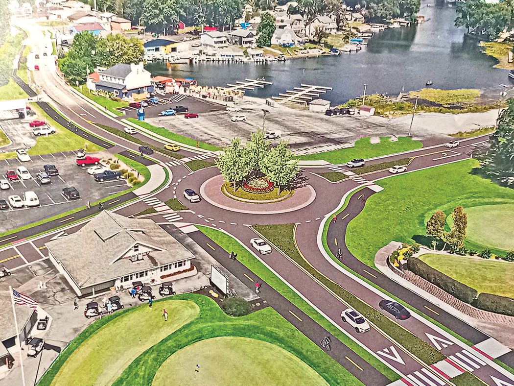
Moving eastward, the “central zone” would add more landscaping, lighting, space for public parking lots and a “compact” roundabout at Boston Avenue. Slaga called this segment of the corridor its “dense commercial core.”
The third segment, known as the “gateway zone,” is located at South Turkeyfoot Road and would include a single lane roundabout, controlled pedestrian crossing and a pedestrian bridge over the West Reservoir channel. Slaga added a planned pedestrian crossing east of the roundabout would create a safer crossing for golf carts from Turkeyfoot Lake Golf Links, since both vehicle and golf cart drivers would have better traffic visibility than at the current crossing at South Turkeyfoot.
“All of these phases would cost around $10 million, so this project fits with a phasing [approach],” he said.
Tinnirello said starting in the gateway district would be the most beneficial and impactful, creating a more walkable destination and potential future entertainment area. She said this first phase has an estimated $5 million price tag, with various state and funding sources available — including the Akron Metropolitan Traffic Study (AMATS) Ohio Public Works Commission and the Ohio Department of Transportation (ODOT) — as well as potential commercial developer investments in the future.
Mayor Paul Adamson said the city is also continuing to lobby these sources for sewer and water connection in the corridor.
City council members gave unanimous verbal approval of the study, with legislation to apply for an AMATS Surface Transportation Grant to be presented at the next Council meeting Oct. 15. Slaga said if the city is successful in securing this funding, it would pay for “80 to 90% of [phase one] construction costs,” with the city responsible for the remainder, as well as engineering costs.
Slaga added the project would not begin until at least 2030, giving the city roughly five years to source its portion of the project costs.
Also at the meeting, Council approved:
• the creation of a fund for the Grill Road Bridge Project and authorizing appropriations of $563,789 into the fund. Finance Director Susan Cooke said this is pass-through money for an ODOT project the city is required to “show on our books”; and
• a $95,026 contract with CTL Engineering for the Grill Road Bridge Project, with federal funding through the National Transportation Act paying 95% of the costs and the city responsible for the remaining $4,751.
New Franklin City Council next meets Oct. 15 at 6 p.m. at City Hall, 5611 Manchester Road. The meeting is also available for viewing on the city’s Facebook page.