Copyright NJ.com
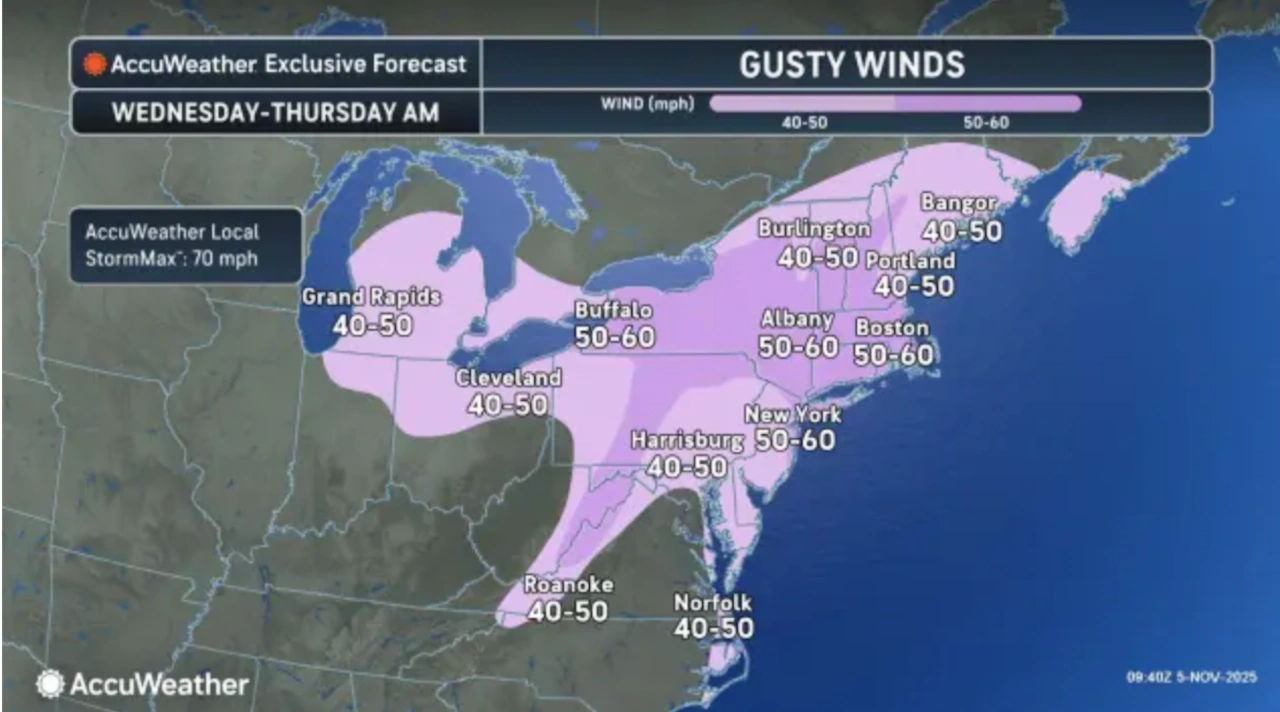
A strong cold front will bring potentially damaging winds to New Jersey tonight, with gusts of 50 to 60 mph possible across the state. High wind watches and wind advisories have been issued for the entire state. “Strong winds will arrive behind a cold front late today and tonight,” the National Weather Service said early Wednesday. “The start of winds may be accompanied by a line of showers with gusts up to 60 mph. Damage to trees and utilities possible. Blow-out tides (very low water levels) possible tonight and Thursday on tidal waters.” The approaching system will bring increasing southwest winds throughout Wednesday, reaching 25 to 35 mph this afternoon, particularly along the Jersey Shore. The strongest winds will occur for a 3 to 6-hour period following the cold frontal passage, from around midnight to daybreak Thursday. The strong gusts could cause power outages and travel disruptions, the weather service said. The high wind watches will be in effect tonight for Atlantic, Cape May, Hudson, Monmouth, Ocean and eastern Bergen, eastern Essex, eastern Union and southeastern Burlington counties. Up to 60 mph gusts are possible in those areas. The rest of the state is under less severe wind advisories, though up to 50 mph gusts are possible in those counties. An isolated thunderstorm is possible as the front moves through, though the main concern remains the strong winds. The National Weather Service advises securing loose outdoor objects and being prepared for potential power outages. Temperatures today will be 3 to 5 degrees above normal before dropping behind the front. Thursday will see gradually diminishing winds as high pressure builds in from the west. Temperatures will drop to several degrees below normal with highs in the 50s. Thursday night will bring widespread frost as clear skies allow for strong radiational cooling, with freeze or frost alerts possible for locations where the growing season continues. Friday will see another fast-moving system approaching, bringing gusty southwest winds and temperatures climbing back above normal. Showers will likely accompany a cold front Friday night, with an isolated thunderstorm possible. Highs will reach the upper 50s to 60s. The weekend starts with any leftover rain ending by midday Saturday as the cold front pushes east of the area. Dry conditions are expected Saturday afternoon through Saturday night with temperatures in the upper 50s and 60s on both Saturday and Sunday. Another significant weather system will move through the region Sunday afternoon through early Sunday night, bringing another cold front that will cause a substantial temperature drop for the start of next week. Some rain and possibly snow will be possible Monday night into Tuesday, though no snow accumulations are expected at this time. High temperatures Monday through Wednesday will be much cooler, only reaching the 40s with some lower 50s near the coast possible on Wednesday. Monday night will be the coldest, with temperatures dropping into the 20s and lower 30s. Current weather radar