Copyright deccanchronicle
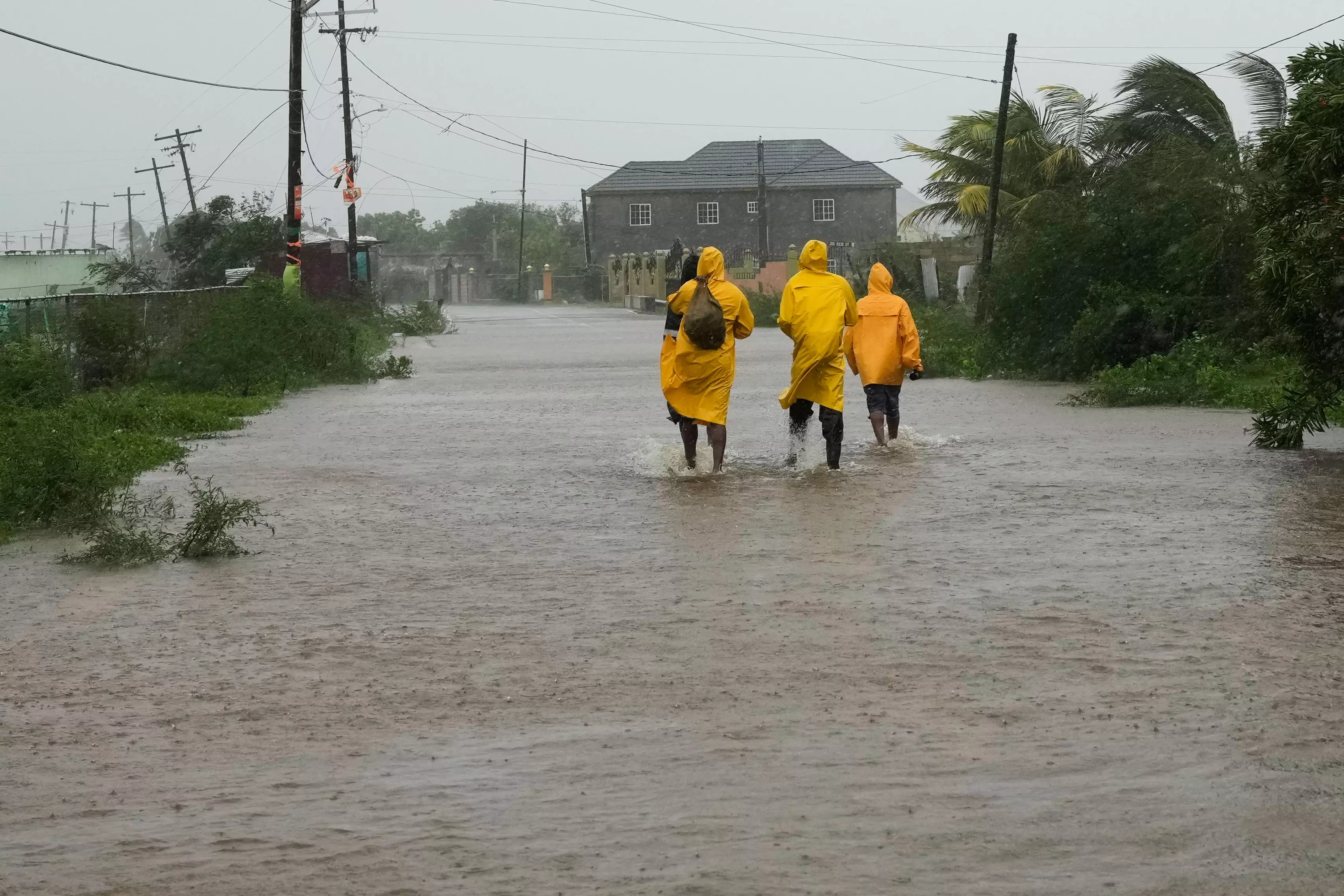
Churning through the Caribbean, Hurricane Melissa has made history this Tuesday, developing into a Category 5 cyclone with sustained winds of up to 185 mph (295 kph). As it raged towards Jamaica, locals were asked to evacuate and move to high ground and once the storm hit, thousands of locals were left without electricity and the country’s infrastructure incurred significant damage.While hurricanes are nothing new for Jamaica, never before has it experienced a Category 5 or even Category 4 storm firsthand. The government had even reached out to foreign aid in its preparation for Hurricane Melissa’s arrival.It’s terrifying to imagine the horrors locals have endured and will continue to endure in face of the cyclone. However, it appears that Hurricane Melissa just may be the tip of the iceberg. With global warming, scientists predict that rapid intensification and stalling storms are on the rise.Growing potential for rising wind speedsIt only took Melissa 24 hours to jump from a storm with a wind speed of 70 mph (110 kph) to 140 mph (225 kph), turning into a Category 4 storm. Now, it has strengthened into Category 5 i.e., the highest level on the Saffir-Simpson scale, making it the fourth of five Atlantic hurricanes to have dramatically intensified this season.“We haven’t had that many hurricanes in the Atlantic this season, but an unusual proportion of them went through a phase of intensifying quite rapidly,” meteorologist and climate scientist Kerry Emanuel of Massachusetts Institute of Technology revealed to AFP. “This may very well be collectively a signature of climate change.”Warmer sea surface temperatures fuel storms, and the difference in temperature between the water and the atmosphere further strengthens a hurricane’s destructive potential.Atmospheric scientist Daniel Gilford of nonprofit Climate Change told AFP, “There’s this atmospheric warming that tends to reduce the intensity, and there’s sea surface temperature warming, which tends to increase the intensity.”The sea surface temperature usually prevails.Hurricane Melissa passed over waters that were 1.4C (2.5F), which were at least 500 times more likely to have increased temperature due to human activity.Likelihood of increased rainfallWhen you have a warm ocean, the storm becomes wetter. Gilford said, “We expect something like between 25-50 percent extra rainfall in a storm like Melissa because of human-caused climate change.”Due to its stalling, the hurricane is projected to pour 20-25 inches of rainfall on parts of Jamaica.“It could be a prolonged surge,” Jill Trepanier, a hurricane climatology expert at Louisiana State University explained to AFP. “It could be high level rainfall over a longer period of time, and your watershed can’t handle it. It could be extreme wind speed over an extended period of time, and most infrastructure can’t handle that.”She warned that it could be a combination of all three.In a research paper she authored on stalling storms, Trepanier found that such events typically occur near the Caribbean coastlines during October but stalling storms normally die out – cold water from the ocean depths and warm air from the atmosphere tears them apart. Hurricane Melissa is strangely both intense and stalled, which indicates that the water is too warm for the hurricane’s self-destruction.“It’s a bit of a terrifying situation,” admitted Trepanier.Former NOAA climatologist James Kossin, who has done extensive research on the matter, stated that data shows that these kinds of storms will only become more common.From scorching heat waves to freezing storms, weather conditions in several parts of the world have already been significantly altered due to global warming. With more hurricanes like Melissa on the rise, not only the Caribbean but other regions may soon face the same brutality that Jamaica has undergone today.This article is written by K. Tejasree, an intern