Copyright WDIV ClickOnDetroit
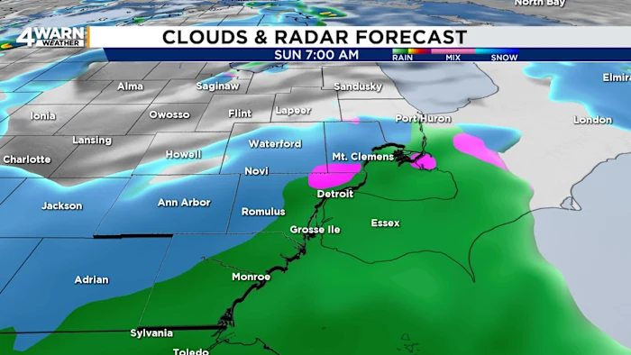
Metro Detroit’s first snowfall of the season arrives Sunday Metro Detroit will see its first snowfall of the season late Saturday night into Sunday, bringing minor accumulation to parts of Southeast Michigan. While many roads will remain just wet thanks to warmer ground temperatures, a few slick spots may develop—especially on bridges, overpasses, decks, and untreated surfaces. Drivers should slow down and allow extra time Sunday morning. A rain-snow mix will develop overnight and continue through Sunday. Most communities will see little to no accumulation. Communities north of I-696 and west of I-275 have the better chance of picking up light accumulation. Totals will generally remain minor, though a coating to around a half-inch is possible on colder surfaces. After temperatures near freezing on Sunday morning, highs will range from the upper-30s to near 40 degrees. The colder readings will be to the north and slightly milder temperatures closer to Detroit and areas south. Any snow that falls will be more likely to stick on vehicles, grassy areas, and elevated surfaces that cool faster. Roads should largely stay wet, but localized slick spots remain possible. Sunday night stays mostly cloudy with lingering flurries as temperatures settle into the mid-20s to lower-30s. Monday Lake-effect snow showers may continue at times Monday. Highs will only reach the mid-30s to lower-40s, several degrees below average for early November. Additional accumulation looks minimal, but quick bursts of snow could reduce visibility on occasion. Veterans Day Conditions begin to dry out Tuesday for Veterans Day, though temperatures remain on the cool side. Highs are expected to be around 40 degrees. Looking Ahead More noticeable warming arrives Wednesday and Thursday, with highs recovering into the mid-40s to near 50, though a chance of rain returns Thursday. By Friday, skies trend partly sunny and temperatures climb again toward the upper-40s. The region will stay cooler than normal through much of the week. Typical highs for this time of year are in the lower-50s, with average lows in the mid-30s. As this first round of snow arrives, remember to drive cautiously, leave extra space, and allow for slower travel. Even light snow can create travel issues, especially early in the season when drivers are readjusting to winter conditions. The average date for the season’s first measurable snowfall, with at least one-tenth of an inch, in Detroit is Nov. 16. Snap photos of the first snow of the season and share them with Local 4 using MIPics. Remember to download the free 4Warn weather app -- it’s easily one of the best in the nation. Just search your app store under WDIV, and it’s right there, available for both iPhones and Androids! Or click the appropriate link below.