Copyright newsweek
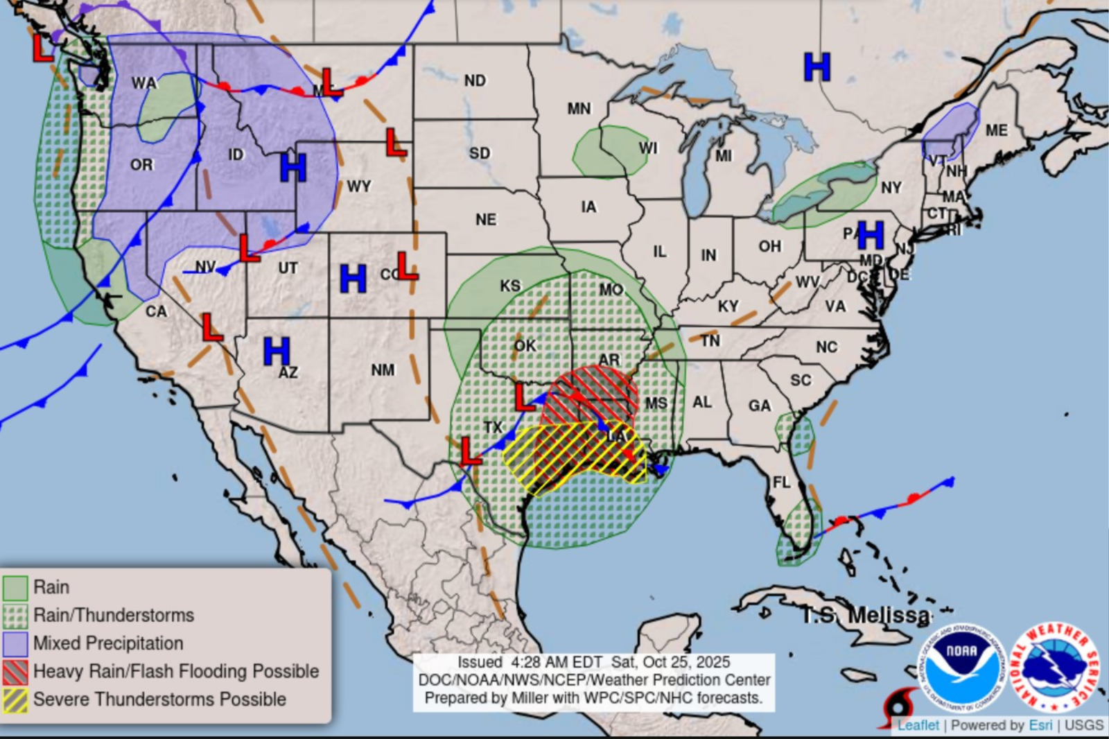
Severe storms and heavy rain swept through Texas and the neighboring states of Louisiana and Arkansas on Friday, triggering flash flooding, damaging winds and widespread event cancellations. Meteorologists forecast continued threats into the weekend, as several inches of rain and the risk of severe storms persisted from eastern Texas through the Lower Mississippi Valley, putting millions at risk of hazardous weather conditions. Newsweek reached out to the National Weather Service (NWS) by email on Saturday for more information. Why it Matters Heavy rainfall has already inundated parts of Texas, generating localized flash flood emergencies and dangerous travel conditions. For residents in flood-prone regions of Texas, Louisiana, and Arkansas, the threat sparked concerns about property damage, community safety and disrupted fall activities. The abrupt changes serve as a reminder of how volatile late-season storms can disrupt life across the South and central U.S., as well as the importance of severe weather preparedness. The severe weather and flood threat comes as Texas continues to recover from a deadly storm on the July Fourth weekend that took the lives of at least 135 people, including dozens of children attending Camp Mystic along the Guadalupe River. A map from the National Weather Service (NWS) shows which states will be impacted by severe weather Saturday. What To Know The NWS Weather Prediction Center forecast ongoing showers and thunderstorms from the Southern Plains into the Lower Mississippi Valley, extending to midnight on Saturday, with rainfall rates reaching as high as 2 inches per hour in some areas and localized totals between 3 and 5 inches. A slight risk of excessive rainfall and severe weather was declared for key regions in eastern Texas, Louisiana and Arkansas, increasing the threat of flash flooding and severe thunderstorms, including large hail, damaging winds and possible tornadoes. In Texas, heavy rain started on Friday night into early Saturday, moving from west to east across Central Texas before tracking into East Texas and neighboring states. Urban and river flooding affected several communities, leading the NWS to issue flood watches for Central and Southeast Texas, including major metros like Austin and San Antonio, through Saturday afternoon. Authorities strongly discouraged non-essential travel during periods of peak rainfall. On Friday, significant flooding impacted parts of Texas, with local reports of inundated roads and stranded vehicles as strong storms moved through in the overnight hours. Emergency responders managed multiple calls for water rescues and urban flooding. More storms are expected today, esp. south of I-20, where widespread storms and a large hail threat exists!A Flood watch has been issued for most areas south of I-20 and east of I-35!A slight risk is also in place for severe storms!Stay weather aware again today!#txwx pic.twitter.com/2Wr16SX8Lc— North Texas Weather Center (@ntexasweather) October 25, 2025 Thunderstorms produced hail and damaging winds, further compounding hazards for residents. The severity of the flooding in urban and rural areas led to temporary closures and warnings about flash flooding along rivers, creeks and streams, especially in Central Texas sectors from Austin through the ArkLaTex region. As storms threatened Central Texas, organizers and school districts canceled or changed the timing of several public and school events, including multiple high school football games and Halloween events. Conditions are expected to improve by Sunday as the cold front responsible for the severe weather pushed eastwards. The NWS forecast cooler and drier weather across affected regions by Sunday and Monday, with morning lows dipping into the 50s and daytime highs settling into the 60s through much of the Southeast and Central Plains. A more significant cold front was predicted to move through Texas by Tuesday, potentially bringing even cooler temperatures by the middle of the week. What People Are Saying Pete Delkus, WFFA Meteorologist said in a post on X on Saturday: A Flood Watch is in place until 10 p.m. today. This does not include DFW. Areas to the east, south and southeast of DFW could see an additional 1-2 inches of rain with isolated higher amounts this afternoon and evening.” The National Weather Service’s Weather Prediction Center said in its forecast discussion on Friday: “The combination of an energetic upper-wave and a surface frontal system supports multiple organized thunderstorms … Rain rates could be upwards of 2" per hour, leading to potential rainfall totals of 3-5 inches. A Slight Risk of Excessive Rainfall affects areas from eastern Texas through the ArkLaTex to the Lower Mississippi Valley.” What Happens Next Storms are forecast to exit Central and East Texas by late Saturday, with weather models predicting drier and...