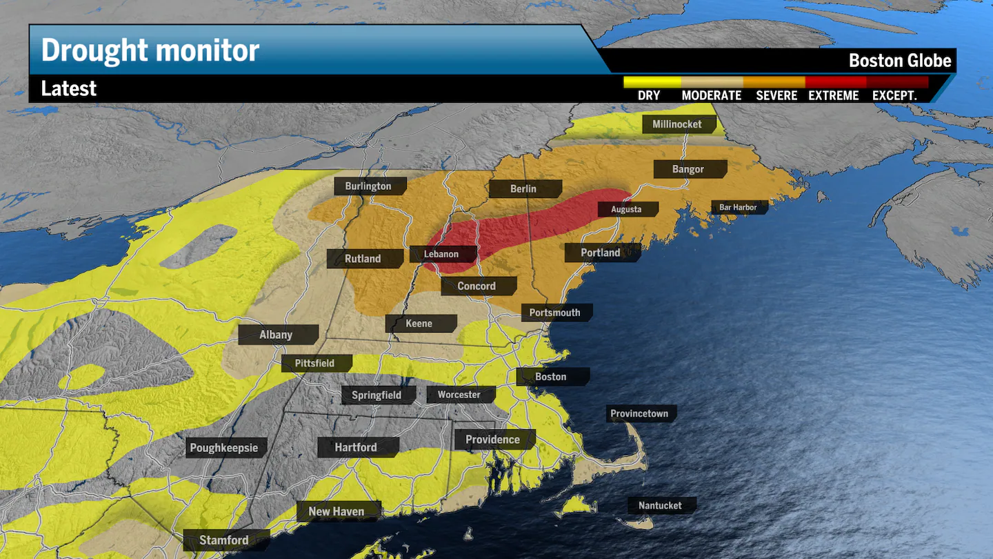
Another week has passed with little to no rainfall across New England, expanding “extreme” drought to nearly a quarter of New Hampshire as the dry weather worsens conditions in Maine and Vermont. Nearly all of New England is either in some stage of drought or abnormally dry, according to the latest U.S. Drought Monitor, increasing the risk for groundwater shortages and wildfires across the region — very reminiscent of last fall.
Despite one night of rainfall this week that totaled over an inch or two in parts of Southeastern Massachusetts and the Cape, New England will need more than just one significant rainstorm to pull us out of a nearly yearlong water deficit in those regions.
“We’re approaching the peak of last year’s rainfall deficit and groundwater storage levels,” said David Boutt, professor of hydrogeology at UMass Amherst. “Plus, this is the time of year when we’re naturally in a negative water balance from the combination of growing season and little to no precipitation.”
Advertisement
Last year, New England saw the fourth driest summer on record. An average of 8 inches of rainfall fell, more than 4 inches below the 30-year average and the lowest level since 1949.
Thankfully, we came off a decently wet spring, which has allowed for groundwater and streamflow levels to manage through this particularly aggressive drought. But unless we see some consistent rainfall soon, groundwater supplies and streamflows may turn dangerously low. We’ve already seen streamflows drop dramatically across Northern New England, and with very little moisture in the soil, New England will be prone to wildfire risks into the weekend as high pressure spreads very dry air across the region.
Advertisement
For Boston and most of Massachusetts, including Cape Cod, the drought has also worsened but not to the same extent as the northern tier. State officials have been urging residents to follow local water restrictions and be careful of outdoor fire risks.
Three-month precipitation deficits remain widespread, with much of the state receiving only 40 to 80 percent of normal rainfall, officials said.
The reason for the lack of rain lies in the position of the jet stream over the last few months. The jet stream is the highway most storms travel along across the country.
During the summer, the jet stream was positioned frequently over southern Canada, bringing storms north of New England. The case this month? The jet stream veered to the south of New England, sending storms through the Mid-Atlantic and keeping New England both dry and cooler than average.
Our next chance of rain
The jet stream will stay to the south of New England through the weekend and into next week. Our next rain chances enter the picture mid- to late next week, but all indicators show that rainfall will be light and scarce.
For the season, most of New England is running a rainfall deficit already through the first half of September, with parts of Northern New England nearly 2 inches behind the monthly average.
Fall usually brings variability into the picture, increasing rain totals throughout October, but hopefully, the region can see some relief before the end of September.
Sign up here for our daily Globe Weather Forecast that will arrive straight into your inbox bright and early each weekday morning.
Advertisement
Ken Mahan can be reached at ken.mahan@globe.com. Follow him on Instagram @kenmahantheweatherman.