By Editor,Stacy Liberatore
Copyright dailymail
Hurricane Gabrielle threat looms in Atlantic as forecasters raise formation odds
READ MORE: Millions of Americans warned as new hurricane forecast pins exact date for Atlantic storm threats
By STACY LIBERATORE, US SCIENCE & TECHNOLOGY EDITOR
Published: 13:36 BST, 16 September 2025 | Updated: 16:56 BST, 16 September 2025
A developing tropical system in the Atlantic Ocean is gaining attention as it shows a 90 percent chance of cyclone formation over the next seven days.
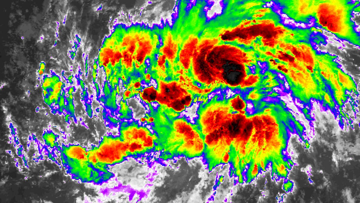
The system, designated Invest AL92, is currently located in the central tropical Atlantic, moving west at 17mph.
Fox Weather meteorologist Ian Oliver told USA Today: ‘This disturbance is very likely to organize into Tropical Storm Gabrielle sometime during the middle or latter part of this work week, and it will likely continue to intensify into a hurricane.’
This system has become better organized since Monday and is expected to move through a favorable environment for further development.
The National Hurricane Center (NHC) said on Tuesday that a tropical depression or tropical storm is likely to form in the next day or two.
A tropical depression is a low-pressure system with organized thunderstorms and winds of 38mph or less. While a tropical storm is stronger, with winds between 39 and 73 mph, it is given an official name as it moves closer to becoming a hurricane.
Forecast models have strongly suggested the storm will turn north well before reaching the Caribbean, though some effects cannot be completely ruled out.
Since this storm has not fully developed, meteorologists have extra uncertainty, so it is wise to stay alert.
The system, designated Invest AL92, now has a 90 percent chance of developing into a cyclone over the next seven days. Meteorologists believe it could even intensify into a hurricane
The formation of a new tropical cyclone would end an unusually quiet stretch in the Atlantic Basin, which included the hurricane season’s peak on September 10.
However, forecasters warned that tropical activity is likely to ramp up over the next few weeks as conditions in the Atlantic become more favorable for development.
Although the climatological peak of the Atlantic hurricane season has passed, about 60 percent of tropical activity typically occurs after September 10, according to the NHC.
Jennifer Francis, an atmospheric scientist at the Woodwell Climate Research Center, told ABC News last week that waters in the Gulf and Caribbean are currently ‘very warm.’
Historically, roughly two-thirds of Atlantic hurricane activity occurs between August 20 and October 10, and NOAA predicted above-normal activity for the rest of the season in its August forecast.
The latest Global Tropics Hazards and Benefits Outlook from the Climate Prediction Center (CPC), released last week, predicted a heightened risk of tropical cyclone formation starting September 17.
Models indicated a 40 to 60 percent chance of storms developing across the central Atlantic near the Cape Verde Islands, tracking west toward the Lesser Antilles with potential to affect the wider Atlantic basin.
Forecasters also predicted a 20 to 40 percent probability of tropical cyclones forming in the northwest Caribbean and Gulf of America over the next two weeks.
The system is currently located in the central tropical Atlantic, moving west at 17mph
The National Hurricane Center is tracing the system (shown in red), warning it will likely develop into a tropical depression or tropical storm in the next few days
The ‘inevitable’ US disasters that keep scientists up at night
Odds in the eastern Atlantic are expected to rise slightly, as a particularly strong tropical wave projected off the coast of Africa around September 20 could boost formation chances to 40 to 60 percent.
During hurricane season, roughly 40 to 60 tropical waves move westward across the Atlantic.
Typically, about one in five of these waves develops into a tropical storm or hurricane, though the likelihood can rise significantly during the season’s peak periods of heightened activity.
AccuWeather lead hurricane expert Alex DaSilva said: ‘We expect several tropical waves from Africa to push off the western coast in the next few weeks, posing a risk for Atlantic hurricane development.’
The Atlantic hurricane season has seen only Hurricane Erin, a long-lived and very powerful storm.
Erin was the fifth named storm, but the first and only hurricane of the season so far.
The hurricane season runs from May 15 until November 30, making it two weeks longer than the Atlantic hurricane season.
It developed as a tropical wave on August 11 and reached Category 5 hurricane status by August 16
Forecast models have strongly suggested the storm will turn north well before reaching the Caribbean, though some effects cannot be completely ruled out
From August 19 to 21, Erin grew larger while maintaining its strength as it tracked parallel to the US East Coast.
By August 22, the storm turned eastward and began losing its tropical characteristics, completing its transition to an extratropical system later that day.
The National Oceanic and Atmospheric Administration (NOAA) has predicted a ‘below-normal season’ for the eastern Pacific, with 12 to 18 named storms, five to 10 hurricanes, and up to five major hurricanes.
Share or comment on this article:
Hurricane Gabrielle threat looms in Atlantic as forecasters raise formation odds
Add comment