Copyright breitbart
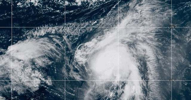
Meteorologists are keeping a sharp eye on second storm brewing in the Atlantic that could impact, or even join, Hurricane Humberto as it becomes a Category 3 storm on a path toward the southeastern coast of the United States. The National Hurricane Center (NHC) announced that Humberto became a Category 1 storm Friday morning and predicts by Saturday that will rise to a Category 3 with sustained winds exceeding 110 mph. Meanwhile, another tropical storm, currently designated 94L and expected to be named “Imelda,” is gathering strength in the Caribbean between Cuba and the Dominican Republic. According to AccuWeather hurricane forecaster Alex DaSilva and other meteorologists, the two storms could alter each other’s predicted path or even become a super storm as the result of what’s called the Fujiwhara Effect. As of Friday, Humberto was projected to hold the Category 3 strength until at least Tuesday as it nears the mid-Atlantic states, including South Carolina, North Carolina, and Virginia. It is not expected to make landfall, according to forecast models. Models predict Imelda, once it becomes a tropical storm, will make landfall in the southeast with a potential direct strike on Florida, Georgia, or the Carolinas, bringing the risk of severe flooding, the Daily Mail reported Friday. However, forecasters continue to watch what impact the storms may have on each other. On Thursday, they were 600 miles apart. The Fujiwhara Effect is not a frequent phenomenon. There only four instances of major storms combining near the East Coast since 1995, according to the Mail. The most powerful hurricane of the 2025 season so far was Erin, a Category 5 storm in August that brought storm surges and flooding to the East Coast despite remaining 200 miles offshore.