Copyright Newsweek
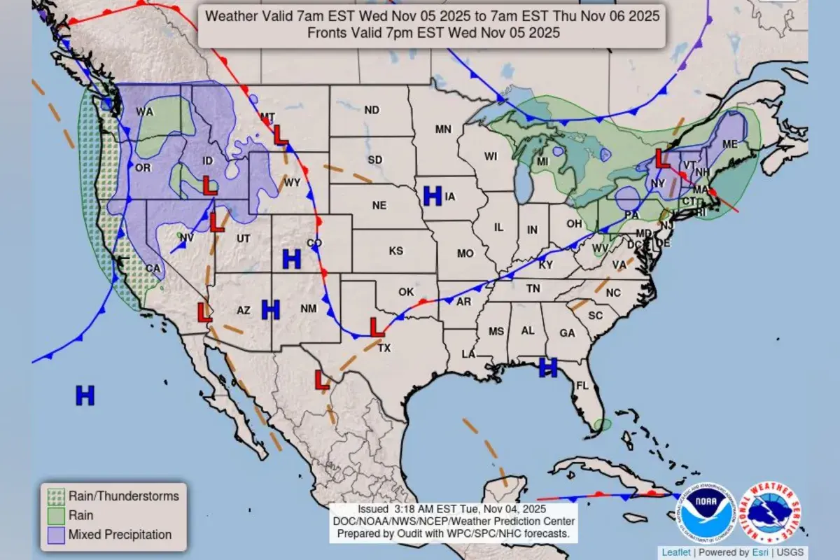
A forecast map shared by the National Weather Service (NWS) shows where “a strong atmospheric river” could continue to bring moderate to heavy rainfall, along with possible flooding, strong winds, and mountain snow to parts of the Northwest United States. Why It Matters The NWS previously issued warnings across northern and central California earlier this week, as an atmospheric river caused heavy rain, damaging winds, and mountain snow. AccuWeather meteorologist Heather Zehr told Newsweek that northwestern coastal California and the southwest Oregon coast have seen two to three inches of rain, with locally higher totals. “Since this latest round of stormy weather began early this week, rain totals have been lower in Washington and Idaho, especially in the valleys. Most of the rain has been focused on Oregon and down into northwestern California,” Zehr said. Some areas in the southern Washington Cascades have received over an inch of rain, and up to about two inches in Oregon, according to the meteorologist. What To Know According to a map shared by the NWS, rain and thunderstorms are possible along much of the California coastline, as well as the coasts of Oregon and Washington Wednesday and into early Thursday. Parts of these three states, as well as areas in Idaho, Montana, Nevada, Utah, and western Wyoming, were expected to experience mixed precipitation. This week, Zehr said additional rainfall of one to two inches would be common, though two to four inches could occur in the coastal mountains. Gusts on Wednesday could be between 40-50 miles per hour in western portions of Washington, Oregon, and California down to the San Francisco Bay Area, as well as over higher terrain inland, according to Zehr. “There won't be much of a break before the next storm brings another round of rain and wind for Thursday into Friday. The worst conditions will be on Thursday, then snow levels are lowering on Friday in the Northwest,” Zehr said. “We expect most of the snow to be above pass level but there can be some mixing of rain and snow with slippery travel.” The National Oceanic and Atmospheric Administration (NOAA) describes atmospheric rivers as long, narrow bands of moisture in the sky that transport most of the water vapor outside the tropics. On average, one carries an amount of water vapor roughly equivalent to the average flow of water at the mouth of the Mississippi River, with particularly strong atmospheric rivers capable of moving up to 15 times more. When these systems reach land, they often release moisture as rain or snow. The most powerful atmospheric rivers can unleash extreme rainfall and flooding, trigger mudslides and cause major damage—especially when they stall over flood-prone regions. However, most are weaker and can deliver beneficial precipitation to water supplies, according to NOAA. What People Are Saying AccuWeather meteorologist Heather Zehr told Newsweek: “There will finally be a break in the wet weather this weekend before some showers try to return early next week. That would not be significant rainfall.” The NWS said in a forecast on Wednesday: The most active weather lies across portions of the West, with special emphasis near the coast as a couple of atmospheric rivers associated with a couple different frontal systems periodically bring heavy rainfall to portions of the Northwest and northern California which gets wrung out by the coastal ranges. "While the most significant rainfall/highest wind threat fades during the day today, a limited severe weather risk exists in the unstable post-frontal airmass this afternoon as cool air aloft interacts with the heating of the day. Precipitation does continue and eventually picks back up some in intensity Thursday evening into Friday morning, though thunderstorms are expected to be fewer and farther between." What Happens Next The NWS issues regular forecast updates on the agency’s website and social media channels.