By Simon Boxall
Copyright caymancompass
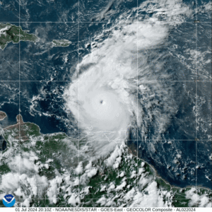
For residents in the Cayman Islands, knowing whether a storm or hurricane will enter the Caribbean Sea and possibly pose a threat is critical information.
Advance knowledge of the likely path and intensity of a hurricane can trigger a whole set of preparedness and response actions – in some instances, days before the possibility of life-or property-threatening impacts.
To monitor the threat of a storm, forecasters at the National Hurricane Center, as well as the team at the Cayman Islands National Weather Service, have long leaned on a handful of numerical weather prediction systems – each with known strengths and predictable quirks. In recent years, a new player, machine-learning AI, has dramatically improved medium-range forecasts, prompting questions about whether traditional models will be supplanted.
Phil Klotzbach, senior research scientist at the department of atmospheric sciences at Colorado State University, told the Compass, “The new AI models are a valuable new tool in the forecaster’s toolbox,” adding, “I’ve been including both the ECMWF AI model and the Google DeepMind model in our publicly available two-week forecasts.”
Based on the National Hurricane Center’s 2024 Forecast Verification Report, overall, the NHC’s official forecast outperformed all of the individual models and made the most-accurate Atlantic cyclone track forecasts, in almost all cases, at every time interval going out to five days.
Other models that tropical weather forecasters most respect include:
ECMWF (European Centre for Medium-Range Weather Forecasts) – Widely regarded as the global gold standard for track forecasts, the ECMWF typically leads the field on one-to-seven-day track accuracy. It can, however, underrepresent some fast, small-scale processes that drive rapid intensification.
GFS (NOAA’s Global Forecast System, now GFSv16) – The US operational workhorse has improved markedly; it often produces comparable tracks to ECMWF at longer lead times. Operational assessments find a modest under-forecast intensity bias at longer lead times in several of these ensembles, even as track errors shrink with upgrades.
ICON (German DWD)/UKMET) – ICON and the UK Met Office global model are increasingly competitive on track, with ICON sometimes resolving early cyclogenesis features that other global models miss. UKMET and ICON both have tendencies that depend on season and steering flow regimes, so forecasters rely on multi-model consensus.
AI enters the picture
Google’s DeepMind’s GraphCast (and follow-on systems such as Google’s Weatherlab) have shown the ability to produce medium-range forecasts faster and in some metrics more accurately than other systems – and recent pilot work suggests AI can improve track and even some intensity forecasts when trained on decades of reanalysis and model output. Early 2024–2025 reporting and papers show AI beating ECMWF on many metrics up to 10–15 days while producing ensembles orders of magnitude faster.
But AI has limits. Pure data-driven systems can struggle with physical realism (why something happens) and rare events outside their training distribution (for example, explosive rapid intensification). That has prompted hybrid approaches – blending physics-based cores with machine-learned components – and operational partnerships between AI labs and forecasting agencies.
Recent announcements indicate experimental AI outputs are already being explored in US operational workflows. NOAA’s communications public affairs officer, Maria Torres told Compass Media, “It is too early to make an assessment of the AI models’ performance. NHC has begun to integrate these new AI models into our workflows so that they can be evaluated in parallel to other models. However, we feel it is important to gather a large sample before assessing the general performance of new models.”
For the Cayman Islands and the wider Caribbean, at the present time, the best approach remains multi-model synthesis – including AI – while also keeping a close eye on the information provided by local sources such as the Cayman Islands National Weather Service and Hazard Management Cayman Islands.
These local agencies have an understanding and appreciation of the unique context of the Cayman Islands, including information about coastal elevation and contours, known areas that flood, and historical knowledge gained from previous cyclone impacts.