Huge tornado strikes country town in NSW as wild storms lash Australia’s east coast amid warnings another wet summer is on the way
By Charlotte McIntyre,Editor,Max Aldred
Copyright dailymail
Tornado spotted in New South Wales
Warnings issued for Young and Cowra
READ MORE: Rain bomb strikes Australia’s east coast – here’s how long it’ll last
By CHARLOTTE MCINTYRE, NEWS REPORTER, AUSTRALIA and MAX ALDRED, NEWS REPORTER, AUSTRALIA
Published: 08:30 BST, 10 September 2025 | Updated: 09:33 BST, 10 September 2025
A tornado has been spotted in central New South Wales as a severe weather warning has been issued for the area.
Several storms swept across the state on Wednesday afternoon which led to the Bureau of Meteorology (BOM) releasing a tornado warning for Young and Cowra, and the surrounding area.
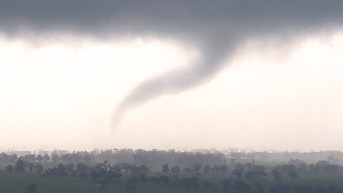
Chilling footage captured about 3.30pm by a NSW Rural Fire Service tower, which looks out to the northwest of Young, showed a tornado piercing the skyline.
‘The Rural Fire Service fire tower cameras picked up what was believed to be a very significant weather cell building to the northwest of Young, around [an area] called Tubbul,’ NSW RFS inspector James Morris said.
‘That fire tower camera picked up the cell, which was then sent through directly to our fire behaviour analyst team through to the Bureau of Meteorology, which we believe provided notification and warning of what we believe would be a tornado cell forming in in that area.’
Mr Morris said there have been no reports of any injuries or significant damage at this stage.
The BOM has since cancelled the tornado warning but residents have been urged to stay indoors with severe weather still likely.
A cold front attached to a low pressure system was moving eastwards through central parts of NSW, the BOM recorded.
Footage captured about 3.30pm by a NSW RFS tower showed a tornado piercing the skyline
Millions of Aussies woke up to rain in NSW (pictured, a commuter in Sydney’s CBD)
This has resulted in severe thunderstorms on Wednesday afternoon and evening.
‘Very dangerous thunderstorms are likely to produce tornadoes, destructive winds, large hailstones and heavy rainfall that may lead to flash flooding over the next several hours in parts of the Central Tablelands, South West Slopes, Southern Tablelands and Central West Slopes and Plains districts,’ the BOM’s warning issued just before 4pm said.
‘Locations which may be affected include Young and Cowra.’
Meanwhile, Australia is on the verge of its fifth La Nina event in six years.
La Nina is a climate cycle known for changing the typical weather pattern and increasing the continent’s odds of rain and flooding.
Looking at the latest models, there is a substantial chance that La Nina could develop in the spring months.
This means there are significant chances of above normal rainfall for the rest of the year, especially in Australia’s east, centre and north.
Millions of Aussies experienced an onslaught of wet weather on Wednesday, with the worst yet to come.
A tornado was spotted to the northwest of Young, near Tubbul, on Wednesday
Relatively cool waters in the middle of the Pacific Ocean in blue and warm waters near Australia is a sign another La Nina event could be on its way
A low-pressure system developed over South Australia on Tuesday before travelling eastward and blanketing NSW.
The heaviest rain fell in the Central Tablelands overnight on Wednesday with Mudgee and Orange receiving falls of 60mm and 53mm respectively.
There were also strong wind gusts of almost 90km/h.
Bureau of Meteorology Senior Meteorologist Angus Hines told Daily Mail the low-pressure system continued to be the ‘main engine’ for the wet weather.
In southern NSW, severe weather warnings were issued for the Illawarra, South Coast and Southern Tablelands on Wednesday.
Heavy rainfall is expected in the area.
A gale warning is current for the Illawarra and Batemans coast while lesser wind warnings are in place for other stretches of the coastline.
The Byron Coast, Coffs Coast, Macquarie Coast, Hunter Coast, Sydney Coast and the Eden Coast have been put on alert for strong winds, which are expected to develop into a gale warning on Wednesday for many of the regions.
The ‘complex low’ over southeastern NSW is expected to move offshore by Thursday morning, with heavy rain and potential flash floods to follow.
‘We’re seeing a very windy few days,’ Mr Hines told Daily Mail.
‘It’s really ramping up and will strengthen today and overnight… the system will be at its strongest when it crosses the coast overnight and tomorrow morning.
‘For those coastal areas the strongest wind does depend on the makeup of the weather system, and can occur when the centre of the system gets closer.
‘Those-low pressure areas can tighten up and intensify when they move away from the coast and there’s nothing in their path to impede it.’
Share or comment on this article:
Huge tornado strikes country town in NSW as wild storms lash Australia’s east coast amid warnings another wet summer is on the way
Add comment