CHARLESTON — Local officials are prepping ahead of forecasts calling for a wet weekend and potential impacts from an approaching tropical disturbance.
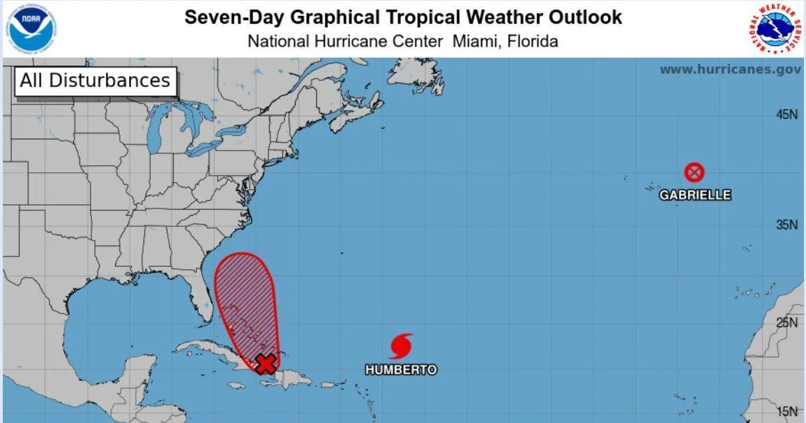
The National Weather Service is monitoring a storm just east of Cuba that forecasters give an 80 percent chance of forming into a tropical depression within the next 48 hours, and a 90 percent chance of developing into a named storm over the next seven days.
“There is a lot of uncertainty though,” Daniel Flessas, an emergency management specialist for the city of Charleston. He provided a briefing for City Council during a Sept. 26 meeting based on the latest information from the National Weather Service.
“Prepare now,” he said. “Uncertainty doesn’t mean don’t prepare.”
Ahead of any impacts from a potential storm, separate forecasts call for between ½ to 1½ inches of rainfall on Sept. 27, but totals could reach as high was 2 to 3 inches in the Charleston area.
“We’re going to get a lot of rain this weekend before this disturbance forms, that could soften the ground and increase the probability of trees coming down and the like,” Mayor Williams Cogswell cautioned.
The local weather service office presented officials three scenarios, Flessas told the council. The first model has storm impacts anywhere from Savannah to South Carolina’s northern border, though Flessas did not say when exactly those would start.
The second scenario has the storm headed toward Charleston, stalling just off the coast before veering back out to sea.
The third, least likely model shows the storm would sweep off the coast completely.
In Charleston, pumps are being deployed in flood-prone areas, police are staging barricades, the Fire Department is readying its high-water vehicles, and the Public Works department is working on plan to make sandbags.
Cogswell said he’s ordered the city’s retention lakes lowered, including Lake Dotterer.
“Even though this has not formed yet, we are treating it as if we are expecting some kind of impact,” said Fire Chief Mike Julazadeh.
Use the weekend to prep your family, he advised. That includes assembling emergency kits, checking the county’s Hurricane Guide and knowing the geography of your evacuation zone.
Areas along the immediate coast including Seabrook Island, Kiawah Island, Folly Beach, Sullivan’s Island, Isle of Palms, Dewees Island, and Edisto Island are in Zone A. Downtown Charleston, West Ashley and Mount Pleasant are in Zone B. Areas further north are in Zone C.
Folly Beach announced via Facebook it will close city hall indefinitely beginning at noon Sept. 26 to prepare for potential storm-related impacts as two systems churn in the Atlantic.
Folly leaders will meet at 4 p.m. with plans to issue an emergency declaration, Mayor Tim Goodwin said.
Declaring a local state of emergency gives the mayor power to make decisions without a requiring a full vote of council. It also allows the city to open its emergency operations center and makes the city eligible for state or federal financial assistance later on, Goodwin said Sept. 26.
The city of Isle of Palms will begin its self-service sandbag operations at the Public Safety Building on JC Long Boulevard starting at noon Sept. 26, police Sgt. Matt Storen said. Residents can fill up to 10 bags per household with sand.
Sandbags act as a barrier to block or redirect water away from an area. Though sandbags don’t fully seal out water, they are typically propped up against doorways or garages to help stave off floodwaters.
In North Charleston, residents can pick up sandbags at three drive-through locations across the city starting at 11 a.m. on Sept. 27. Proof of North Charleston residency must be provided. Residents will pull up to the distribution site and city staff will load up to six filled sandbags into vehicles until supplies last.
Gussie Greene Community Center, 2008 Success St.
North Charleston Athletic Center, 5794 Casper Padgett Way
North Charleston Aquatic Center, 8610 Patriot Blvd.
Dorchester County is offering four sandbag distributions from 5 p.m. to dusk on Friday, September 26 at the following locations.
Harleyville Town Hall, 122 W Main St.
Ridgeville Town Hall, 105 School St.
Davis-Bailey Park, 5190 E Jim Bilton Boulevard
Oakbrook Middle School, 286 Old Fort Drive
An additional location for sandbag distribution will be open for Dorchester residents on Sept. 27 from 9 a.m. to 1 p.m. at the parking lot next to Memorial Stadium/John McKissick Field in Summerville. Bags will be available on a first-come, first-serve basis, with a limit of 10 per household or business.
Residents are encouraged to keep sandbags for future storms, instead of throwing them away after.
The city of North Charleston is closely monitoring the storm and coordinating efforts with the emergency management departments in Charleston and Dorchester counties, according to a Sept. 26 announcement.
City offices and trash collection are operating normally until further notice. Municipal Court will be closed Sept. 29 and 30. Bond hearings will still take place daily. Information on rescheduled court dates will be sent in the mail.
All recreational activities are canceled from Sept. 27 through 30, including athletics, senior center programs and cultural arts activities. All recreational facilities will be closed through Sept. 30.