By Akshit Sangomla
Copyright downtoearth
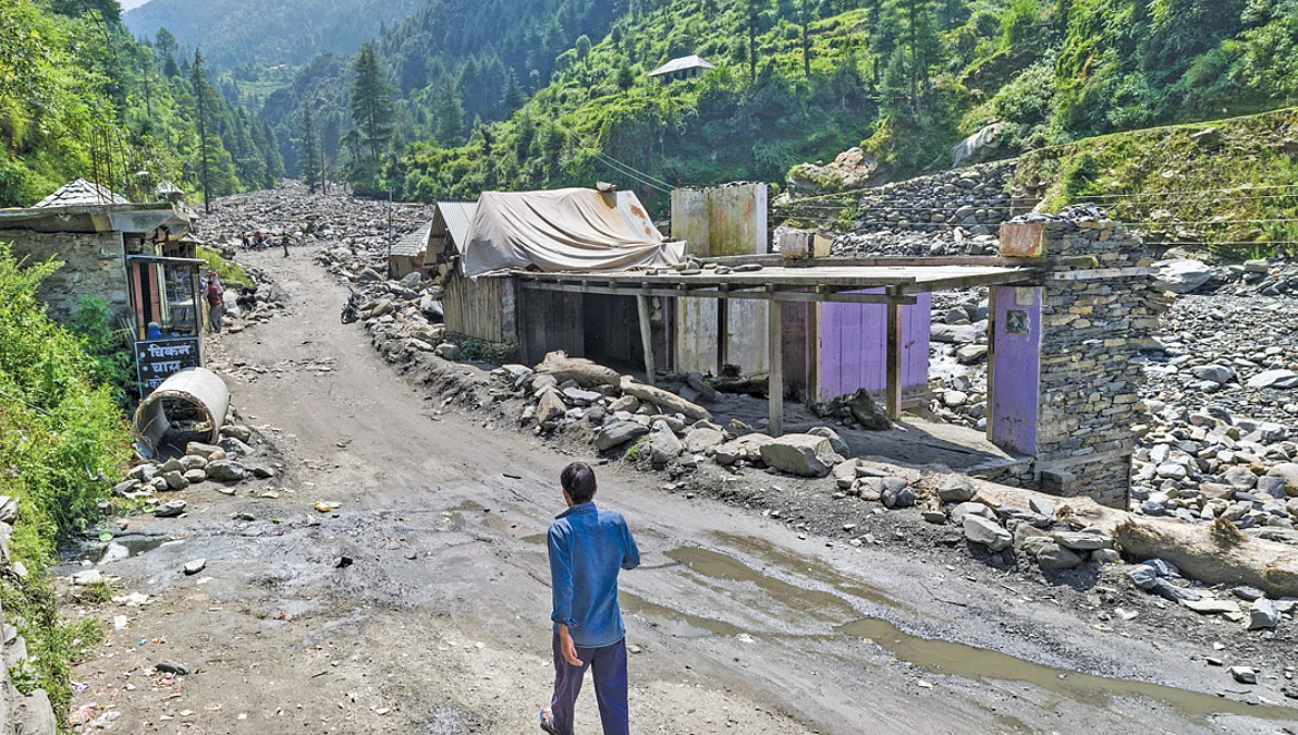
For those living in the Western Himalayan region, there was nothing august about August 2025, or the two months preceding it. The states of Uttarakhand and Himachal Pradesh and the Union Territories (UTs) of Jammu and Kashmir and Ladakh were battered by a series of extreme weather events, from heavy rains to cloudbursts to flash floods, as soon as the monsoon season officially began on May 24. The chain of tragedies started as early as May 27, when a cloudburst triggered flash floods and landslides in north Kashmir’s Kupwara district and damaged the under-construction 12 MW Karnah Hydro Power Project. From that point on, nearly every week brought one or more disasters. An analysis by Down To Earth (DTE) shows that between June 1 and August 31, these four states and UTs experienced extreme weather events on 88 out of 92 days and recorded 506 deaths. In other words, they accounted for nearly one-quarter of all monsoon-related fatalities across the country during that period. In fact, the number of days during which the four states and UTs have experienced extreme events (which include heavy rains, floods, landslides, cloudburst, lightning and storms) is higher than in any other monsoon season since 2022. In Jammu and Kashmir, the proportion of days with extreme weather events during the first three months of the monsoon season has increased from 10.8 per cent in 2022 to 51 per cent. The proportion of extreme weather days have almost doubled in Himachal Pradesh, Uttarakhand and Ladakh. Invariably, the main cause of the disasters has been the intensity of extreme rain. Between June 1 and September 5, three of these four states and UTs received “excess” rainfall (20-59 per cent surplus rainfall than normal, as categorised by the India Meteorological Department or IMD) and one experienced “large excess” rainfall (60 per cent surplus rainfall than normal). Uttarakhand received 24 per cent excess rainfall, while Himachal Pradesh and Jammu and Kashmir received 47 per cent and 44 per cent excess rainfall respectively. Ladakh, the cold desert situated in the Himalayas’ rain shadow area, received an astounding 434 per cent large excess rainfall. Most of this precipitation occurred in a very short period of time, resulting in flash floods and landslides. Consider this. On July 1, Mandi district of Himachal Pradesh received almost 2,000 per cent surplus rainfall. Nearly 13 per cent of Mandi’s average seasonal monsoon rainfall fell in just 24 hours, creating a flood-like situation across the district. About 14 people lost their lives. A similar disaster unfolded in Uttarakhand which between August 5 and 6, received 421 per cent above average rainfall, says Akshay Deoras, research scientist at the National Centre for Atmospheric Science and Department of Meteorology, University of Reading, UK. This led to massive floods and deadly mudslides. “On August 5 alone, Uttarkashi district, the epicentre of the deadly mudslide, recorded over 100 mm of rain in around seven hours, while areas surrounding the disaster location reportedly saw more than 400 mm rainfall within a few hours. This is nearly two-thirds of the total rainfall London Heathrow receives in an entire year,” says Deoras. “The steep terrain around Dharali village, where the tragedy occurred, acted like a chute, accelerating mud and debris into a deadly rush downhill,” he adds.The intensity of rainfall in the Western Himalayas can be gauged from the fact that in just three weeks, Jammu and Kashmir’s cumulative rainfall for the season shifted from a deficit of 5 per cent to a 43 per cent surplus, in the week ending September 3. That week, between August 26 and 27, Jammu received 380 mm of rain in just 24 hours. Rivers burst their banks, bridges snapped and landslides roared down hillsides. At least 34 people died and over a dozen injured as the landslide struck the route to the Vaishno Devi shrine in Reasi district. The authorities had to escort down thousands of pilgrims and halt the yatra. A few days later, on August 30, landslides caused by cloudbursts in Ramban district blocked the National Highway-44, the only all-weather road connecting Jammu with Srinagar. Huge slopes collapsed, burying long stretches of the highway under mud and stones. “We were stuck for two nights on the highway with no food for our children,” says Irfan Ahmad, who was travelling from Jammu to Srinagar. By early September, the disasters had spread across the Kashmir Valley. The Jhelum and Chenab crossed danger marks, flooding neighbourhoods in Srinagar. By August 31, more than 200 people had died in the state due to monsoon-related disasters. Thousands were displaced, and many villages are no longer safe to live in.In the cold desert of Ladakh, the capital city Leh recorded 80.2 mm of rain in August—its highest monthly rainfall in over half a century. In the week ending August 27, the city received more than 19,000 per cent surplus rainfall. “At 37 mm, Leh also recorded the highest single-day rainfall in nearly a century; Kargil recorded 33 mm in 24 hours,” Sonam Lotus, director, Meteorological Centre Leh, tells DTE. The spell in August was not ideal as farmers were in the middle of harvesting their crops. The unusual downpour has also led to flash floods, soil erosion and caused damage to traditional housing structures, as the region’s soil is loose, topography fragile and ecology highly vulnerable, Lotus says..Hazardous shifts in wind patternsThe monsoon mayhem in the Western Himalayas is the result of a combination of weather systems, whose origin, movement, occurrence and interaction have been unusual this year. The southwest monsoon has been active this year over the entire country. But the rains in the northwest region have been exacerbated by the presence of three additional factors: untimely presence of western disturbances over north India; moisture-laden winds blowing from the Arabian Sea; and the northward deflection of monsoon low-pressure systems originating from the Bay of Bengal.Scientists DTE spoke with say that the increase in frequency of western disturbances during the monsoon period and the moisture influx from the Arabian Sea are relatively new occurrences and defy current scientific understanding.Let’s first analyse the anomalous behaviour of western disturbances this monsoon. This extratropical storm usually originates around the Mediterranean region and travels towards India via Iran, Afghanistan and Pakistan. Kieran Hunt, independent research fellow in tropical meteorology and artificial intelligence at the Natural Environment Research Council and professor at the University of Reading, both in the UK, tells DTE that most of the western disturbances actually originate over land downstream of Zagros mountains in Iran. Over Pakistan and India, these western disturbances induce cyclonic circulations and cause rainfall. They are most common between December and March, and bring the much needed winter and springtime precipitation to north India, particularly to the Western Himalayan region, whose high-elevational mountains are least favoured by southwest summer monsoon. Some 80 per cent of Western Himalayas’ precipitation is brought by western disturbances. They are thus crucial for winter crops like wheat in this region. Weather scientists tell DTE that four to six western disturbances affect India between December and March. Their occurrence is however rare during the monsoon season. “There are rarely two western disturbances in June and zero or one in July and August,” says Hunt. This means there should have been a maximum of four western disturbances during the entire four-month monsoon season. Instead, as many as 19 western disturbances have affected the country between the onset of the southwest monsoon on June 1 and September 7, when the magazine went to print. Analysis of IMD data shows that five of these western disturbances occurred in June, five in July, six in August and three just in the first week of September. The most recent western disturbance started affecting northwest India on September 6 and was active till the magazine went to print. Five of the 19 western disturbances were persistent and lasted for five to seven days. While it is unclear if more western disturbances will visit India in the remaining weeks of September, when the southwest monsoon starts to draw to a close, IMD has warned of surplus rainfall—109 per cent of long period average—for the entire country. The occurrence of western disturbances when the southwest monsoon system is active has led to catastrophic events in the past. This includes the 2013 Uttarakhand cloudburst that impacted Kedarnath valley, resulted in flash floods and landslides and killed more than 5,000 people. Scientists say in the past few years the frequency of western disturbances has increased during the summer as well as monsoon months. .Western disturbances seem to have developed a feverScientists hypothesise two reasons for the continued presence of western disturbances over north India. Their presence during the early monsoon season is because of the delayed retreat of the subtropical jet stream—a band of winds in the upper layers of the atmosphere that carries the western disturbances. This jet stream is kind of a balancing wind in the upper atmosphere that maintains the heat gradient between the equator and the North Pole. During the monsoon season, this jet stream shifts northwards, which allows the setting up of monsoon trough (an extended low pressure area around which most of the rainfall occurs during the season). But with the rapid warming of the Arctic region, the heat gradient between the equator and the North Pole is decreasing, leading to delayed retreat of the subtropical jet stream. Hunt also links the change in the jet steam to the differential heating over Tibetan Plateau. “What global warming has done is heat up Tibetan Plateau more than the surrounding regions. This changes the configuration, temperature gradient and changes the character of subtropical jet stream,” he says.However, most of the western disturbance systems remained active even after the retreat of subtropical jet stream. This could be linked to their origin. Most of the western disturbance systems active during the 2025 monsoon season have originated close to north Pakistan and north Afghanistan, shows IMD data analysed by DTE and corroborated by Raghu Murtugudde, retired professor at the Centre for Climate Studies, Indian Institute of Technology, Bombay and emeritus professor at the University of Maryland, US.Hunt agrees to the possibility. “My hypothesis is that there are different flavours of western disturbances,” says Hunt. The first flavour is the classical one that originates in the Mediterranean and surrounding regions and travel over Iran, Afghanistan and Pakistan towards India. The second flavour are known as Potential Vorticity (PV) cut-off lows, which are cold-core, low-pressure systems in the upper layers of the troposphere that get cut off from the Arctic jet stream and move towards the lower latitudes and look similar in shape to the classical western disturbances, says Hunt. “They move slowly, are stronger and have deeper convection and account for 10 per cent of the total western disturbances,” says Hunt. “The evidence of the increased number of western disturbances during the current monsoon season could be due to the increase of PV cut-off lows as they do not need the subtropical westerly jet stream to reach India. However, this needs to be further investigated,” he adds. .Unholy interactions worsens the crisisTo compound the situation, these western disturbances interacted with low-pressure areas and associated cyclonic circulations formed in the Bay of Bengal, which had strayed from their usual track and were moving northwards.The low-pressure areas or monsoon lows form mostly in the Bay of Bengal and rarely in the Arabian Sea. They then move westwards over central India, causing most of the rainfall over eastern, central and western regions of the country. “This monsoon, the low-pressure systems were steered northwards of their usual path because of a possible push from anomalous moisture-laden winds from the Arabian Sea,” says Murtugudde. While causes behind the influx of winds from the Arabian Sea need to be explored, studies have established that warming of West Asia and the temperature gradient with the Arabian Sea has enhanced convergence of moisture over the region. “Even the cumulative rain so far shows the signature of the northward shift in the low-level jet over the Arabian Sea (which is a crucial component of the Indian summer monsoon as it brings moist air from the Southern Indian Ocean to the Indian subcontinent). Note that the rainfall is generally deficit over the southern Western Ghats and peninsular India as compared to the northern Western Ghats and the northwest,” Murtugudde adds. Scientists tell DTE that at least two of the 19 western disturbances actively interacted with the northward moving low-pressure areas, and induced cyclonic circulations of their own. The first of these interactions occurred in the last week of August and the second in the first week of September. During these weeks, Himachal Pradesh, Jammu and Kashmir and Ladakh recorded rainfall that far exceeds IMD’s “large excess” category, which is defined as over 60 per cent surplus rainfall. The rainfall these states received during these weeks was two to three times more than the normal. Though Uttarakhand saw “normal” rainfall during the last week of August, it joined the “large excess” category by the next week. .Do we really know the mountains?In a changing climate, the nature of extreme weather events are also changing, requiring India to urgently improve its forecasting ability and bolster its warning systems. “It is important to pinpoint the triggers for such disasters when they happen to be able to better understand the changing nature of extreme weather events,” Swapnamita C Vaideswaran, scientist at the Wadia Institute of Himalayan Geology, Dehradun, tells DTE. Vaideswaran is referring to the Dharali flash flood in Uttarakhand on August 5, which remained shrouded in mystery for quite a few days, with experts proposing theories from cloudburst to glacial lake outburst flood (GLOF). Vaideswaran trekked to the epicentre of the flash flood and ascertained that it was triggered by torrential rains at an elevation of 4,000 metres, where it should only be snowing. “But our meteorological station was in Harsil, at about 2,500 metres above the sea level, which received hardly any rain. So we did not have any data,” she says. Vaideswaran says to accurately forecast extreme weather events in a changing climate, there is an urgent need for better instrumentation to collect field signatures and high-resolution remote sensing technologies, such as LiDAR (Light Detection and Ranging) mapping, and to create digital topographic maps of all the mountain states and UTs. (With inputs from Dakshiani Palicha, Rajit Sengupta, Kiran Pandey, Numan Bhat, Aaliya Ahmed, Rinchen Angmo Chumikchan, Bhagirath and Raju Sajwan) .This article was originally published in the September 16-30, 2025 print edition of Down To Earth