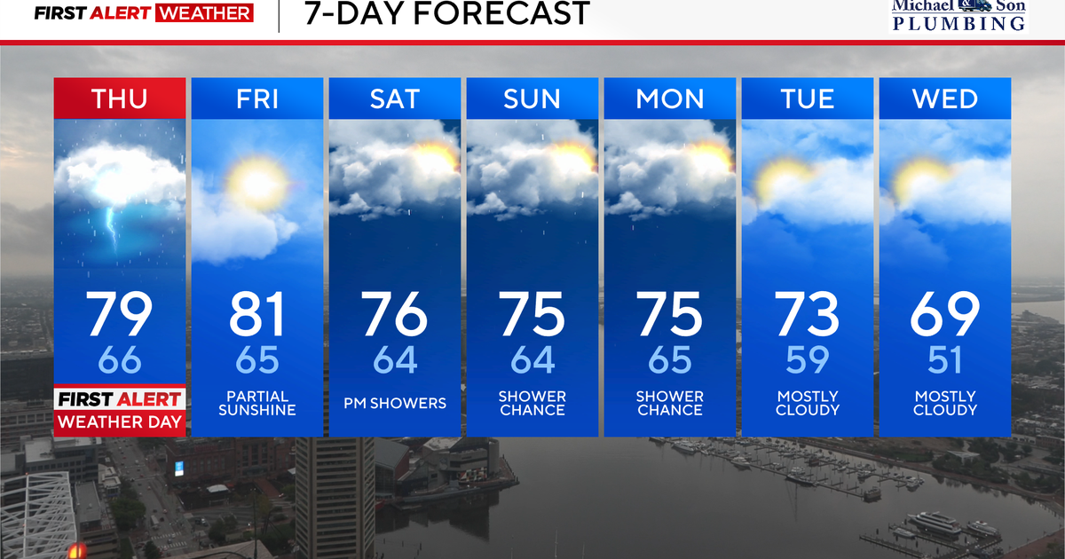
Alert Day Thursday for heavy showers and storms
Widespread showers and locally heavy thunderstorms are taking place on this Thursday morning. Expect a very slow morning commute as showers and storms continue to pivot into the area from the south and west. Heavy rainfall is likely with many of the showers and storms, so localized street and highway flooding is possible. Expect travel delays throughout the morning due to a few rounds of heavy showers and storms.
There is the threat for a few strong to severe storms this afternoon. The timeline for potential strong to severe storms would be from 4 p.m. until 8 p.m. The risk for severe storms is dependent on how much sunshine we receive during the midday and early afternoon hours. The less sun we receive, the greater the chance the storms won’t be severe. If we end up seeing more in the way of sunshine, then some of the storms could produce damaging winds, lightning, and an isolated tornado.
Stay with the WJZ First Alert Weather Team for updates throughout the day for any potential severe weather watches and/or warnings.
Any evening showers and storms should exit with skies staying partly to mostly cloudy overnight. Any areas that do see partial clearing could see some patchy dense fog form overnight tonight into Friday morning.
Drier Friday across Maryland before weekend showers develop
The front responsible for Thursday’s showers and storms will sink south of our area Thursday night into Friday. This will allow our weather to temporarily dry out.
Friday’s weather will be mainly dry with a partly to mostly cloudy sky. High temperatures will reach the lower 80s.
The stalled front to our south may slowly lift back north as waves of low pressure develop along it. This may bring back unsettled weather this weekend.
Right now Saturday appears to start dry, but will likely turn wet as a wave of low pressure moves by to our south. Showers appear likely Saturday into Sunday with high temperatures in the middle 70s.
Showery start to next week in Maryland, watching tropics
The showers may continue through Tuesday morning with the stalled frontal boundary south of us. Canadian high pressure should keep two tropical systems “Humberto” and what will likely become “Imelda” to our south. The strength of this area of Canadian high pressure and how these two storms interact with each other will be critical to the exact track of these storms.
Stay with the WJZ First Alert Weather Team as the exact path of what will be “Imelda” is still somewhat uncertain and may change. We will continue to bring you the latest with the projected strength and track of this storm as we head into the weekend and early next week.