COLUMBIA, S.C. (WCSC) – Every second counts in emergencies, and when first responders donŌĆÖt know basic information, like where to go, critical time is wasted.
That time becomes even more precious when kids are the ones who need help.
But a new tool will soon help law enforcement respond to crises at school.
As part of a larger effort to bolster school safety, the state is spending about $5 million, allocated in last yearŌĆÖs budget, to create digital maps of every public school in South Carolina to use in emergencies.
Their implementation was a major priority for State Superintendent of Education Ellen Weaver, backed by the governor and General Assembly.
ŌĆ£Every second matters in the event of a crisis to neutralize whatever the threat is on campus and to secure students and staff, and so if we can give law enforcement that one additional tool, this is one of the best uses of funds that we have in K-12 right now,ŌĆØ said Patrick Kelly with the Palmetto State Teachers Association.
Kelly knows that all too well.
The school where he teaches in Richland County was one of more than a dozen across South Carolina targeted with calls reporting a school shooter on campus on the same day about three years ago.
They all turned out to be fake, but the threat felt very real for the students and staff on campus, and the families worried about them.
ŌĆ£We need every law enforcement officer on that campus to have as much information about the campus as possible,ŌĆØ Kelly said.
By early next year, they should have a new way to get that invaluable information.
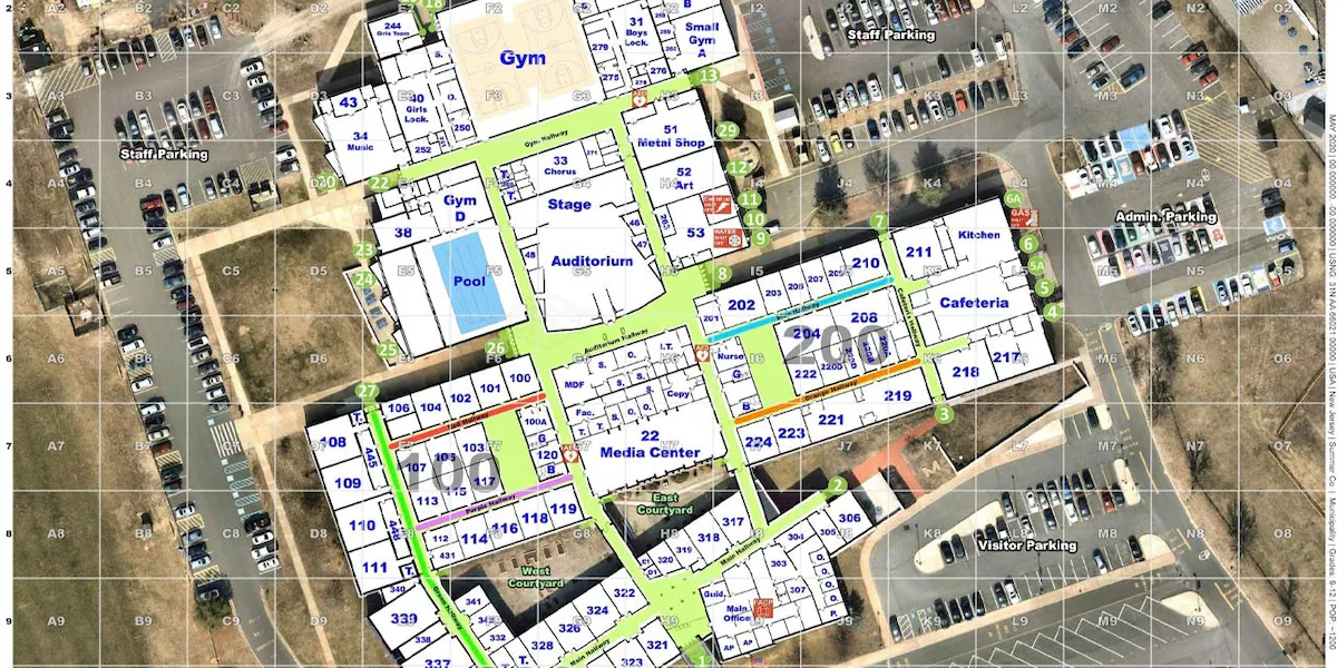
The South Carolina Department of Education has contracted with the company Critical Response Group to create digital maps for all 1,100-plus K-12 public schools in the state, which should be done by early next year.
CRG is in the process of visiting every one of those schools to build maps that will include floor plans and aerial views, according to CEO Mike Rodgers.
ŌĆ£We treat every school map as if our own children go to those schools, and ultimately, thatŌĆÖs where our company started. I started this company because my wifeŌĆÖs a schoolteacher, and I wanted to make sure her school was mapped to a very specific standard,ŌĆØ Rodgers said.
That information will only be available to first responders, who will be able to access it using technology they already have, Rodgers said.
ŌĆ£WeŌĆÖve got the highest levels of security to protect the data, and then we rely on the cyber posture of those individual police departments and 911 centers ŌĆö just like they protect all their other data, our maps live in the same environment, so the data is protected when itŌĆÖs in those systems,ŌĆØ he said.
In the wake of the hoax active shooter call at the University of South CarolinaŌĆÖs Columbia campus last month, law enforcement said these maps would be a major help on college campuses, too.
ŌĆ£So the responders sort of know where theyŌĆÖre going and have a better picture, especially if theyŌĆÖre not from the campus,ŌĆØ Capt. Brandon Landrum with the Protective Services/Emergency Management Unit of the South Carolina Law Enforcement Division told lawmakers during a recent hearing on school safety.
More and more states are implementing school maps, including in Georgia, where a law was enacted earlier this year to require the tool for every public school in the state.
After the state of South Carolina awarded CRG the contract to build maps for all its public schools, Rodgers said a number of private schools in the state have since reached out to them as well.
This is one of a handful of measures the state has taken in recent years to boost school safety.
South Carolina has also allocated money for every school in the state to hire a full-time school resource officer, awarded districts grants for safety upgrades, and created a state-of-the-art training center at a former school in Lexington County.