By Jacob Phillips
Copyright standard
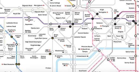
A map has revealed how central London has been turned into a virtual “train desert” on the final morning of the Tube strikes.
An interactive map on Transport for London’s (TfL) Go app shows just how few trains have been running through the city centre during five days of walkouts.
The usually colourful Tube map has been turned into a sea of grey, with only the Elizabeth line running through the West End.
Thameslink services are still open and able to whisk office workers into the City of London from the north and south of the capital.
Thousands of commuters have swapped rails for wheels as they try and get to work on buses and bikes.
Londoners have cycled to work in record numbers to beat the Tube strike – although some have been spotted riding through red lights.
An extraordinary two million trips are thought to have been made by ‘strikelysts’ on Monday, according to London cycling commissioner Will Norman.
Normally about 1.4m journeys are made by bike on weekdays.
Hundreds of cyclists have been spotted wheeling through Hyde Park Corner on strike days as key Tube lines such as the Victoria Line and Piccadilly Line remained down.
Research by the central London-based Centre for Economics and Business Research, carried out for The Standard, estimated the strikes will cause a direct £230m hit to the capital’s economy.
Further figures suggested footfall was down by up to a third in Canary Wharf, the city’s busy business district.
Data from Virgin Media O2 showed that footfall across central London at 1pm on Tuesday was down 16% compared with the same time a week earlier.
Footfall in Canary Wharf was down by 31%, London Bridge and the City down 21% and Westminster down 19%, according to the report.
Thursday is the last of five consecutive days of RMT walkouts in the union’s dispute with TfL over pay and working hours, which have crippled services and brought travel chaos to the capital.