By The Independent
Copyright independent
New tools aim to strengthen water security as climate risks mount in water-stressed African farming communities
NEWS ANALYSIS | RONALD MUSOKE | When the rains fail in southern Africa, the survival of crops often depends on how much water remains in the dams. For decades, that simple question has been surprisingly hard to answer, with field measurements often patchy, outdated, and prohibitively expensive.
Now, a coalition of research and policy organisations is attempting to change that. The Limpopo Watercourse Commission (LIMCOM), the International Water Management Institute (IWMI) and its partners, the CGIAR’s Accelerator for Digital Transformation, Digital Earth Africa, and the Digital Innovations for Water Secure Africa (DIWASA) project, have launched a system that uses satellite imagery and artificial intelligence to estimate water levels in reservoirs with near real-time accuracy.
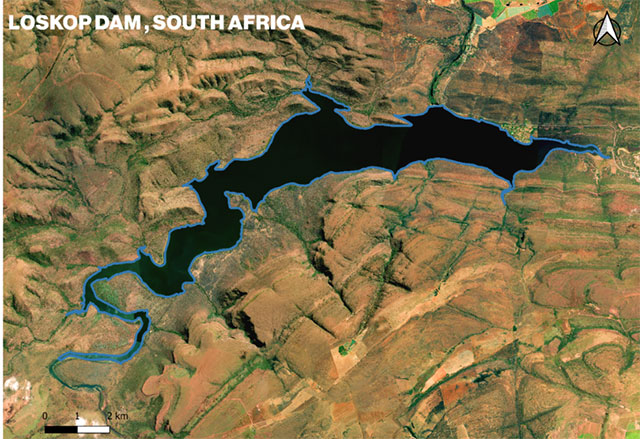
The project has begun with South Africa’s Limpopo River Basin, where the Loskop Dam supplies irrigation to more than 25,000 hectares of farmland. In a region of scarce and erratic rainfall, uncertainty over water availability has contributed to crop failures, tensions between users and recurring stress for farmers.
“The problem isn’t that we don’t have dams,” said Mariangel Garcia Andarcia, IWMI’s research group leader. “The problem is that we haven’t always had reliable information about how much water they hold. Without that knowledge, planning becomes guesswork.”
The new approach analyses visible changes in surface water captured by satellites and combines them with structural data about dams. Machine learning models then convert this information into storage estimates, switching between models depending on water levels to improve accuracy.
Unlike traditional monitoring methods, which rely on occasional manual readings, the system can deliver continuous insights without expensive equipment. Researchers say the shift could significantly improve planning for farmers, governments, and businesses that depend on water security. “This innovation shows how open access data can catalyse real-world impact,” Garcia Andarcia added.
Building a digital twin
The Limpopo River Basin, shared by South Africa, Botswana, Mozambique and Zimbabwe, has long struggled with uneven monitoring systems. The basin is also under growing pressure from agriculture, mining, and domestic demand, alongside climate-driven droughts and floods.
The new technology underpins the “Digital Twin” of the basin, a constantly updated virtual model that allows managers to visualise water use, assess risks and coordinate responses across borders. “For the first time, we can build a shared picture of what’s happening in the basin in close to real time,” an IWMI researcher said.
The platform relies on Landsat imagery processed by Digital Earth Africa, a Johannesburg-based non-profit that repackages more than 30 years of Earth observation records into user-friendly datasets.
To encourage wider adoption, IWMI and Digital Earth Africa have published their methodology openly. An interactive Jupyter Notebook on the Digital Earth Africa platform shows how governments, NGOs and researchers can replicate the water-level estimates for their own reservoirs.
With climate change projected to intensify rainfall extremes across Africa, reliable water monitoring is expected to become more critical.
“Now that we’re in the era of AI, we’re looking at how we can use AI to simplify complex science,” Garcia Andarcia said. “But equally important is training communities to understand what technology can do for them—so that we can be creative together in finding solutions.”
The initiative is already being discussed as a potential model for other regions, with possible applications ranging from flood forecasting to groundwater monitoring.
Leapfrogging infrastructure gaps
For much of Africa, where field-based monitoring networks are sparse, the ability to leapfrog directly to satellite- and AI-powered systems offers a rare chance to close long-standing information gaps.
“With platforms like Digital Earth Africa providing open access to satellite data, and organisations like IWMI bringing decades of expertise, we’re in a strong position to build a data-driven future for water management,” Garcia Andarcia said. For farmers in the Limpopo River Basin and beyond, that could mean one less uncertainty in a changing climate: knowing, with confidence, how much water remains when it is needed most.